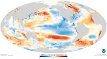
 Sea surface anomalies across the world in January 2011 during the 2010–2012 La Nina event. | |
| Meteorological history | |
|---|---|
| Formed | July 2010[nb 1] |
| Dissipated | April 2012 |
| Overall effects | |
| Damage | Significant |
| Areas affected | The Pacific Ocean and surrounding areas |
The 2010–2012 La Niña event was one of the strongest on record. It caused Australia to experience its wettest September on record in 2010, and its second-wettest year on record in 2010.[2] It also led to an unusual intensification of the Leeuwin Current,[3] the 2010 Pakistan floods, the 2010–2011 Queensland floods, and the 2011 East Africa drought. It also helped keep the average global temperature below recent trends, leading to 2011 tying with 1997 for the 14th-warmest year on record. This La Niña event also led to above-average tropical cyclone activity in the North Atlantic Ocean during the 2010, 2011, and 2012 hurricane seasons, while the Eastern and Western Pacific experienced record low activity in 2010 and below average activity in 2011.
Meteorological progression
The 2009–2010 El Niño event started in the Pacific Ocean during May 2009, before it reached it peaked during December and broke down during the first quarter of 2010.[4][5] The climate of the Pacific Ocean subsequently returned to neutral conditions by the end of April, while climate models used and developed by various meteorological agencies, subsequently started to show signs that a La Niña event would develop later in 2010.[6] Over the next month the Pacific Ocean started to show various signals that indicated a La Niña event was developing and as a result, a La Niña watch was issued by the United States Climate Prediction Center during their June 2010 ENSO diagnostic discussion.[4][7] As the ocean's surface temperature cooling progressed, more colder anomalies appeared at the International Date Line rather than over eastern Pacific, what allowed calling this event as a Modoki one.[8]
Impacts
Australia experienced its second- and third-wettest years, since a record of the rainfall started to kept during 1900.[4] Winter saw above average snowfall in much of the Western United States as well as the Midwest. With the exception of the Southern Rockies, Western Mountains saw snowpack totals above 180% of normal.[9] Meanwhile, the 2011 Groundhog Day blizzard caused record snowfall in Chicago and forced the city to shutdown. Because this was a La Niña, it brought California the wettest December on record and the summer of 2011 was California's wettest. The Pacific Northwest saw 2011 being one of the coolest, wettest years on record, with temperatures still in the 50s and rain/snow mix even in May. The Midwest and Northeastern United States also experienced an extremely wet 2011, leading to flooding across the Mississippi River, Missouri River, and the Ohio River. The La Nina is also blamed for the record tornado activity across the Southern U.S during Spring 2011, especially the Super Outbreak, which is the largest and costliest tornado outbreak in recorded history, as well as being one of the most violent and one of the deadliest. [9] The 2010–2013 Southern United States and Mexico drought caused low streamflow, agricultural distress, and wildfires throughout the Southern Plains and Georgia. The worst effects were felt in Texas, where 2011 was the driest calendar year on record as well as the third warmest.[10]
Notes
- ↑ Each meteorological agency that monitors the state of the El Niño–Southern Oscillation, has a different definition of what constitutes an El Niño event tailored to their needs.[1]
References
- ↑ Becker, Emily (4 December 2014). "December's ENSO Update: Close, but no cigar". ENSO Blog. Archived from the original on 22 March 2016.
- ↑ "The 2010–11 La Niña: Australia soaked by one of the strongest events on record". Bureau of Meteorology. Retrieved July 22, 2015.
- ↑ "La Niña forces unprecedented Leeuwin Current warming in 2011 : Scientific Reports : Nature Publishing Group". Nature.com. Retrieved July 22, 2015.
- 1 2 3 Record-breaking La Niña events (PDF) (Report). Australian Bureau of Meteorology. July 2012. Archived (PDF) from the original on March 4, 2016. Retrieved March 20, 2016.
- ↑ "Historical El Niño/La Niña episodes (1950–present)". United States Climate Prediction Center. 4 November 2015. Retrieved 10 January 2015.
- ↑ "ENSO Wrap-Up: Neutral conditions returning to the Pacific" (PDF). Australian Government. Bureau of Meteorology. 28 April 2010. Retrieved 2022-03-19.
- ↑ El Niño/Southern Oscillation (ENSO) diagnostic discussion: June 2010 (PDF) (Report). United States Climate Prediction Center. June 3, 2010. Archived (PDF) from the original on 6 August 2016.
- ↑ V. Platonov; E. Semenov; E. Sokolikhina (2014-02-13). "Extreme La-Nina 2010/11 and the vigorous flood at the north-east of Australia" (PDF). EGU General Assembly/Geophysical Research. Retrieved 2014-10-15.
- 1 2 "National Climate Report - Annual 2011. State of the Climate". National Centers for Environmental Information (NCEI). Retrieved 2021-03-06.
- ↑ "National Climate Report - Annual 2011. State of the Climate". National Centers for Environmental Information (NCEI). Retrieved 2021-05-06.