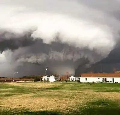
 The tornado near peak intensity near Deer Creek. | |
| Meteorological history | |
|---|---|
| Duration | 41 minutes |
| Formed | April 9, 2015, 6:39 p.m. CDT |
| Dissipated | April 9, 2015, 7:20 p.m. CDT |
| EF4 tornado | |
| on the Enhanced Fujita scale | |
| Overall effects | |
| Fatalities | 2 |
| Injuries | 22 |
| Damage | $19 million (2015 USD) $23.5 million (2024 USD)[1] |
| Areas affected | Lee, Ogle, DeKalb, Boone Counties, Illinois |
Part of the tornado outbreak of April 8–9, 2015 | |
Throughout the evening hours of April 9, 2015, an extremely violent and long-lived multiple-vortex tornado tore through the communities near Rochelle and in Fairdale, Illinois. Part of a larger severe weather event that impacted the Central United States, the tornado first touched down in Lee County at 6:39 p.m. CDT (22:39 UTC). It progressed through the counties of Ogle, DeKalb, and Boone before finally dissipating at 7:20 p.m. CDT. Along the tornado's 30.14-mile (48.51 km) path, numerous structures were heavily damaged or destroyed, especially in the small town of Fairdale where two fatalities and eleven injuries were recorded. A few well-constructed homes were swept completely away, indicative of peak winds near 200 mph (320 km/h), the upper bounds of an EF4 tornado. In the aftermath of the event, hundreds of citizens assisted in cleanup and recovery efforts. Economic losses from the tornado reached $19 million (equivalent to $23,000,000 in 2022).
Meteorological synopsis
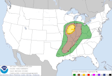
On April 4, 2015, the Storm Prediction Center (SPC) issued their Day 6 severe weather outlook, highlighting a substantial and widespread risk for severe weather from southeastern Oklahoma to northeastern Illinois valid for April 9.[2] This threat area was maintained in the Day 5 outlook and narrowed to a corridor from southern Missouri into northern Illinois in the Day 4 outlook.[3][4] On April 7, a Day 3 Enhanced risk was issued across most of Illinois, eastern Missouri, and small portions of adjacent states. No further changes to the threat level were made, although the Enhanced risk was significantly expanded late on April 8 to include portions of the southern Great Lakes, lower Ohio Valley, Ozark Plateau, and Arklatex region.[5] Around midday on April 9, the SPC issued a 10% hatched tornado threat area across much of northern Illinois and small portions of nearby states, signifying the potential for several tornadoes, of which one or two had the potential to be strong (EF2 or stronger on the Enhanced Fujita scale).[6]

The catalyst for the severe weather outbreak came as a positively-tilted shortwave trough progressed across the central High Plains into the Great Plains and eventually through the western Great Lakes region. A weaker disturbance pushed from the Ozarks into the Northeastern United States, acting to strengthen southwesterly winds aloft across the risk area. At the surface, a weak area of low pressure initially centered over northeastern Kansas early on April 9 progressed steadily northeast while intensifying, reaching the trisection of Iowa, Wisconsin, and Illinois by late that evening. A cold front stemming from the low progressed eastward across the Mid-South, whereas an arching warm front slowly pushed northward across eastern Iowa and northern Illinois. Modest surface heating ahead of the cold front allowed mid-level Convective Available Potential Energy (CAPE) values to reach 1,000–1,500 J/kg, and a mass of rich moisture transported northward from the Gulf of Mexico pushed dewpoints into the lower 60s °F across the Enhanced risk area.[7] Winds at 850 mb (4,781 ft) strengthened at or above 45 mph (72 km/h) below winds of 70 mph (110 km/h) at 700 m (2,300 ft), creating a favorable setup for sustained supercells. Although the overall directional component of low-level winds was expected to be less than ideal as a whole, a small area of southeasterly surface winds developed near the surface low in northern Illinois.[6]
At 1:50 p.m. CDT (18:50 UTC), the SPC issued a tornado watch for northern and central Illinois, far northwestern Indiana, far southern Wisconsin, and portions of Lake Michigan. A 60% chance of two or more tornadoes was assessed across the watch box, with a 40% chance of at least one strong tornado.[8] Isolated shower activity began forming across the region just prior to the issuance of watch,[9] eventually growing into a line of strong to severe thunderstorms, including supercells.[10] One such high-precipitation supercell was first severe warned at 6:11 p.m. CDT (23:11 UTC); the National Weather Service office in Chicago, Illinois warned of winds up to 70 mph (110 km/h) and quarter- to golf ball-sized hail.[11] The weather forecast office upgraded the severe thunderstorm warning to a tornado warning at 6:35 p.m. CDT (23:35 UTC), and four minutes later, trained storm spotters reported a damaging tornado north of Ashton.[12] This was one of several tornadoes observed across the Central United States on April 8 and April 9.[13]
Impact

The tornado first began at 6:39 p.m. CDT (23:39 UTC) on April 9, just northeast of Franklin Grove, Illinois. It touched down over a field, producing swirls in crops, before moving northeast and causing EF1 damage to the Crest Foods plant. The tornado soon exited Lee County and entered Ogle County, inflicting EF1 damage to two farm outbuildings that were completely destroyed and EF0 damage to a similar structure that had a portion of its roof uplifted. Intensifying to EF3 strength, much more severe damage was noted along South Skare Court as the tornado entered an area of semi-rural subdivisions to the northwest of Rochelle. A few homes in this area were destroyed at EF3 intensity, with other homes nearby sustaining EF2 damage. One large house had a room ripped off on its second floor, while a split-level home was almost completely leveled.[14]
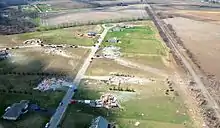
As the tornado crossed South Richard Road, it intensified to very high-end EF4 strength and inflicted catastrophic damage to several large homes as it impacted the Deer Creek subdivision. Well-built homes along South Richard Road and East Kuehl Court were leveled and swept from their foundations with debris strewn downwind. Several vehicles parked at these residences were moved some distance or tossed, and wind rowing of debris occurred. One house had its concrete walkway pulled a few inches from its original location, and notable scouring of lawn grass was observed in the subdivision. These structures were estimated to have been impacted by winds near 200 mph (320 km/h), the upper bound of an EF4 tornado. Continuing northeast, the tornado temporarily weakened, producing EF2 to EF3 damage as it destroyed a few large barns or outbuildings, ripped the roof off two brick residences, and collapsed most walls of another house, but once again gained strength as it approached and crossed IL 64. A large restaurant and a residence had their exterior walls collapsed in this area.[14]

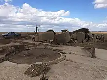
Very high-end EF4 damage was again observed near the intersection of IL 64 and IL 251, where a row of five homes was completely leveled, two of which were swept away. Anchor bolts were again present at these residences, though the foundations were of cinder-block construction. Intense ground scouring was evident nearby, a car was thrown a full mile, and debris was wind-rowed long distances through fields in this area. Winds were again estimated at 200 mph (320 km/h), with the damage at this location again being near-EF5 in intensity. Further to the northeast, the tornado inflicted high-end EF4 damage as a large farmstead was completely destroyed. A well-constructed barn was obliterated, and a 40 ft (12 m) reinforced concrete silo was reduced to a pile of rubble. A large farmhouse on the property was completely swept away, and nearby trees were severely stripped and debarked. The tornado weakened as it crossed North Moore Road, where a warehouse building had a collapse of its non-bearing exterior walls. One small barn or outbuilding had a collapse of exterior walls while another had a few metal roof panels ripped off. After crossing Interstate 39, it caused moderate roof damage to a large residence and tossed and rolled a heavy barn. The tornado continued to produce generally EF1 damage to trees and outbuildings before exiting Ogle County, and it was briefly accompanied by an EF0 satellite tornado that damaged crops to its southeast.[14]
After entering DeKalb County, the large tornado directly impacted the small community of Fairdale. Approximately 71 homes sustained some degree of damage, including 13 that were destroyed. Several houses on the northwest side of town sustained damage consistent with an upper-end EF3 tornado, with all walls collapsed. A few houses that were nailed to the foundation—not bolted—were swept clean. Neighbors Geraldine Schultz and Jacklyn Klosa were both killed in their homes, and an additional 11 people were injured throughout the town, including Geraldine's husband, Clarence.[15] Continuing northeast across Wheeler Road, one residence had a large portion of its roof ripped off, a second residence had its exterior walls collapsed, and a two-story 80-year-old well-constructed barn was destroyed. A large garage was destroyed and had its debris deposited well downstream, and significant denuding and debarking of trees was evident. Near the intersection of Irene Road and McNeal Road, a well-built seven-year-old house lost its second story and many exterior walls. A two-story well-built barn with cinder block attachment was totally destroyed, and a nearby two-story rebar-reinforced cinder block silo was ripped apart. Large farm equipment was tossed 0.25–0.5 mi (0.40–0.80 km), and convergent scouring of road pavement was noted in this area. After passing over rural terrain, the tornado finally dissipated at 7:20 p.m. CDT (00:20 UTC) over Cherry Valley Road, ending its 30.14 mi (48.51 km) and 41-minute path of destruction.[14]
Clem Schultz video
The disaster was captured on phone camera by Clarence "Clem" Schultz (85), who recorded the tornado from his home. Mr. Schultz survived with a compressed broken vertebra, but his wife, Geraldine "Geri" Schultz (67), and their neighbor, Jacklyn Klosa (69), were killed. The Schultzes' dog, Missy, and Clem's phone with the footage were found unharmed after the disaster. The footage which captured the tornado's approach and destruction of several houses (including the homes of Klosa and the Schultzes) was recovered and was released online and in news broadcasts as a cautionary example.[16][17]
Aftermath
In the immediate wake of the tornado, The Salvation Army and American Red Cross set up temporary shelters for residents in Fairdale.[18] The Rochelle Community Hospital was shifted into "disaster mode" to quickly handle the large number of casualties.[19] Equipment and resources from over a dozen nearby fire departments aided in sifting through the remains of dozens of houses.[20] More than 675 volunteers, coordinated by the Virginia faith-based nonprofit organization Operation Blessing, and countless residents from surrounding areas assisted in cleanup efforts.[21] AmeriCorps coordinated their own operations beginning on April 12.[22] Switchyard Bar and Grill in Rochelle hosted a donation drive to provide victims with new household items.[23] Ogle County Sheriff Brian VanVickle and DeKalb County Sheriff Roger Scott set up a lost-and-found for residents to retrieve missing items.[24] Workers from "Bees Designs" created and sold shirts in Rochelle, with all proceeds donated to help tornado victims.[25] A check from near Rochelle was discovered approximately 80 mi (130 km) northeast in Racine, Wisconsin, a common occurrence with violent tornadoes.[26] Widespread severe weather across northern Illinois prompted the cancellation of more than 850 flights at Chicago O'Hare International Airport.[27] Governor Bruce Rauner declared DeKalb and Ogle counties as state disaster areas, freeing up a wide variety of resources for response efforts. Both the governor and Illinois U.S. Senator Mark Kirk toured the area.[28] Total economic losses from the tornado reached $19 million (equivalent to $23,000,000 in 2022[1]).[29][30][31][32]
See also
References
- 1 2 1634–1699: McCusker, J. J. (1997). How Much Is That in Real Money? A Historical Price Index for Use as a Deflator of Money Values in the Economy of the United States: Addenda et Corrigenda (PDF). American Antiquarian Society. 1700–1799: McCusker, J. J. (1992). How Much Is That in Real Money? A Historical Price Index for Use as a Deflator of Money Values in the Economy of the United States (PDF). American Antiquarian Society. 1800–present: Federal Reserve Bank of Minneapolis. "Consumer Price Index (estimate) 1800–". Retrieved May 28, 2023.
- ↑ Steve Goss (April 4, 2015). "Day 4-8 Severe Weather Outlook Issued on Apr 4, 2015". Storm Prediction Center. Retrieved January 29, 2017.
- ↑ Steve Goss (April 5, 2015). "Day 4-8 Severe Weather Outlook Issued on Apr 5, 2015". Storm Prediction Center. Retrieved January 29, 2017.
- ↑ Steve Goss (April 6, 2015). "Day 4-8 Severe Weather Outlook Issued on Apr 6, 2015". Storm Prediction Center. Retrieved January 29, 2017.
- ↑ Brynn Kerr (April 8, 2015). "Apr 8, 2015 1730 UTC Day 2 Convective Outlook". Storm Prediction Center. Retrieved January 29, 2017.
- 1 2 Stephen Corfidi; Jeremy Grams; Matt Mosier (April 9, 2015). "Apr 9, 2015 1630 UTC Day 1 Convective Outlook". Storm Prediction Center. Retrieved January 29, 2017.
- ↑ Chris Broyles; Joey Picca (April 9, 2015). "Apr 9, 2015 1200 UTC Day 1 Convective Outlook". Storm Prediction Center. Retrieved January 30, 2017.
- ↑ Jeremy Grams; Stephen Corfidi (April 9, 2015). "Tornado Watch 41". Storm Prediction Center. Retrieved January 30, 2017.
- ↑ Mark Darrow; Jeremy Grams (April 9, 2015). "Mesoscale Discussion 246". Storm Prediction Center. Retrieved January 30, 2017.
- ↑ Matt Mosier (April 9, 2015). "Mesoscale Discussion 251". Storm Prediction Center. Retrieved January 30, 2017.
- ↑ "Severe Weather Statement: Severe Thunderstorm Warning". Iowa Environmental Mesonet. April 9, 2015. Retrieved January 30, 2017.
- ↑ "Severe Weather Statement: Tornado Warning". Iowa Environmental Mesonet. April 9, 2015. Retrieved January 30, 2017.
- ↑ April 9, 2015 Tornado Event, Including Rochelle/Fairdale EF-4 Tornado (Report). National Weather Service. National Weather Service Weather Forecast Office in Chicago, Illinois. April 10, 2015. Retrieved April 28, 2017.
- 1 2 3 4 "NWS Damage Assessment Toolkit". National Weather Service. Retrieved January 29, 2017.
- ↑ "Death toll reaches 2 in Fairdale tornado". Shaw Local. 2015-04-10. Retrieved 2023-05-18.
- ↑ Angela Fritz (April 6, 2016). "A huge tornado killed his wife and destroyed their home. He filmed the whole thing". The Washington Post. Retrieved January 31, 2017.
- ↑ Elizabeth Armstrong Moore (April 6, 2017). "Elderly Man Films Tornado That Kills His Wife, Neighbor". Newser. Retrieved October 22, 2021.
- ↑ Bruce Wright (April 10, 2015). "Illinois Tornado 2015: Fairdale, Rochelle Survivors React To Storm That Killed 1, Injured At Least 7". International Business Times. Retrieved January 31, 2017.
- ↑ Catherine E. Shoichet; et al. (April 9, 2015). "Severe weather: Tornadoes hit Iowa, Illinois, Ohio". Cable News Network. Fox 5 News. Retrieved January 31, 2017.
- ↑ Mike Danahey (April 11, 2015). "Elgin area firefighters part of tornado relief and rescue efforts". Elgin Courier-News. Retrieved January 31, 2017.
- ↑ Scott C. Morgan (April 11, 2015). "Volunteers flock to Rochelle to help with tornado cleanup". Daily Herald. Retrieved January 31, 2017.
- ↑ "Volunteer Information for Fairdale and Rochelle". WIFR-TV. April 12, 2015. Retrieved January 31, 2017.
- ↑ Erik Runge (April 11, 2015). "Volunteers needed again Sunday in tornado-stricken Rochelle". WGN-TV. Retrieved January 31, 2017.
- ↑ Tony Briscoe (April 23, 2015). "Sheriff whose home was razed by tornado gets grandfather's baseball glove back". Chicago Tribune. Retrieved January 31, 2017.
- ↑ Phillip Reed (April 16, 2015). "Despite Last Thursday's Tornado, Rochelle Residents Remain 'Hub Strong'". MyStateLine. Retrieved January 31, 2017.
- ↑ Jon Erdman (April 14, 2015). "Rochelle, Fairdale Tornado Debris Found Up to 80 Miles Away". Retrieved January 31, 2017.
- ↑ "Tornado rocks Illinois, kills one, traps 11 in restaurant storm cellar". Oregon Live. Associated Press. April 9, 2015. Retrieved January 31, 2017.
- ↑ Juan Perez Jr.; et al. (April 10, 2015). "Illinois tornado that killed 2, destroyed town packed EF4 punch". Chicago Tribune. Retrieved January 31, 2017.
- ↑ Illinois Event Report: EF1 Tornado (Report). National Centers for Environmental Information. National Weather Service Weather Forecast Office in Chicago, Illinois. 2015. Retrieved January 31, 2017.
- ↑ Illinois Event Report: EF4 Tornado (Report). National Centers for Environmental Information. National Weather Service Weather Forecast Office in Chicago, Illinois. 2015. Retrieved January 31, 2017.
- ↑ Illinois Event Report: EF3 Tornado (Report). National Centers for Environmental Information. National Weather Service Weather Forecast Office in Chicago, Illinois. 2015. Retrieved January 31, 2017.
- ↑ "Illinois Event Report: EF0 Tornado". National Centers for Environmental Information. National Weather Service. Retrieved 2 August 2022.
External links
- NWS Chicago's Event Report for the April 9, 2015 tornado outbreak
- Video of a close encounter with the Rochelle tornado
- Man films the tornado as it hits his house