 | |
|---|---|
 | |
| Route information | |
| Part of | |
| Length | 52.3 km (32.5 mi) |
| Major junctions | |
| North end | A40 |
| South end | Lyon |
| Location | |
| Country | France |
| Highway system | |
| |
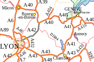
The A42 autoroute is a short motorway in France. Being completed in 1987, the road connects the city of Lyon to its junction with the A40 roughly 50 km north-east of Lyon.
Characteristics
History
- 1983: Section between Neyron and Chazey (30 km) opened
- 1988: Section between Chazey and Pont-d'Ain (19.5 km) opened
Junctions
| Exit/Junction | Destination |
| Lyon-Avenue Jean Mermoz Autoroute commences in Lyon City Centre | |
| (Lyon: porte de Croix-Barret) Towns served Lyon Centre, Périphérique ( | |
| (Villeurbanne Croix-Luizet-St Jean) Towns served: Villeurbanne Croix-Luizet, St Jean | |
| (Vauix-en-Velin) Towns served: Vauix-en-Velin | |
| Exchange A42-N346 Junction with | |
| Exchange A42-A46 Junction with | |
| (Parc de Miribel-Jonage) Towns served: Neyron and Miribel | |
| (Beynost) Towns served: Beynost | |
| Exchange A42-A432 Junction with the | |
| (Balan-Dagneux) Towns served: Montluel and Balan | |
| (Pérouges) Towns served: Pérouges, Meximieux and Saint-Jean-de-Niost | |
| (Ambérieu) Towns served: Ambérieu-en-Bugey | |
| (Pont-d'Ain) Towns served: Pont-d'Ain | |
| Exchange A42-A40 Junction with | |
External links
Template:Attached KML/A42 autoroute
KML is from Wikidata
- A42 autoroute in Saratlas
| Metropolitan France |
|  |
|---|---|---|
| Overseas France | ||
| Planned routes |
| |
| Old or decommissioned routes | ||
This article is issued from Wikipedia. The text is licensed under Creative Commons - Attribution - Sharealike. Additional terms may apply for the media files.