 | |
|---|---|
 | |
| Route information | |
| Part of | |
| Length | 70.4 km (43.7 mi) |
| Existed | 1992–present |
| Major junctions | |
| West end | Romans-sur-Isère |
| East end | Grenoble |
| Location | |
| Country | France |
| Highway system | |
| |
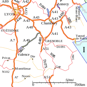
The A49 autoroute is a motorway in France. The road provides a connection between Romans (Valence) with Grenoble.
History
The first section was opened in 1991 between the junction with the A48 towards Voreppe and the junction at Tullins (N°11). Its extension to Romans-sur-Isère was opened in 1992.
Junctions
| Exit/Junction | Destination |
| Exchange A48-A49 Junction with | |
| (Tullins) Towns served: Tullins | |
| (Vinay) Towns served: Vinay | |
| (Saint-Marcelin) Towns served: Saint-Marcelin | |
| (Saint-Nazaire-en-Royans) Towns served: Saint-Nazaire-en-Royans | |
| (Novel-de-Isere) Towns served: Romans-sur-Isere | |
| (Bourg-de-Péage) Towns served: Romans-sur-Isere, Bourg-de-Péage | |
| The A49 becomes the | |
| (Les Soubres) | |
| (Valance TGV) | |
| (St-Marcel-lès-Valence) | |
| (Le Plovier) | |
| Exchange N532-N7 Road joins the | |
References
External links
Template:Attached KML/A49 autoroute
KML is from Wikidata
- A49 autoroute in Saratlas
| Metropolitan France |
|  |
|---|---|---|
| Overseas France | ||
| Planned routes |
| |
| Old or decommissioned routes | ||
This article is issued from Wikipedia. The text is licensed under Creative Commons - Attribution - Sharealike. Additional terms may apply for the media files.