New Valley Governorate | |
|---|---|
 | |
 Flag  | |
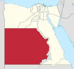
 New Valley Governorate on the map of Egypt | |
| Coordinates: 24°32′44″N 27°10′24″E / 24.54556°N 27.17333°E | |
| Country | |
| Seat | Kharga (capital) |
| Government | |
| • Governor | Mohammed Salman Mousa Al-Zamlout[1] |
| Area | |
| • Total | 440,098 km2 (169,923 sq mi) |
| Population (January 2023)[2] | |
| • Total | 265,003 |
| • Density | 0.60/km2 (1.6/sq mi) |
| Time zone | UTC+2 (EET) |
| ISO 3166 code | EG-WAD |
| HDI (2021) | 0.738[3] high · 10th |
| Website | www |

New Valley Governorate or El Wadi El Gedid Governorate (Arabic: محافظة الوادي الجديد [moˈħɑfzet elˈwæːdi lɡɪˈdiːd], Muḥāfaẓah al Wādī al Jadīd) is one of the governorates of Egypt. It is in the southwestern part of the country, in the south of Egypt Western Desert (part of the Sahara Desert), between the Nile, northern Sudan, and southeastern Libya.
Consisting of roughly half of Egypt's area, this spacious governorate is the country's largest and most sparsely populated, and one of the biggest subnational divisions on the African continent, as well as the world. At 440,098 square kilometers in area, New Valley Governorate is just slightly larger than the country of Iraq. The capital is at the Kharga Oasis. New Valley Governate is named after the New Valley Project, which aims to irrigate parts of the Western Desert.
Municipal divisions
The governorate is divided into municipal divisions with a total estimated population as of January 2023 of 265,003. In the case of New Valley governorate, there is one kism with urban and rural parts, and four marakiz.[2]
| Anglicized name | Native name | Arabic transliteration | Population (January 2023 Est.) | Type |
|---|---|---|---|---|
| Kharga | قسم الواحات الخارجة | Al-Wāḥāt al-Khārijah | 104,683 | Kism (urban and rural parts) |
| Balat | مركز بلاط | Balāṭ | 13,025 | Markaz |
| Dakhla | مركز الداخلة | Al-Dākhlah | 95,019 | Markaz |
| Farafra | مركز الفرافرة | Al-Farāfirah | 37,509 | Markaz |
| Baris | مركز باريس | Bārīs | 14,767 | Markaz |
In an effort to decentralize the administration of Kharga, it was divided into four sections effective 19 June, 2018.[4]
Population
According to population estimates, in 2015 the majority of residents in the governorate lived in rural areas, with an urbanization rate of only 48.0%. Out of an estimated 225,416 people residing in the governorate, 117,180 people lived in rural areas and only 108,236 lived in urban areas.[5][6]
According to population estimates, in 2018 the population was 245,000, with an urbanization rate of 46.7%.[7]
Cities, towns, oases
New Valley has a number of cities, towns and oases. As of 2018, Kharga Oasis, and Dakhla Oasis were the two places in New Valley with a population of over 15,000. Farafra Oasis and Baris Oasis are also in New Valley.[8]
| Anglicized name | Native name | Arabic transliteration | Nov. 1996 Census | Nov. 2006 Census | Population (July 2017 Est.) |
|---|---|---|---|---|---|
| Kharga Oasis | الخارجة | Al-Khārijah | 49,446 | 60,584 | 72,558 |
| Dakhla | الداخلة | Mūṭ (Ad-Dākhlah) | 16,252 | 20,439 | 23,415 |
Industrial zones
According to the Egyptian Governing Authority for Investment and Free Zones (GAFI), in affiliation with the Ministry of Investment (MOI), the following industrial zones are located in this governorate:[9]
- Al Kharga
- Heavy industrial zone - El Dakhla
- Heavy industrial zone - Wadi Waer West
New Valley also contains some farming areas created by the New Valley project, like Sharq El Owainat.

History
- 2011 Egyptian revolution
Violent clashes were reported in the New Valley Governorate on February 8–9, 2011 as part of the 2011 Egyptian revolution. Protesters set fire to police stations and the National Democratic Party building. Multiple deaths were reported in addition to hundreds of injuries amid claims that the police opened fire on protesters in Kharga Oasis with live ammunition.[10][11]
Industry
- Farming of dates
- Tourism and safaris
- Agricultural activities (around oases)
See also
References
- ↑ "رسمياً.. المحافظون الجدد ونوابهم يؤدون اليمين الدستورية أمام الرئيس". Almasry Alyoum (in Arabic). 30 August 2018. Archived from the original on 31 August 2018. Retrieved 31 August 2018.
- 1 2 "ﻋـــﺩﺩ ﺍﻟﺳﻛــﺎﻥ ﺍﻟﺗﻘﺩﻳﺭﻯ ﻟﻸﻗﺳــﺎﻡ" (PDF). www.capmas.gov.eg (in Arabic). Retrieved 3 April 2023.
- ↑ "Sub-national HDI - Subnational HDI - Table - Global Data Lab". globaldatalab.org. Retrieved 20 February 2023.
- ↑ "Divide the city of Kharja into 4 districts and appoint its chiefs". El Watane News (in Arabic). 19 June 2018. Archived from the original on 25 November 2018. Retrieved 24 November 2018.
- ↑ "Population Estimates By Sex & Governorate 1/1/2015" (PDF). CAPMAS. Archived (PDF) from the original on 19 October 2015. Retrieved 23 October 2016.
- ↑ "Population Estimates By Sex & Governorate 1/1/2015" (PDF). CAPMAS. Archived (PDF) from the original on 19 October 2015. Retrieved 17 October 2016.
- ↑ "Egypt in Figures 2018". Archived from the original on 2 November 2018.
- ↑ "Cities". CityPopulation.de. Archived from the original on 5 October 2018. Retrieved 24 November 2018.
- ↑ "Industrial Zones of Governorate". Ministry of Investment Egypt. Archived from the original on 23 November 2018. Retrieved 23 November 2018.
- ↑ "Live blog Feb 9 - Egypt protests | al Jazeera Blogs". Archived from the original on 23 July 2011. Retrieved 9 February 2011.
- ↑ Fahim, Kareem; Kirkpatrick, David D. (9 February 2011). "Labor Actions in Egypt Boost Protests". The New York Times. ISSN 0362-4331. Retrieved 12 May 2023.