Alabama Avenue | |||||||||||||||||||||||||||||||||||||||||||||||||||||||||||||||||||||||||||
|---|---|---|---|---|---|---|---|---|---|---|---|---|---|---|---|---|---|---|---|---|---|---|---|---|---|---|---|---|---|---|---|---|---|---|---|---|---|---|---|---|---|---|---|---|---|---|---|---|---|---|---|---|---|---|---|---|---|---|---|---|---|---|---|---|---|---|---|---|---|---|---|---|---|---|---|
 Looking west from the platform | |||||||||||||||||||||||||||||||||||||||||||||||||||||||||||||||||||||||||||
| Station statistics | |||||||||||||||||||||||||||||||||||||||||||||||||||||||||||||||||||||||||||
| Address | Alabama Avenue & Fulton Street Brooklyn, NY 11207 | ||||||||||||||||||||||||||||||||||||||||||||||||||||||||||||||||||||||||||
| Borough | Brooklyn | ||||||||||||||||||||||||||||||||||||||||||||||||||||||||||||||||||||||||||
| Locale | East New York, Cypress Hills | ||||||||||||||||||||||||||||||||||||||||||||||||||||||||||||||||||||||||||
| Coordinates | 40°40′37″N 73°54′00″W / 40.67683°N 73.900008°W | ||||||||||||||||||||||||||||||||||||||||||||||||||||||||||||||||||||||||||
| Division | B (BMT)[1] | ||||||||||||||||||||||||||||||||||||||||||||||||||||||||||||||||||||||||||
| Line | BMT Jamaica Line | ||||||||||||||||||||||||||||||||||||||||||||||||||||||||||||||||||||||||||
| Services | J Z | ||||||||||||||||||||||||||||||||||||||||||||||||||||||||||||||||||||||||||
| Transit | |||||||||||||||||||||||||||||||||||||||||||||||||||||||||||||||||||||||||||
| Structure | Elevated | ||||||||||||||||||||||||||||||||||||||||||||||||||||||||||||||||||||||||||
| Platforms | 1 island platform | ||||||||||||||||||||||||||||||||||||||||||||||||||||||||||||||||||||||||||
| Tracks | 2 | ||||||||||||||||||||||||||||||||||||||||||||||||||||||||||||||||||||||||||
| Other information | |||||||||||||||||||||||||||||||||||||||||||||||||||||||||||||||||||||||||||
| Opened | September 5, 1885[2] | ||||||||||||||||||||||||||||||||||||||||||||||||||||||||||||||||||||||||||
| Opposite- direction transfer | Yes | ||||||||||||||||||||||||||||||||||||||||||||||||||||||||||||||||||||||||||
| Traffic | |||||||||||||||||||||||||||||||||||||||||||||||||||||||||||||||||||||||||||
| 2022 | 365,853[3] | ||||||||||||||||||||||||||||||||||||||||||||||||||||||||||||||||||||||||||
| Rank | 402 out of 423[3] | ||||||||||||||||||||||||||||||||||||||||||||||||||||||||||||||||||||||||||
| |||||||||||||||||||||||||||||||||||||||||||||||||||||||||||||||||||||||||||
| |||||||||||||||||||||||||||||||||||||||||||||||||||||||||||||||||||||||||||
| |||||||||||||||||||||||||||||||||||||||||||||||||||||||||||||||||||||||||||
| |||||||||||||||||||||||||||||||||||||||||||||||||||||||||||||||||||||||||||
| |||||||||||||||||||||||||||||||||||||||||||||||||||||||||||||||||||||||||||
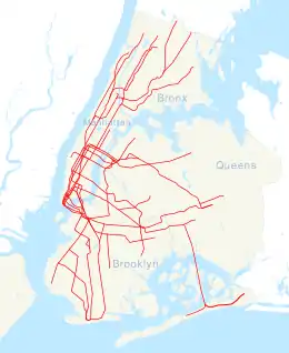
The Alabama Avenue station is an elevated station on the BMT Jamaica Line of the New York City Subway. Located at the intersection of Alabama Avenue and Fulton Street in East New York, Brooklyn,[4] it is served by the J train at all times and the Z train during rush hours in the peak direction.[5]
History
On September 5, 1885, the Brooklyn Elevated Railway was extended to Alabama Avenue, with 1,500 passengers using the station during the morning of its first day of service.[2]
In 1985, the station had only 321 paying daily riders on a typical weekday not counting farebeaters, making it one of the least used stations in the system.[6]
The station was closed for renovations from January 13 to December 14, 2005.[7] As part of the station renovation project, the stairs were rehabilitated, the floors were renewed, major structural repairs were made, new canopies were installed, the area around the station booth was reconfigured, the platform edge strips were replaced, walls were replaced, and a high-quality public address system was installed.[8] The renovation cost $8.89 million.[9]
Prior to May 2014, Alabama Avenue was a skip-stop station where only J trains stopped during weekday rush hours in the peak direction. By May 2014, all J and Z trains began stopping at this station.[10]
Station layout
| 3rd floor | Peak-direction express | Trackbed |
| 2nd floor | Westbound | ← ← |
| Island platform | ||
| Eastbound | | |
| Mezzanine | Fare control, station agent, MetroCard machines | |
| Ground | Street level | Exit / entrance |


This elevated station has one island platform and two tracks.[11] The platform has a red canopy with green frames and support columns at the west (railroad south) end.
A trackway starts at the top of the station's flat canopy and runs to the elevated complex at Broadway Junction. This track was intended to be an express track, with work beginning on the proposed express track in the late 1960s.[12] However, engineering studies completed after the work started indicated that the vibration of trains passing over the stations would be too severe and would literally shake the stations apart.
A nameless artwork by Scott Redden was installed here in 2008. It consists of three stained glass panels in eight of the nine station sign structures on the platform. The panels depict scenes related to farming including a farmhouse, chicken, and pick-up truck.[13]
The street area under the station was depicted in a painting created by artist Rackstraw Downes, titled "Under the J Line at Alabama Avenue, 2007."[14]
Exits
The station's only entrance/exit is an elevated station house beneath the tracks. It has one staircase to the platform at the south end, turnstile bank, token booth, and two staircases facing in opposite directions going down to the southeast corner of Alabama Avenue and Fulton Street.[15]
References
- ↑ "Glossary". Second Avenue Subway Supplemental Draft Environmental Impact Statement (SDEIS) (PDF). Vol. 1. Metropolitan Transportation Authority. March 4, 2003. pp. 1–2. Archived from the original (PDF) on February 26, 2021. Retrieved January 1, 2021.
- 1 2 "Still Extending Its Lines The Brooklyn Elevated Reaches Alabama Avenue". The Brooklyn Daily Eagle. September 5, 1885. p. 6. Archived from the original on December 6, 2021. Retrieved October 2, 2016 – via Newspapers.com.
- 1 2 "Annual Subway Ridership (2017–2022)". Metropolitan Transportation Authority. 2022. Retrieved November 8, 2023.
- ↑ "MTA Neighborhood Maps: East New York" (PDF). Metropolitan Transportation Authority. 2018. Retrieved October 1, 2018.
- ↑ "J/Z Subway Timetable, Effective July 2, 2023". Metropolitan Transportation Authority. Retrieved August 26, 2023.
- ↑ Levine, Richard (November 5, 1986). "COLUMN ONE: TRANSPORT". The New York Times. ISSN 0362-4331. Archived from the original on August 6, 2017. Retrieved October 2, 2016.
- ↑ "Alabama Av station closed for rehabilitation Beginning 12:01 AM Mon, Jun 13 to midnight, Sun, Dec 14" (PDF). mta.info. New York City Transit. 2005. Archived from the original on December 10, 2005. Retrieved October 2, 2016.
{{cite web}}: CS1 maint: bot: original URL status unknown (link) - ↑ "MTA NYC Transit Subway Line Information". mta.info. Metropolitan Transportation Authority. December 21, 2005. Archived from the original on December 21, 2005. Retrieved October 2, 2016.
{{cite web}}: CS1 maint: bot: original URL status unknown (link) - ↑ MTA 2006 Adopted Budget - February Financial Plan - Part 3 (PDF) (Report). Metropolitan Transportation Authority. 2006. p. 46. Archived from the original (PDF) on May 24, 2019. Retrieved March 27, 2020.
- ↑ "New York City Subway Map" (PDF). mta.info. Metropolitan Transportation Authority. February 2014. Archived from the original on June 11, 2014. Retrieved October 9, 2016.
{{cite web}}: CS1 maint: bot: original URL status unknown (link) - ↑ Dougherty, Peter (2006) [2002]. Tracks of the New York City Subway 2006 (3rd ed.). Dougherty. OCLC 49777633 – via Google Books.
- ↑ "City Transit Unit Seeks 141 Million: Funds for Buses and BMT Cars Included in Budget" (PDF). The New York Times. July 18, 1962. Retrieved October 2, 2015.
- ↑ "MTA – Arts & Design | NYCT Permanent Art". web.mta.info. Archived from the original on October 3, 2016. Retrieved October 2, 2016.
- ↑ "Rackstraw Downes Under the J Line at Alabama Avenue (2007) Artsy.net Retrieved 11-16-2013". Archived from the original on November 16, 2013. Retrieved November 16, 2013.
- ↑ "MTA Neighborhood Maps: Ocean Hill" (PDF). mta.info. Metropolitan Transportation Authority. 2015. Archived (PDF) from the original on June 16, 2016. Retrieved July 19, 2015.
External links
- nycsubway.org – BMT Jamaica Line: Alabama Avenue
- Station Reporter — J Train
- The Subway Nut — Alabama Avenue Pictures Archived January 5, 2018, at the Wayback Machine
- Alabama Avenue entrance from Google Maps Street View
- Platform from Google Maps Street View


