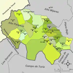
Alto Palancia | |
|---|---|
 | |
| Country | |
| Autonomous community | |
| Province | Castellón |
| Capital | Segorbe |
| Municipalities | |
| Area | |
| • Total | 965.15 km2 (372.65 sq mi) |
| Population (2019)[1] | |
| • Total | 23,753 |
| • Density | 25/km2 (64/sq mi) |
| Demonym | |
| Time zone | UTC+1 (CET) |
| • Summer (DST) | UTC+2 (CEST) |
| Largest municipality | Segorbe |
Alto Palancia (Valencian: Alt Palància) is a comarca in the province of Castellón, Valencian Community (Spain). It is part of the Spanish-speaking area in the Valencian Community.
Municipalities
The comarca is composed of 27 municipalities, listed below with their populations at the 2001 and 2011 Censuses, and according to the most recent official estimates (for 1 January 2019):

| Name | Population (2001)[2] |
Population (2011)[3] |
Population (2019)[4] |
|---|---|---|---|
| Algimia de Almonacid | 299 | 296 | 263 |
| Almedíjar | 270 | 302 | 254 |
| Altura | 3,140 | 3,784 | 3,528 |
| Azuébar | 327 | 362 | 315 |
| Barracas | 164 | 199 | 162 |
| Bejís | 370 | 418 | 380 |
| Benafer | 150 | 177 | 152 |
| Castellnovo | 1,026 | 1,045 | 917 |
| Caudiel | 704 | 736 | 664 |
| Chóvar | 369 | 355 | 288 |
| Gaibiel | 200 | 195 | 188 |
| Geldo | 703 | 690 | 635 |
| Higueras | 47 | 58 | 54 |
| Jérica | 1,561 | 1,653 | 1,548 |
| Matet | 125 | 106 | 84 |
| Navajas | 564 | 828 | 716 |
| Pavías | 59 | 61 | 61 |
| Pina de Montalgrao | 157 | 140 | 111 |
| Sacañet | 84 | 77 | 67 |
| Segorbe | 8,023 | 9,198 | 8,978 |
| Soneja | 1,383 | 1,515 | 1,447 |
| Sot de Ferrer | 407 | 442 | 415 |
| Teresa | 317 | 277 | 242 |
| Torás | 238 | 259 | 223 |
| El Toro | 291 | 283 | 256 |
| Vall de Almonacid | 279 | 267 | 269 |
| Viver | 1,307 | 1,627 | 1,536 |
| Totals | 22,564 | 25,350 | 23,753 |
References
- ↑ Official estimate as at 1 January 2019: Instituto Nacional de Estadística, Madrid, 2019.
- ↑ Census of 1 November 2001: Instituto Nacional de Estadística, Madrid, 2019.
- ↑ Census of 1 November 2011: Instituto Nacional de Estadística, Madrid, 2019.
- ↑ Official estimate as at 1 January 2019: Instituto Nacional de Estadística, Madrid, 2019.
39°51′12″N 0°29′06″W / 39.85333°N 0.48500°W
This article is issued from Wikipedia. The text is licensed under Creative Commons - Attribution - Sharealike. Additional terms may apply for the media files.