Angul district ଅନୁଗୋଳ ଜିଲ୍ଲା | |
|---|---|
  | |
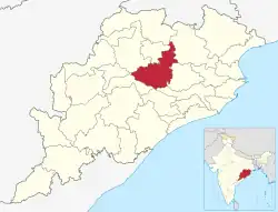 Location in Odisha | |
| Coordinates: 20°49′59″N 85°06′00″E / 20.833°N 85.1°E | |
| Country | |
| State | |
| Established | 1 April 1993 |
| Headquarters | Angul |
| Government | |
| • Type | Municipality |
| • Collector & District Magistrate | Er.Siddharth Shankar Swain, IAS |
| • Divisional Forest Officer Cum Wildlife Warden | Karthick V |
| Area | |
| • Total | 6,232 km2 (2,406 sq mi) |
| Elevation | 875.5 m (2,872.4 ft) |
| Population (2011)[1] | |
| • Total | 1,273,821 |
| • Density | 200/km2 (530/sq mi) |
| Languages | |
| • Official | Odia, English |
| Time zone | UTC+5:30 (IST) |
| PIN | 759100–759122 |
| Telephone code | 06764 |
| Vehicle registration | Angul OD-19, Talcher OD-35 |
| Nearest cities | Cuttack, Bhubaneswar, Sambalpur |
| Sex ratio | 0.942 ♂/♀ |
| Literacy | 78.96% |
| Vidhan Sabha constituency | 5 |
| Climate | Aw (Köppen) |
| Precipitation | 1,421 mm (55.9 in) |
| Average summer temperature | 47 °C (117 °F) |
| Average winter temperature | 10 °C (50 °F) |
| Website | angul |
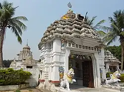
Angul district; also known as Anugul, is one of the thirty districts of Odisha in eastern India. The city of Angul is the district headquarters of Angul district.
History
Angul District, originally part of Undivided Dhenkanal, became separate on April 1, 1993, for administrative convenience. The name "Angul" of the district originates from its headquarters, Angul. According to L.S.S. O’Malley, the name is believed to be a transformation of "Anugol," with a legend attached. In the past, the region was inhabited by Khonds, Savaras, and Gonds, with Khonds being predominant. It was divided into principalities led by Khond chiefs, until the Odisha King established rule, aided by Rajputs and adventurers, over the Khonds who paid tribute. The last Khond chief, Anu, rebelled, and a conspiracy led to his deposition through a struggle called "gol." The conquerors commemorated their victory by naming the land "Anugol," which evolved into "Anugula" or "Anugol" in colloquial language.
Geography
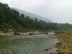
Angul is located in the centre of the state of Odisha and lies between the latitudes of 20°31′N and 21°40′N and longitudes of 84°15′E and 85°23′E. The altitude is between 564 and 1,187 metres (1,850 and 3,894 ft).[2] The district has an area of 6,232 km2 (2,406 sq mi). It is bounded by Dhenkanal and Cuttack district in the east, Deogarh, Kendujhar and Sundargarh district in north, Sambalpur and Sonepur in west and Boudh and Nayagarh in the south side. The district is abundant with natural resources. Angul, The district headquarters is about 150 kilometres (93 mi) from the state capital Bhubaneswar.
A study jointly conducted by Indian Institute of Technology, Delhi (IIT-D) and Central Pollution Control Board (CPCB) in 2010 revealed that Angul district is among the top ten most polluted Indian cities where the pollution level reached a "very alarming" level.[3]
Divisions
The following is the list of blocks, tehsils and subdivisions in the district of Angul:
Sub-division
Blocks
- Angul Sadar
- Athmallik Sadar
- Chhendipada
- Talcher Sadar
- Pallahada Sadar
- Banarpal
- Kishorenagar
- Kaniha
Tehsils
- Angul
- Athmallik
- Talcher
- Pallahada
- Chendipada
- Banarpal
- Kishorenagar
- Kaniha
Demographics
| Year | Pop. | ±% p.a. |
|---|---|---|
| 1901 | 278,144 | — |
| 1911 | 287,294 | +0.32% |
| 1921 | 250,480 | −1.36% |
| 1931 | 309,044 | +2.12% |
| 1941 | 360,714 | +1.56% |
| 1951 | 408,041 | +1.24% |
| 1961 | 500,033 | +2.05% |
| 1971 | 628,537 | +2.31% |
| 1981 | 785,734 | +2.26% |
| 1991 | 961,037 | +2.03% |
| 2001 | 1,140,003 | +1.72% |
| 2011 | 1,273,821 | +1.12% |
| source:[4] | ||
According to the 2011 census, Angul district has a population of 1,273,821,[1] ranking of 380th in India (out of a total of 640).[1] The district has a population density of 199 inhabitants per square kilometre (520/sq mi).[1] Its population growth rate over the decade 2001–2011 was 11.55%.[1] Anugul has a sex ratio of 942 females for every 1000 males,[1] and a literacy rate of 78.96%. 16.21% of the population lives in urban areas. Scheduled Castes and Scheduled Tribes make up 18.81% and 14.10% of the population respectively.[1]
At the time of the 2011 Census of India, 95.50% of the population in the district spoke Odia, 1.41% Ho and 1.30% Hindi as their first language.[6]
Politics
Legislative Assembly Constituencies
The following are the five Vidhan Sabha constituencies[7][8] of Angul district and the elected members[9] of the Angul district:
| No. | Constituency | Reservation | Extent of the Assembly Constituency (Blocks) | Member of 14th Assembly | Party |
|---|---|---|---|---|---|
| 59 | Pallahara | None | Pallahara, Kaniha (part) | Mukesh Kumar Pal | BJD |
| 60 | Talcher | None | Talcher (M), Talcher, Kaniha (part) | Braja Kishore Pradhan | BJD |
| 61 | Angul | None | Angul (M), NALCO (C. T), Angul (part), Banarpal (part) | Rajani Kant Singh | BJD |
| 62 | Chhendipada | SC | Chhendipada, Banarpal (part) | Sushanta Behera | BJD |
| 63 | Athmallik | None | Athmallik (NAC), Athmallik, Kishorenagar, Angul (part) | Ramesh Chandra Sai | BJD |
Lok Sabha constituencies
Since 2008, Angul district is represented in Dhenkanal (Lok Sabha constituency) and Sambalpur (Lok Sabha constituency).
Angul (Lok Sabha constituency) does not exist in 1952 general elections to 1st Lok Sabha. However it is created from 2nd till 5th Lok Sabha during 1957 till 1976. Badakumar Pratap Gangadeb got elected in 1957 and 1971 for 2nd and 5th Lok Sabha while Harekrushna Mahatab was elected in 1962 to 3rd and D. N. Deb was elected in 1967 to 4th Lok Sabha. Angul Seat ceased after the creation of Deogarh (Lok Sabha constituency) in 1977 from 6th Lok Sabha. Deogarh seat was also delimited in 2008.[10]
Natural resources and coal mines
Angul district has the Radhikapur West coal block which is known for its good quality coal.[11] In December 2020, the coal mines were auctioned for supplying to an Aluminium Smelter plant in Jharsuguda.[12]
References
- 1 2 3 4 5 6 7 "District Census Handbook 2011 - Angul" (PDF). Census of India. Registrar General and Census Commissioner of India.
- ↑ "Census of India 2001: Data from the 2001 Census, including cities, villages and towns (Provisional)". Census Commission of India. Archived from the original on 16 June 2004. Retrieved 1 November 2008.
- ↑ "Angul-Talcher seventh most polluted industrial cluster in the country". The Hindu. 5 January 2010.
- ↑ Decadal Variation In Population Since 1901
- ↑ "Table C-01 Population by Religious Community: Odisha". Census of India, 2011. Registrar General and Census Commissioner of India.
- 1 2 "Table C-16 Population by Mother Tongue: Odisha". Census of India 2011. Registrar General and Census Commissioner of India.
- ↑ "Assembly Constituencies and their EXtent" (PDF). Archived (PDF) from the original on 5 March 2016. Retrieved 28 February 2013.
- ↑ "Seats of Odisha". Archived from the original on 5 March 2016. Retrieved 28 February 2013.
- ↑ "List of Member in Fourteenth Assembly". ws.ori.nic.in. Archived from the original on 2 May 2007. Retrieved 19 February 2013.
MEMBER NAME
- ↑ "All Members of Lok Sabha (Since 1952) Members Biographical Sketches". Archived from the original on 29 July 2017. Retrieved 21 December 2017.
- ↑ "Radhikapur (West) coal mine". 30 April 2021.
- ↑ Market, Capital (31 December 2020). "Vedanta wins Radhikapur West Coal Block". Business Standard India. Retrieved 31 December 2020.
Bibliography
- O'Malley, L.S.S. (1908). Bengal District Gazetteers – Angul. Archived from the original on 12 August 2023. Retrieved 12 August 2023.
{{cite book}}: CS1 maint: bot: original URL status unknown (link) - Taradatt, Dr. (ed.). Odisha district gazetteers – Angul (PDF). Gopabandhu Academy of Administration [Gazetteers Unit], General Administration Department, Government of Odisha. Archived (PDF) from the original on 20 December 2016.
External links
Places adjacent to Angul district | |
|---|---|
