Ardabil Province
استان اردبیل | |
|---|---|
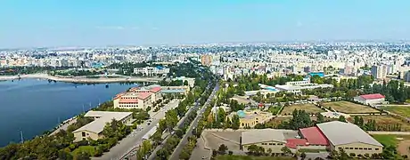
 The city of Ardabil | |
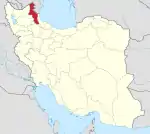
 Location of Ardabil province within Iran | |
| Coordinates: 38°26′N 48°06′E / 38.433°N 48.100°E | |
| Country | Iran |
| Region | Region 3 |
| Capital | Ardabil |
| Counties | 12 |
| Government | |
| • Governor-general | Hamed Ameli |
| • MPs of Assembly of Experts | Hassan Ameli and Fakhreddin Mousavi |
| • Representative of the Supreme Leader | Hassan Ameli |
| Area | |
| • Total | 17,800 km2 (6,900 sq mi) |
| Population (2016) | |
| • Total | 1,270,420 |
| • Density | 71/km2 (180/sq mi) |
| Time zone | UTC+03:30 (IRST) |
| Main language(s) | Persian (official) local languages: Azerbaijani (Majority) Tati Talysh |
| HDI (2017) | 0.756[1] high · 28th |
Ardabil Province (Persian: استان اردبیل; Azerbaijani: اردبیل اوستانی) is one of the 31 provinces of Iran. It is in the northwest of the country, in Region 3, bordering the Republic of Azerbaijan, and the provinces of East Azerbaijan, Zanjan, and Gilan.[2] Its administrative centre is the city of Ardabil. The province, spanning an area of 18,011 km2, and established in 1993, was carved out of the eastern part of East Azerbaijan.
At the time of the 2006 National Census, the province had a population of 1,209,968 in 281,433 households.[3] The following census in 2011 counted 1,248,488 people in 337,943 households.[4] According to the National Census of 2016, the population of Ardabil province had risen to 1,270,420 inhabitants in 377,423 households.[5]
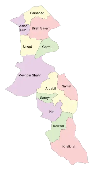
Administrative divisions

| Administrative Divisions | 2006[3] | 2011[4] | 2016[5] |
|---|---|---|---|
| Ardabil County | 542,930 | 564,365 | 605,992 |
| Aslan Duz County1 | — | — | — |
| Bileh Savar County | 54,471 | 53,768 | 51,404 |
| Germi County | 89,248 | 84,267 | 76,901 |
| Khalkhal County | 92,315 | 92,332 | 86,731 |
| Kowsar County | 27,472 | 26,198 | 22,127 |
| Meshgin Shahr County | 156,141 | 151,156 | 149,941 |
| Namin County | 59,242 | 61,333 | 60,659 |
| Nir County | 23,573 | 23,656 | 20,864 |
| Parsabad County | 164,576 | 173,182 | 177,601 |
| Sareyn County2 | — | 18,231 | 18,200 |
| Ungut County3 | — | — | — |
| Total | 1,209,968 | 1,248,488 | 1,270,420 |
| 1Separated from Parsabad County in 2017.[6] 2Separated from Ardabil County 3Separated from Germi County in 2020 | |||
Cities
According to the 2016 census, 866,034 people (over 68% of the population of Ardabil province) live in the following cities: Abi Beyglu 6,516, Anbaran 5,757, Ardabil 529,374, Aslan Duz 6,348, Bileh Savar 16,188, Eslamabad 3,068, Fakhrabad 999, Germi 28,967, Hashatjin 5,725, Hir 2,080, Jafarabad 7,226, Khalkhal 39,304, Kivi 7,101, Kolowr 2,347, Kuraim 831, Lahrud 2,149, Meshginshahr 74,109, Moradlu 671, Namin 13,659, Nir 5,873, Parsabad 93,387, Qosabeh 2,095, Razey 1,581, Sareyn 5,459, Tazeh Kand-e Angut 2,645, and Tazeh Kand-e Qadim 2,575.[5]
Geography
Many tourists come to the region for its cool climate (max 35 °C (95°F)) during the hot summer months. The winters are bitterly cold, with temperatures plummeting to −25 °C (-13°F).
Its famous natural region is the Sabalan mountains. The province is considered the coldest province in Iran by many. Large parts of the province are green and forested.
Ardabil's capital stands about 70 km from the Caspian Sea. Neighboring the Caspian Sea and the Republic of Azerbaijan, the city is of political and economic significance.
History

The natural features of the province of Ardabil are mentioned in the Avesta, according to which Zoroaster was born by the river Aras and wrote his book in the Sabalan Mountains. During the Islamic conquest of Iran, Ardabil was the largest city in Azarbaijan, and remained so until the Mongol invasion period.
Shah Ismail I started his campaign to nationalize Iran's government and land from here, but consequently announced Tabriz as his capital in 1500 CE. Yet Ardabil remained an important city both politically and economically until modern times.
Culture
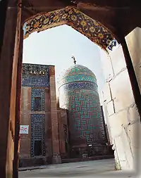
Ardabil is the seat of the sanctuary and tomb of Shaikh Safî ad-Dîn, eponym of the Safavid dynasty Kulliye. It has many hot springs and natural landscapes which attract tourists. The mineral springs of Ardabil are Beele-Darreh, Sareyn, Sardabeh and Booshloo, which are known throughout Iran for their medicinal qualities. It also has a number of lakes: the largest of which are Ne'or, Shoorabil, ShoorGel, NouShahr and Alooche, which are the habitats of some species of water birds.
Lake Ne'or is located in a mountainous area 48 km south-east of the city of Ardabil. It covers an area of 2.1 km2 and has an average depth of 3 metres. It is fed by springs in the lake bed. Lake Shoorabil is located in a hilly area south of the city of Ardabil and covers an area of 640,000 m2. The surface of the lake is covered with a thin white layer of minerals, which is useful for healing skin diseases and rheumatism. Near the lake there is the leisure complex of Shoorabil. Ardabil is a city of great antiquity. Its origins go back 4000 to 6000 years (according to historical research in this city). This city was the capital of Azerbaijan province in different times, but its golden age was in the Safavid period.
One of the most ancient cities in Iran is Meshkin Shahr. It is located in the north-west of Iran in Azerbaijan, 839 kilometers from Tehran. It is the closest city to the Sabalan mountains. In the past, it was called "Khiav", "Orami", and "Varavi".
Colleges and universities
- Ardabil University of Medical Sciences
- Mohaghegh Ardabili University
- Islamic Azad University of Ardabil
- Payam Noor University of Ardabil
- Soureh University of Ardabil
- Islamic Azad University of Khalkhal
Language
The primary language of Ardabil province is Azerbaijani, a Turkic language.[7][8][9] Other languages in Ardabil include Tati and Talysh. In and around Khalkhal, there is a significant group of Kurmanji-speaking Kurds known as Gormanj.[10] [11]
See also
References
- ↑ "Sub-national HDI - Area Database - Global Data Lab". hdi.globaldatalab.org. Retrieved 2018-09-13.
- ↑ "همشهری آنلاین-استانهای کشور به ۵ منطقه تقسیم شدند (Provinces were divided into 5 regions)". Hamshahri Online (in Persian). 22 June 2014 [1 Tir 1393, Jalaali]. Archived from the original on 23 June 2014.
- 1 2 "Census of the Islamic Republic of Iran, 1385 (2006)". AMAR (in Persian). The Statistical Center of Iran. p. 24. Archived from the original (Excel) on 20 September 2011. Retrieved 25 September 2022.
- 1 2 "Census of the Islamic Republic of Iran, 1390 (2011)" (Excel). Iran Data Portal (in Persian). The Statistical Center of Iran. p. 24. Retrieved 19 December 2022.
- 1 2 3 "Census of the Islamic Republic of Iran, 1395 (2016)". AMAR (in Persian). The Statistical Center of Iran. p. 24. Archived from the original (Excel) on 22 March 2019. Retrieved 19 December 2022.
- ↑ Jahangiri, Ishaq (24 March 2017). "Approval letter regarding country divisions in Parsabad County of Ardabil province". Islamic Parliament Research Center of the Islamic Republic of Iran (in Persian). Ministry of Interior. Archived from the original on 15 March 2019. Retrieved 26 March 2023.
- ↑ Iran A Country Study, Author Federal Research Division, Edition reprint, Publisher Kessinger Publishing, 2004, ISBN 1-4191-2670-9, ISBN 978-1-4191-2670-3, Length 340 pages
- ↑ Encyclopedia of the Stateless Nations: S-Z Volume 4 of Encyclopedia of the Stateless Nations: Ethnic and National Groups Around the World, James Minahan, ISBN 0-313-31617-1, ISBN 978-0-313-31617-3, Author James Minahan, Publisher Greenwood Publishing Group, 2002, ISBN 0-313-32384-4, ISBN 978-0-313-32384-3, Length 2241 pages
- ↑ "CIAO". Archived from the original on 2007-12-01. Retrieved 2013-07-09.
- ↑ "گذری بر تاریخچه کُردهای خلخال".
- ↑ "Talysh".
External links
- Encyclopedia of Orient About Ardabil Archived 2019-12-31 at the Wayback Machine
- "Ardabil-Iran Carvan Tourism". Archived from the original on March 29, 2006. Retrieved October 27, 2005.
- Ardabil entries in the Encyclopædia Iranica
- "site of meshkin shahr". Archived from the original on July 16, 2008. Retrieved October 30, 2009.
