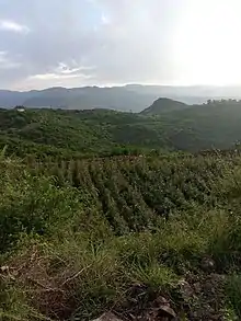
Al-Saḥūl (Arabic: وادي السحول) is both a town and a wadi located between the city of Ibb and al-Makhadir District in Ibb Governorate, Yemen. It was known as Mikhlaf as-Saḥūl, "mikhlaf" being the name of administrative divisions in ancient Yemen. Al-Sahul was called Miṣr al-Yaman (The Egypt of Yemen) because of its abundance of corn. It is famous for its inhabitants' white cotton clothes, the Saḥūlīyya or Saḥūlī.[1][2] According to Hadith, the Islamic prophet Muhammad was "shrouded in three Saḥūlī white cotton garments none of which was a long shirt or turban."[3][4][1] According to the British orientalist James Heyworth-Dunne, As-Saḥūl was also known globally for its "exquisite striped cloaks".[5]
The As-Saḥūl Valley is inhabited by the Sharʿab tribe, the Waḥaḍah tribe, and clans of al-Kalaʿ.[6]
Mikhlaf As-Saḥūl previously had other names, such as "Mikhlaf Ja'far" after Ja'far al-Manakhi, the founder of the Manakhis Emirate, and "Mikhlaf al-Kalaʿ".[6]
References
- 1 2 Donzel, E. van (2012-04-24). "al-Saḥūl". Encyclopaedia of Islam, Second Edition.
- ↑ Lamm, Carl Johan (1937). Cotton in Mediaeval Textiles of the Near East. P. Geuthner.
- ↑ Lecker, Michael (January 1998). Jews and Arabs in Pre- and Early Islamic Arabia. Ashgate. ISBN 978-0-86078-784-6.
- ↑ Bulliet, Richard W. (2011). Cotton, Climate, and Camels in Early Islamic Iran: A Moment in World History. Columbia University Press. ISBN 978-0-231-14837-5.
- ↑ Heyworth-Dunne, J (1952). Al-Yemen: a general social, political & economic survey. p. 54. OCLC 2997076.
- 1 2 الهمدانى, ابى محمد الحسن بن احمد بن يعقوب (1990). صفة جزيرة العرب (in Arabic). ktab INC. p. 201.
14°05′18″N 44°10′35″E / 14.0883°N 44.1765°E