| Bader Glacier | |
|---|---|
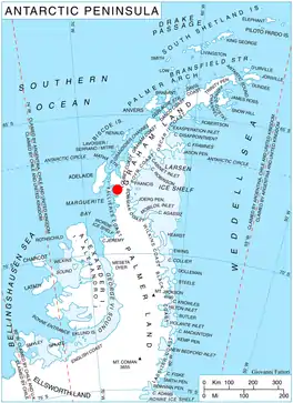
 Location of German Peninsula in Graham Land, Antarctic Peninsula | |
 Location of Bader Glacier in Antarctica | |
| Location | German Peninsula |
| Coordinates | 63°37′S 66°45′W / 63.617°S 66.750°W |
| Thickness | unknown |
| Highest elevation | 574 m (1,883 ft) |
| Terminus | Bourgeois Fjord |
| Status | unknown |
Bader Glacier (67°37′S 66°45′W / 67.617°S 66.750°W) is a small glacier draining the west slopes of Rudozem Heights and flowing to Bourgeois Fjord just south of Thomson Head on German Peninsula, Fallières Coast on the west side of Graham Land, Antarctica.
History
It was named by the UK Antarctic Place-Names Committee in 1958 for Swiss glaciologist Henri Bader of Rutgers University (U.S.), author of an important thesis on the development of the snowflake and its metamorphoses.
See also
Map
- British Antarctic Territory. Scale 1:200000 topographic map. DOS 610 Series, Sheet W 67 66. Directorate of Overseas Surveys, Tolworth, UK, 1978.
References
 This article incorporates public domain material from "Bader Glacier". Geographic Names Information System. United States Geological Survey.
This article is issued from Wikipedia. The text is licensed under Creative Commons - Attribution - Sharealike. Additional terms may apply for the media files.