Casement Aerodrome Aeradróm Mhic Easmainn | |||||||||||||||
|---|---|---|---|---|---|---|---|---|---|---|---|---|---|---|---|
 | |||||||||||||||
 | |||||||||||||||
| Summary | |||||||||||||||
| Airport type | Military | ||||||||||||||
| Owner | Department of Defence | ||||||||||||||
| Operator | Irish Air Corps | ||||||||||||||
| Location | Baldonnel, Dublin, Ireland | ||||||||||||||
| Elevation AMSL | 319 ft / 97 m | ||||||||||||||
| Coordinates | 53°18′06″N 06°27′04″W / 53.30167°N 6.45111°W | ||||||||||||||
| Website | Air Corps | ||||||||||||||
| Map | |||||||||||||||
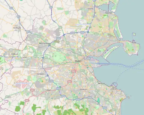
 EIME Location of airport in County Dublin  EIME Location of airport in Ireland | |||||||||||||||
| Runways | |||||||||||||||
| |||||||||||||||
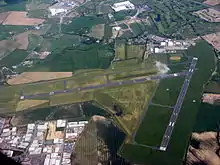
Casement Aerodrome (Irish: Aeradróm Mhic Easmainn) or Baldonnel Aerodrome (ICAO: EIME) is a military airbase to the southwest of Dublin, Ireland situated off the N7 main road route to the south and south west. It is the headquarters and the sole airfield of the Irish Air Corps, and is also used for other government purposes.
The airport is the property of the Irish Department of Defence. Baldonnel Aerodrome is also the home of the Garda Air Support Unit.[1]
History
The airfield was first laid out in 1917 and was used by the Royal Flying Corps (soon to become the Royal Air Force). It was part of the RAF's Ireland Command.
In 1919, civilian flights commenced, with a service from London.
The aerodrome was originally run by two pilots from the Royal Air Force. The airfield was the one from which the first successful east–west Atlantic crossing by a Junkers W33 aeroplane, the Bremen, took off on 12 April 1928 with Baron Hünefeld, Hermann Köhl and Captain James Fitzmaurice as co-pilot;[2] and the first Aer Lingus flight took place from here on 27 May 1936.[3] It was also the destination at which Douglas Corrigan landed on his famous 'wrong way' flight across the Atlantic on 18 July 1938.[4]
In February 1965 Baldonnel was renamed Casement Aerodrome in honour of the Irish nationalist Roger Casement, executed for treason by the British in 1916.[5]
In 1995 it was suggested that it be used as a second commercial airport for Dublin, especially for low-cost carriers such as Ryanair.[6]
Anti-war activists have accused the government of allowing the aerodrome's use as a US military stopover hub, with protests in 2006 leading to arrests.[7] In March 2002, Michael Smith, the Minister for Defence, confirmed that since September 2001, 22 US military aircraft had landed at the aerodrome.[8] There has also been speculation since the early 2000s that Casement Aerodrome is used as an airport by the Central Intelligence Agency (CIA) for their extraordinary rendition programme. Similar claims have been made with regard to Shannon Airport, but as Baldonnel is a military airport, it is impossible to verify.[9]
Queen Elizabeth II landed at Casement Aerodrome on 17 May 2011, beginning her state visit to Ireland.[10]
Climate
| Climate data for Dublin (Casement), 1981–2010 normals, extremes 1958–present | |||||||||||||
|---|---|---|---|---|---|---|---|---|---|---|---|---|---|
| Month | Jan | Feb | Mar | Apr | May | Jun | Jul | Aug | Sep | Oct | Nov | Dec | Year |
| Record high °C (°F) | 15.4 (59.7) |
15.9 (60.6) |
21.0 (69.8) |
22.7 (72.9) |
24.9 (76.8) |
27.6 (81.7) |
31.9 (89.4) |
30.5 (86.9) |
25.4 (77.7) |
23.4 (74.1) |
17.7 (63.9) |
15.4 (59.7) |
31.9 (89.4) |
| Mean daily maximum °C (°F) | 8.0 (46.4) |
8.2 (46.8) |
10.2 (50.4) |
12.4 (54.3) |
15.2 (59.4) |
17.9 (64.2) |
19.8 (67.6) |
19.5 (67.1) |
17.1 (62.8) |
13.6 (56.5) |
10.2 (50.4) |
8.3 (46.9) |
13.4 (56.1) |
| Daily mean °C (°F) | 5.1 (41.2) |
5.1 (41.2) |
6.8 (44.2) |
8.2 (46.8) |
10.9 (51.6) |
13.6 (56.5) |
15.7 (60.3) |
15.4 (59.7) |
13.3 (55.9) |
10.3 (50.5) |
7.2 (45.0) |
5.4 (41.7) |
9.7 (49.5) |
| Mean daily minimum °C (°F) | 2.1 (35.8) |
2.0 (35.6) |
3.3 (37.9) |
4.1 (39.4) |
6.6 (43.9) |
9.4 (48.9) |
11.5 (52.7) |
11.3 (52.3) |
9.5 (49.1) |
7.0 (44.6) |
4.2 (39.6) |
2.4 (36.3) |
6.1 (43.0) |
| Record low °C (°F) | −13.2 (8.2) |
−10.3 (13.5) |
−9.8 (14.4) |
−5.5 (22.1) |
−3.0 (26.6) |
−0.7 (30.7) |
2.5 (36.5) |
1.5 (34.7) |
−0.3 (31.5) |
−4.1 (24.6) |
−9.1 (15.6) |
−15.7 (3.7) |
−15.7 (3.7) |
| Average precipitation mm (inches) | 63.8 (2.51) |
48.5 (1.91) |
50.7 (2.00) |
51.9 (2.04) |
59.1 (2.33) |
62.5 (2.46) |
54.2 (2.13) |
72.3 (2.85) |
60.3 (2.37) |
81.6 (3.21) |
73.7 (2.90) |
75.7 (2.98) |
754.2 (29.69) |
| Average precipitation days (≥ 1.0 mm) | 12 | 10 | 11 | 10 | 11 | 10 | 10 | 11 | 10 | 12 | 11 | 12 | 130 |
| Average snowy days | 4.1 | 3.9 | 2.5 | 1.1 | 0.1 | 0.0 | 0.0 | 0.0 | 0.0 | 0.0 | 0.5 | 2.3 | 14.6 |
| Average relative humidity (%) (at 15:00 UTC) | 82.2 | 76.7 | 71.8 | 67.7 | 67.3 | 67.9 | 68.9 | 69.0 | 71.8 | 76.6 | 81.6 | 84.1 | 73.8 |
| Mean monthly sunshine hours | 52.7 | 70.6 | 102.3 | 153.0 | 186.0 | 159.0 | 151.9 | 148.8 | 123.0 | 102.3 | 66.0 | 46.5 | 1,362.1 |
| Mean daily sunshine hours | 1.7 | 2.5 | 3.3 | 5.1 | 6.0 | 5.3 | 4.9 | 4.8 | 4.1 | 3.3 | 2.2 | 1.5 | 3.7 |
| Source: Met Éireann[11][12][13] | |||||||||||||
.jpg.webp)
See also
References
- ↑ "Air Support Unit - An Garda Síochána - Ireland's National Police Service". Archived from the original on 16 April 2014. Retrieved 30 June 2013.
- ↑ "Casement Aerodrome: History". Met Éireann. 2011. Archived from the original on 6 March 2012. Retrieved 7 February 2011.
- ↑ "Aer Lingus Group plc - Company History". FundingUniverse LLC. Archived from the original on 20 October 2012. Retrieved 6 November 2010.
- ↑ Sears, Stan (March 2005). "Corrigan's Way: Right or Wrong, He Made His Mark on History". Airport Journals. Archived from the original on 17 November 2016. Retrieved 16 November 2016.
- ↑ Comdt Peter Tormey & Capt Kevin Byrne, Irish Air Corps: A View from the Tower, Defence Forces Printing Press 1991
- ↑ McConnell, Daniel (14 January 2007). "Minister Kenny rejected plan for second airport". Irish Independent. Archived from the original on 17 November 2016. Retrieved 6 November 2010.
- ↑ (Irish Times, 18/4/06)
- ↑ Healy, Alison (19 March 2003). "TDs call for free vote on Shannon issue". Irish Times. Archived from the original on 20 December 2016. Retrieved 6 November 2010.
- ↑ "Norris: CIA 'using Baldonnel airport'". Breaking News ie. 20 December 2005. Archived from the original on 17 November 2016. Retrieved 10 May 2014.
- ↑ "Queen begins first state visit to Republic of Ireland". BBC News. 17 May 2011. Retrieved 12 September 2022.
- ↑ "Casement Airport 1981–2010 averages". Met Éireann. Retrieved 13 October 2016.
- ↑ "Absolute Maximum Air Temperatures for each Month at Selected Stations" (PDF). Met Éireann. Archived from the original (PDF) on 4 March 2016. Retrieved 13 October 2016.
- ↑ "Absolute Minimum Air Temperatures for each Month at Selected Stations" (PDF). Met Éireann. Archived from the original (PDF) on 29 January 2017. Retrieved 13 October 2016.

