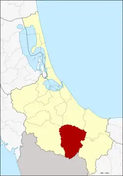
Na Thawi
นาทวี | |
|---|---|
 District location in Songkhla province | |
| Coordinates: 6°44′30″N 100°41′31″E / 6.74167°N 100.69194°E | |
| Country | Thailand |
| Province | Songkhla |
| Area | |
| • Total | 747.0 km2 (288.4 sq mi) |
| Population (2022) | |
| • Total | 69,407 |
| • Density | 78.5/km2 (203/sq mi) |
| Time zone | UTC+7 (ICT) |
| Postal code | 90160 |
| Geocode | 9004 |
Na Thawi (Thai: นาทวี, pronounced [nāː tʰā.wīː]; Pattani Malay: นาวี, pronounced [nāːwīː]) is a district (amphoe) in the southern part of Songkhla province, southern Thailand.
History
The area of Na Thawi was separated from Chana district and made a minor district (king amphoe) in 1957.
Geography
Neighboring districts are (from the west clockwise): Sadao, Chana, Thepha, and Saba Yoi. To the south is the state of Kedah, Malaysia.
Administration
The district is divided into 10 sub-districts (tambons), which are further subdivided into 92 villages (mubans). The township (thesaban tambon) Na Thawi covers parts of tambon Na Thawi. There are a further 10 tambon administrative organizations (TAO).
| No. | Name | Thai name | Villages | Pop. | |
|---|---|---|---|---|---|
| 1. | Na Thawi | นาทวี | 17 | 16,678 | |
| 2. | Chang | ฉาง | 9 | 5,033 | |
| 3. | Na Mo Si | นาหมอศรี | 8 | 3,115 | |
| 4. | Khlong Sai | คลองทราย | 8 | 6,055 | |
| 5. | Plak Nu | ปลักหนู | 7 | 5,098 | |
| 6. | Tha Pradu | ท่าประดู่ | 9 | 5,923 | |
| 7. | Sathon | สะท้อน | 10 | 7,682 | |
| 8. | Thap Chang | ทับช้าง | 10 | 7,115 | |
| 9. | Prakop | ประกอบ | 7 | 7,036 | |
| 10. | Khlong Kwang | คลองกวาง | 7 | 5,645 |
External links
- amphoe.com (in Thai)
This article is issued from Wikipedia. The text is licensed under Creative Commons - Attribution - Sharealike. Additional terms may apply for the media files.