Banggai Sea Regency
Kabupaten Banggai Laut | |
|---|---|
 Coat of arms | |
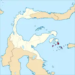 Location within Central Sulawesi | |
| Coordinates: 1°35′20″S 123°30′03″E / 1.5888°S 123.5008°E | |
| Country | Indonesia |
| Province | Central Sulawesi |
| Capital | Banggai |
| Government | |
| • Regent | Wenny Bukamo |
| • Vice Regent | Tuty Hamid |
| Area | |
| • Total | 280.18 sq mi (725.67 km2) |
| Population (mid 2022 estimate) | |
| • Total | 71,350 |
| • Density | 250/sq mi (98/km2) |
| [1] | |
| Time zone | UTC+8 (ICST) |
| Area code | (+62) 461 |
| Website | banggailautkab |
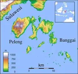

Banggai Sea Regency (Indonesian: Kabupaten Banggai Laut) is a regency in the province of Central Sulawesi, Indonesia. The regency was established on 14 December 2012, partitioned from the Banggai Islands Regency.[2] It comprises southern part of the Banggai Islands archipelago, including the main island of Banggai itself (including 40 offshore islets), the islands of Labobo and Bangkurung to the southwest of Banggai Island, and the numerous small Bokan Islands (Kepulauan Bokan) to the southeast. It covers a land area of 725.67 km2, and the districts now comprising the new Regency had a population of 62,183 at the 2010 Census[3] and 70,435 at the 2020 Census;[4] the official estimate as at mid 2022 was 71,350.[1]
Administration
The new Banggai Laut Regency is composed of seven districts (kecamatan), tabulated below with their areas and their 2010 Census[3] and 2020 Census populations,[4] together with the official estimates as at mid 2021.[5] The table also includes the location of the district headquarters, the number of administrative villages in each district (in total, 63 rural desa and 3 urban kelurahan), and its postal codes.
| Kode Wilayah | Name of District (kecamatan) | Area in km2 | Pop'n Census 2010 | Pop'n Census 2020 | Pop'n Estimate mid 2021 | Admin centre | No. of villages | Post codes |
|---|---|---|---|---|---|---|---|---|
| 72.11.04 | Bangkurung (island) | 116.55 | 8,196 | 8,928 | 8,940 | Lantibung | 12 (a) | 94892 |
| 72.11.05 | Labobo (island) (b) | 85.65 | 5,241 | 6,036 | 6,070 | Mansaleang | 8 | 94893 |
| 72.11.02 | Banggai Utara (North Banggai) | 58.05 | 6,007 | 7,042 | 7,100 | Lokotoy | 6 | 94896 |
| 72.11.01 | Banggai (district) (c) | 86.95 | 19,977 | 22,591 | 22,720 | Lompio | 10 | 94891 |
| 72.11.07 | Banggai Tengah (Central Banggai) | 68.19 | 6,362 | 7,902 | 8,020 | Adean | 8 | 94895 |
| 72.11.06 | Banggai Selatan (South Banggai) | 81.20 | 4,809 | 5,803 | 5,870 | Matanga | 6 | 94890 |
| 72.11.03 | Bokan Kepulauan (d) (Bokan Islands) | 229.08 | 11,571 | 12,133 | 12,110 | Bungin | 16 | 94894 |
| Totals | 725.67 | 62,163 | 70,435 | 70,872 | 66 |
Notes: (a) including three kelurahan - Dodung, Lompio, and Tano Bonunungan. (b) including 10 small offshore islands. (c) including 42 small offshore islands. (d) comprising 91 islands.
Climate
Banggai has a tropical rainforest climate (Af) with moderate rainfall from September to December and heavy to very heavy rainfall from January to August.
| Climate data for Banggai | |||||||||||||
|---|---|---|---|---|---|---|---|---|---|---|---|---|---|
| Month | Jan | Feb | Mar | Apr | May | Jun | Jul | Aug | Sep | Oct | Nov | Dec | Year |
| Mean daily maximum °C (°F) | 30.7 (87.3) |
30.8 (87.4) |
30.9 (87.6) |
31.2 (88.2) |
30.8 (87.4) |
30.3 (86.5) |
29.8 (85.6) |
30.5 (86.9) |
31.2 (88.2) |
31.8 (89.2) |
32.1 (89.8) |
31.2 (88.2) |
30.9 (87.7) |
| Daily mean °C (°F) | 26.8 (80.2) |
26.9 (80.4) |
27.0 (80.6) |
27.2 (81.0) |
27.1 (80.8) |
26.7 (80.1) |
26.2 (79.2) |
26.5 (79.7) |
26.7 (80.1) |
27.0 (80.6) |
27.7 (81.9) |
27.2 (81.0) |
26.9 (80.5) |
| Mean daily minimum °C (°F) | 23.0 (73.4) |
23.0 (73.4) |
23.1 (73.6) |
23.2 (73.8) |
23.5 (74.3) |
23.2 (73.8) |
22.7 (72.9) |
22.5 (72.5) |
22.3 (72.1) |
22.3 (72.1) |
23.4 (74.1) |
23.2 (73.8) |
23.0 (73.3) |
| Average rainfall mm (inches) | 137 (5.4) |
164 (6.5) |
209 (8.2) |
249 (9.8) |
286 (11.3) |
361 (14.2) |
238 (9.4) |
149 (5.9) |
121 (4.8) |
96 (3.8) |
100 (3.9) |
103 (4.1) |
2,213 (87.3) |
| Source: Climate-Data.org[6] | |||||||||||||
References
- 1 2 Badan Pusat Statistik, Jakarta, 2023, Kabupaten Banggai Laut Dalam Angka 2023 (Katalog-BPS 1102001.7211)
- ↑ "Malaka Akhirnya Menjadi Daerah Otonom Baru". Kompas. Retrieved 30 December 2012.
- 1 2 Biro Pusat Statistik, Jakarta, 2011.
- 1 2 Badan Pusat Statistik, Jakarta, 2021.
- ↑ Badan Pusat Statistik, Jakarta, 2022.
- ↑ "Climate: Banggai". Climate-Data.org. Retrieved 19 November 2020.
Regencies and cities of Central Sulawesi | ||
|---|---|---|
Capital: Palu | ||
| Regencies | ||
| Cities | ||