Route 360 | ||||
|---|---|---|---|---|
| Bay d'Espoir Highway | ||||
 | ||||
| Route information | ||||
| Maintained by Newfoundland and Labrador Department of Transportation and Infrastructure | ||||
| Length | 204 km (127 mi) | |||
| Major junctions | ||||
| South end | Harbour Breton | |||
| ||||
| North end | ||||
| Location | ||||
| Country | Canada | |||
| Province | Newfoundland and Labrador | |||
| Highway system | ||||
|
| ||||
| ||||
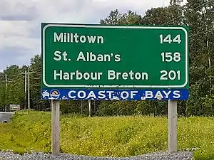
Route 360, also known as Bay d'Espoir Highway, is a provincial highway in Newfoundland and Labrador. It runs from the Bishop's Falls area to Bay d'Espoir and Harbour Breton. The road is very isolated for at least 140 kilometres (87 mi), where there are no communities or stops to refuel.[1] Bishop's Falls and Harbour Breton are the only two settlements of any size along the entire length of Route 360,[2] with other towns and communities being along the other highways it intersects.[3][4]
Cell phone reception along Route 360 is severely limited.[5][6] In 2022, Route 360 was voted the second Worst Road in Atlantic Canada by the Canadian Automobile Association's Worst Roads list.[7]
Route description
Route 360 begins as Southside Drive in Harbour Breton at a dead end along the coast of Fortune Bay. It winds its way west through neighbourhoods before bypassing downtown along Canada Drive. The highway now leaves Harbour Breton and winds its way northward up the entire length of the Connaigre Peninsula to have an intersection with Route 364 (Hermitage River Road). Route 360 heads up the Hermitage River Valley to pass by Hardy's Cove and have an intersection with Route 362 (Belleoram Road) before winding its way through remote, scenic, and hilly terrain for the next several kilometres. The highway now passes by Jipujijkuei Kuespem Provincial Park and has intersections with Route 365 (Conne River Road) and Route 361 (St. Alban's Road), where it crosses the Conne River before heading through remote wilderness for the next 140 kilometres (87 mi), where the highway crosses the Northwest Gander River. Route 360 now enters the outskirts of Bishop's Falls, where the comes to an end at an intersection with Route 1 (Trans-Canada Highway).
Major intersections

| Location | km | mi | Destinations | Notes | |
|---|---|---|---|---|---|
| Harbour Breton | 0.0 | 0.0 | Dead End | Southern terminus | |
| | 29.3 | 18.2 | Northern terminus of Route 364; provides access to the | ||
| Hardy's Cove | 34.5 | 21.4 | Hardy's Cove Road - Hardy's Cove | ||
| | 42.2 | 26.2 | Northern terminus of Route 362; provides access to | ||
| | 71.1 | 44.2 | Jipujijkuei Kuespem Provincial Park main entrance | Access road into park | |
| | 73.3 | 45.5 | Northern terminus of Route 365 | ||
| | 77.0 | 47.8 | Eastern terminus of Route 361 | ||
| Bishop's Falls | 204 | 127 | Northern terminus | ||
| 1.000 mi = 1.609 km; 1.000 km = 0.621 mi | |||||
See also
References
- ↑ "The road to Bay d'Espoir". Cape Breton Post. 4 Aug 2016. Retrieved 14 Aug 2022.
- ↑ "Touring Newfoundland's Connaigre Peninsula". Cape Breton Post. Saltwire Network. November 17, 2016. Archived from the original on 7 July 2019. Retrieved October 21, 2019.
- ↑ Google (February 23, 2020). "Route 360" (Map). Google Maps. Google. Retrieved February 23, 2020.
- ↑ "Bay d'Espoir highway closed after lightning sparks forest fires in central". CBC News. 24 Jul 2022. Retrieved 14 Aug 2022.
- ↑ "Petition to improve cell service on Bay d'Espoir highway gaining traction". NTV News. 24 August 2021. Archived from the original on 2021-08-25. Retrieved 14 Aug 2022.
- ↑ "Petition to Bring Cell Service to Bay d'Espoir Highway Picking Up Steam". VOCM. 20 Sep 2021. Retrieved 14 Aug 2022.
- ↑ "State of disrepair". Cape Breton Post. 20 Apr 2022. Retrieved 14 Aug 2022.
