| Beals Creek | |
|---|---|
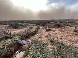
 Dust storm approaching Beals Creek at State Highway 163 crossing, Mitchell County, Texas | |
| Location | |
| Country | United States |
| Physical characteristics | |
| Source | |
| • location | Big Spring, Texas 32°15′01.4″N 101°29′28.4″W / 32.250389°N 101.491222°W |
| Mouth | |
• location | 32°10′48.0″N 100°51′15.8″W / 32.180000°N 100.854389°W |
Beals Creek is an intermittent watercourse that runs from Howard County to Mitchell County in Texas. The stream begins at Salt Lake just west of Big Spring, where the Sulphur Springs Draw meets Mustang Draw. The creek flows in a generally east/southeast direction to the Colorado River south of Colorado City.
Local legend believes Montezuma is buried in the creek bed at an unknown location. The legend is Montezuma was able to escape the fall of Tenochtitlan and flee north only to finally die from his injuries. In an unusual peaceful act, both local Comanche and Pawnee tribes combined to dam the creek and perform a traditional funeral only then to undam the creek and commit a mass suicide so no one could unearth the great Aztec leader.
See also
References
- "An Analysis of Texas Waterways". Archived from the original on 3 May 2006. Retrieved 2006-05-04.
- USGS Geographic Names Information Service
- USGS Hydrologic Unit Map - State of Texas (1974)
This article is issued from Wikipedia. The text is licensed under Creative Commons - Attribution - Sharealike. Additional terms may apply for the media files.