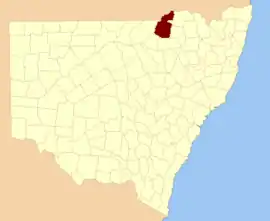
Benarba
New South Wales
Location in New South Wales
Lands administrative divisions around Benarba:
Queensland Queensland Stapylton
Finch Benarba Courallie
Denham Jamison Courallie

Benarba County is one of the 141 Cadastral divisions of New South Wales.

Benarba is believed to be derived from a local Aboriginal word.[1]

Parishes within this county

A full list of parishes found within this county; their current LGA and mapping coordinates to the approximate centre of each location is as follows:

ParishLGACoordinates
BalerangMoree Plains Shire29°01′54″S 149°25′04″E / 29.03167°S 149.41778°E / -29.03167; 149.41778 (Balerang)
BallallaMoree Plains Shire29°04′54″S 149°19′04″E / 29.08167°S 149.31778°E / -29.08167; 149.31778 (Ballalla)
BanarwayMoree Plains Shire29°18′54″S 148°45′04″E / 29.31500°S 148.75111°E / -29.31500; 148.75111 (Banarway)
BaroonaMoree Plains Shire29°11′54″S 149°31′04″E / 29.19833°S 149.51778°E / -29.19833; 149.51778 (Baroona)
BibbleMoree Plains Shire29°06′54″S 148°50′04″E / 29.11500°S 148.83444°E / -29.11500; 148.83444 (Bibble)
BirooMoree Plains Shire29°17′54″S 149°00′04″E / 29.29833°S 149.00111°E / -29.29833; 149.00111 (Biroo)
BoolmucklediMoree Plains Shire29°03′54″S 149°15′04″E / 29.06500°S 149.25111°E / -29.06500; 149.25111 (Boolmuckledi)
BoomiMoree Plains Shire28°42′54″S 149°23′04″E / 28.71500°S 149.38444°E / -28.71500; 149.38444 (Boomi)
BoonaldoonMoree Plains Shire29°29′04″S 149°24′48″E / 29.48444°S 149.41333°E / -29.48444; 149.41333 (Boonaldoon)
BoonangarMoree Plains Shire28°38′54″S 149°32′04″E / 28.64833°S 149.53444°E / -28.64833; 149.53444 (Boonangar)
BoonereyMoree Plains Shire29°11′54″S 148°52′04″E / 29.19833°S 148.86778°E / -29.19833; 148.86778 (Boonerey)
BoonoonaMoree Plains Shire29°10′54″S 149°36′04″E / 29.18167°S 149.60111°E / -29.18167; 149.60111 (Boonoona)
BorongaMoree Plains Shire28°46′54″S 149°40′04″E / 28.78167°S 149.66778°E / -28.78167; 149.66778 (Boronga)
BorooMoree Plains Shire28°47′54″S 149°14′04″E / 28.79833°S 149.23444°E / -28.79833; 149.23444 (Boroo)
BoyangaMoree Plains Shire29°09′54″S 149°14′04″E / 29.16500°S 149.23444°E / -29.16500; 149.23444 (Boyanga)
BrigalowMoree Plains Shire28°56′54″S 149°32′04″E / 28.94833°S 149.53444°E / -28.94833; 149.53444 (Brigalow)
BucknelMoree Plains Shire29°00′54″S 149°01′04″E / 29.01500°S 149.01778°E / -29.01500; 149.01778 (Bucknel)
BunarbaMoree Plains Shire29°00′54″S 149°13′04″E / 29.01500°S 149.21778°E / -29.01500; 149.21778 (Bunarba)
BundoriMoree Plains Shire28°42′54″S 149°28′04″E / 28.71500°S 149.46778°E / -28.71500; 149.46778 (Bundori)
Bunna BunnaNarrabri Shire29°45′54″S 149°14′04″E / 29.76500°S 149.23444°E / -29.76500; 149.23444 (Bunna Bunna)
BurragilloMoree Plains Shire29°27′54″S 149°09′04″E / 29.46500°S 149.15111°E / -29.46500; 149.15111 (Burragillo)
BurrandoonMoree Plains Shire29°24′54″S 149°08′04″E / 29.41500°S 149.13444°E / -29.41500; 149.13444 (Burrandoon)
CaidmurraMoree Plains Shire29°13′54″S 148°47′04″E / 29.23167°S 148.78444°E / -29.23167; 148.78444 (Caidmurra)
CarbeenbriMoree Plains Shire29°34′54″S 149°17′04″E / 29.58167°S 149.28444°E / -29.58167; 149.28444 (Carbeenbri)
CarraaMoree Plains Shire29°01′54″S 149°36′04″E / 29.03167°S 149.60111°E / -29.03167; 149.60111 (Carraa)
CollymongleMoree Plains Shire29°26′54″S 148°44′04″E / 29.44833°S 148.73444°E / -29.44833; 148.73444 (Collymongle)
CollyuMoree Plains Shire29°09′54″S 149°08′04″E / 29.16500°S 149.13444°E / -29.16500; 149.13444 (Collyu)
CookWalgett Shire29°35′54″S 148°44′04″E / 29.59833°S 148.73444°E / -29.59833; 148.73444 (Cook)
CooloobongMoree Plains Shire28°50′54″S 149°40′04″E / 28.84833°S 149.66778°E / -28.84833; 149.66778 (Cooloobong)
CoonalgraMoree Plains Shire29°13′54″S 149°03′04″E / 29.23167°S 149.05111°E / -29.23167; 149.05111 (Coonalgra)
CoubalMoree Plains Shire28°55′54″S 149°26′04″E / 28.93167°S 149.43444°E / -28.93167; 149.43444 (Coubal)
CowmertonMoree Plains Shire28°49′54″S 149°27′04″E / 28.83167°S 149.45111°E / -28.83167; 149.45111 (Cowmerton)
CrinolineMoree Plains Shire29°13′54″S 149°08′04″E / 29.23167°S 149.13444°E / -29.23167; 149.13444 (Crinoline)
CudgildoolMoree Plains Shire29°22′54″S 149°25′04″E / 29.38167°S 149.41778°E / -29.38167; 149.41778 (Cudgildool)
CurrahMoree Plains Shire28°55′54″S 149°22′04″E / 28.93167°S 149.36778°E / -28.93167; 149.36778 (Currah)
CurrothaMoree Plains Shire29°34′54″S 149°02′04″E / 29.58167°S 149.03444°E / -29.58167; 149.03444 (Currotha)
CurrygundiMoree Plains Shire29°13′54″S 149°15′04″E / 29.23167°S 149.25111°E / -29.23167; 149.25111 (Currygundi)
DangarWalgett Shire29°37′54″S 148°50′04″E / 29.63167°S 148.83444°E / -29.63167; 148.83444 (Dangar)
DerraMoree Plains Shire29°28′54″S 149°13′04″E / 29.48167°S 149.21778°E / -29.48167; 149.21778 (Derra)
DindiernaMoree Plains Shire28°54′54″S 149°13′04″E / 28.91500°S 149.21778°E / -28.91500; 149.21778 (Dindierna)
DirelmabildiMoree Plains Shire29°20′54″S 149°09′04″E / 29.34833°S 149.15111°E / -29.34833; 149.15111 (Direlmabildi)
DoorabeebaMoree Plains Shire29°46′54″S 149°23′04″E / 29.78167°S 149.38444°E / -29.78167; 149.38444 (Doorabeeba)
DundungaMoree Plains Shire29°09′54″S 149°03′04″E / 29.16500°S 149.05111°E / -29.16500; 149.05111 (Dundunga)
GallowayMoree Plains Shire29°05′54″S 149°01′04″E / 29.09833°S 149.01778°E / -29.09833; 149.01778 (Galloway)
Gil GilMoree Plains Shire29°05′54″S 149°10′04″E / 29.09833°S 149.16778°E / -29.09833; 149.16778 (Gil Gil)
GinMoree Plains Shire29°19′54″S 149°15′04″E / 29.33167°S 149.25111°E / -29.33167; 149.25111 (Gin)
GinghamMoree Plains Shire29°14′54″S 149°21′04″E / 29.24833°S 149.35111°E / -29.24833; 149.35111 (Gingham)
GoocallaMoree Plains Shire29°06′54″S 149°24′04″E / 29.11500°S 149.40111°E / -29.11500; 149.40111 (Goocalla)
GormanWalgett Shire29°42′54″S 148°55′04″E / 29.71500°S 148.91778°E / -29.71500; 148.91778 (Gorman)
GreavesMoree Plains Shire28°55′54″S 149°36′04″E / 28.93167°S 149.60111°E / -28.93167; 149.60111 (Greaves)
GreenawayMoree Plains Shire29°27′54″S 148°50′04″E / 29.46500°S 148.83444°E / -29.46500; 148.83444 (Greenaway)
GunatheraMoree Plains Shire29°28′54″S 148°52′04″E / 29.48167°S 148.86778°E / -29.48167; 148.86778 (Gunathera)
HamiltonMoree Plains Shire28°50′54″S 149°10′04″E / 28.84833°S 149.16778°E / -28.84833; 149.16778 (Hamilton)
HillMoree Plains Shire29°34′54″S 148°57′04″E / 29.58167°S 148.95111°E / -29.58167; 148.95111 (Hill)
KamilaroiWalgett Shire29°31′54″S 148°41′04″E / 29.53167°S 148.68444°E / -29.53167; 148.68444 (Kamilaroi)
KeeloMoree Plains Shire29°23′54″S 148°44′04″E / 29.39833°S 148.73444°E / -29.39833; 148.73444 (Keelo)
KruiMoree Plains Shire29°41′54″S 149°24′04″E / 29.69833°S 149.40111°E / -29.69833; 149.40111 (Krui)
KunopiaMoree Plains Shire28°41′54″S 149°36′04″E / 28.69833°S 149.60111°E / -28.69833; 149.60111 (Kunopia)
MallowaMoree Plains Shire29°34′54″S 149°07′04″E / 29.58167°S 149.11778°E / -29.58167; 149.11778 (Mallowa)
MarkhamNarrabri Shire29°44′54″S 149°08′04″E / 29.74833°S 149.13444°E / -29.74833; 149.13444 (Markham)
MeeiMoree Plains Shire29°29′54″S 148°48′04″E / 29.49833°S 148.80111°E / -29.49833; 148.80111 (Meei)
MeeroMoree Plains Shire29°24′54″S 149°15′04″E / 29.41500°S 149.25111°E / -29.41500; 149.25111 (Meero)
MeroeMoree Plains Shire29°24′54″S 149°15′04″E / 29.41500°S 149.25111°E / -29.41500; 149.25111 (Meroe)
MillebeeMoree Plains Shire29°39′54″S 149°15′04″E / 29.66500°S 149.25111°E / -29.66500; 149.25111 (Millebee)
MongyerMoree Plains Shire29°35′54″S 149°12′04″E / 29.59833°S 149.20111°E / -29.59833; 149.20111 (Mongyer)
MoominMoree Plains Shire29°39′54″S 149°07′04″E / 29.66500°S 149.11778°E / -29.66500; 149.11778 (Moomin)
MoorinaMoree Plains Shire29°08′54″S 149°31′04″E / 29.14833°S 149.51778°E / -29.14833; 149.51778 (Moorina)
MungiMoree Plains Shire29°38′54″S 149°02′04″E / 29.64833°S 149.03444°E / -29.64833; 149.03444 (Mungi)
MyallMoree Plains Shire29°17′54″S 148°50′04″E / 29.29833°S 148.83444°E / -29.29833; 148.83444 (Myall)
NarrawallMoree Plains Shire29°03′54″S 149°06′04″E / 29.06500°S 149.10111°E / -29.06500; 149.10111 (Narrawall)
NeargoMoree Plains Shire29°24′54″S 149°03′04″E / 29.41500°S 149.05111°E / -29.41500; 149.05111 (Neargo)
NewcastleMoree Plains Shire28°45′54″S 149°32′04″E / 28.76500°S 149.53444°E / -28.76500; 149.53444 (Newcastle)
NoonahMoree Plains Shire29°11′54″S 149°24′04″E / 29.19833°S 149.40111°E / -29.19833; 149.40111 (Noonah)
NooraMoree Plains Shire28°37′54″S 149°30′04″E / 28.63167°S 149.50111°E / -28.63167; 149.50111 (Noora)
Numby NumbyMoree Plains Shire29°19′54″S 149°04′04″E / 29.33167°S 149.06778°E / -29.33167; 149.06778 (Numby Numby)
OreelWalgett Shire29°44′54″S 149°02′04″E / 29.74833°S 149.03444°E / -29.74833; 149.03444 (Oreel)
PearseMoree Plains Shire29°22′54″S 148°52′04″E / 29.38167°S 148.86778°E / -29.38167; 148.86778 (Pearse)
PiallyMoree Plains Shire29°37′54″S 148°54′04″E / 29.63167°S 148.90111°E / -29.63167; 148.90111 (Pially)
SingleMoree Plains Shire29°34′54″S 149°24′04″E / 29.58167°S 149.40111°E / -29.58167; 149.40111 (Single)
TalaMoree Plains Shire29°00′54″S 149°20′04″E / 29.01500°S 149.33444°E / -29.01500; 149.33444 (Tala)
TellaragaMoree Plains Shire29°31′54″S 149°25′04″E / 29.53167°S 149.41778°E / -29.53167; 149.41778 (Tellaraga)
TielaMoree Plains Shire29°23′54″S 149°20′04″E / 29.39833°S 149.33444°E / -29.39833; 149.33444 (Tiela)
TillalooMoree Plains Shire29°13′54″S 149°26′04″E / 29.23167°S 149.43444°E / -29.23167; 149.43444 (Tillaloo)
TurrawahMoree Plains Shire29°00′54″S 149°07′04″E / 29.01500°S 149.11778°E / -29.01500; 149.11778 (Turrawah)
TycawinaMoree Plains Shire28°37′54″S 149°37′04″E / 28.63167°S 149.61778°E / -28.63167; 149.61778 (Tycawina)
TyrrellMoree Plains Shire28°46′54″S 149°37′04″E / 28.78167°S 149.61778°E / -28.78167; 149.61778 (Tyrrell)
UmbriMoree Plains Shire28°51′54″S 149°10′04″E / 28.86500°S 149.16778°E / -28.86500; 149.16778 (Umbri)
UranbahMoree Plains Shire29°39′54″S 149°10′04″E / 29.66500°S 149.16778°E / -29.66500; 149.16778 (Uranbah)
WaddenMoree Plains Shire29°00′54″S 149°31′04″E / 29.01500°S 149.51778°E / -29.01500; 149.51778 (Wadden)
WandoonaMoree Plains Shire29°19′54″S 149°21′04″E / 29.33167°S 149.35111°E / -29.33167; 149.35111 (Wandoona)
WarrenMoree Plains Shire29°13′54″S 149°12′04″E / 29.23167°S 149.20111°E / -29.23167; 149.20111 (Warren)
WerrinaMoree Plains Shire28°43′54″S 149°18′04″E / 28.73167°S 149.30111°E / -28.73167; 149.30111 (Werrina)
WhalanMoree Plains Shire28°50′54″S 149°34′04″E / 28.84833°S 149.56778°E / -28.84833; 149.56778 (Whalan)
WillaleeMoree Plains Shire29°28′54″S 149°02′04″E / 29.48167°S 149.03444°E / -29.48167; 149.03444 (Willalee)
WinslowMoree Plains Shire28°48′54″S 149°22′04″E / 28.81500°S 149.36778°E / -28.81500; 149.36778 (Winslow)
Wirra NorthMoree Plains Shire29°23′54″S 149°00′04″E / 29.39833°S 149.00111°E / -29.39833; 149.00111 (Wirra North)
Wirrir SouthMoree Plains Shire29°28′54″S 148°57′04″E / 29.48167°S 148.95111°E / -29.48167; 148.95111 (Wirrir South)
WirritMoree Plains Shire29°19′54″S 149°26′04″E / 29.33167°S 149.43444°E / -29.33167; 149.43444 (Wirrit)
WolongimbaMoree Plains Shire29°41′54″S 149°19′04″E / 29.69833°S 149.31778°E / -29.69833; 149.31778 (Wolongimba)
YarouahMoree Plains Shire29°01′54″S 149°03′04″E / 29.03167°S 149.05111°E / -29.03167; 149.05111 (Yarouah)
YarrolMoree Plains Shire29°09′54″S 149°18′04″E / 29.16500°S 149.30111°E / -29.16500; 149.30111 (Yarrol)
YoungMoree Plains Shire29°12′54″S 149°01′04″E / 29.21500°S 149.01778°E / -29.21500; 149.01778 (Young)

References

  1. "Benarba County". Geographical Names Register (GNR) of NSW. Geographical Names Board of New South Wales.
This article is issued from Wikipedia. The text is licensed under Creative Commons - Attribution - Sharealike. Additional terms may apply for the media files.