 | |
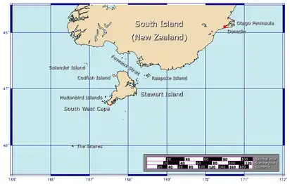 The position of The Snares relative to New Zealand | |
| Geography | |
|---|---|
| Coordinates | 48°02′35″S 166°37′15″E / 48.04306°S 166.62083°E |
| Archipelago | The Snares |
| Length | 1 km (0.6 mi) |
| Width | 0.5 km (0.31 mi) |
| Highest elevation | 86 m (282 ft) |
| Administration | |
| Demographics | |
| Population | 0 |
Broughton Island is the second largest island of The Snares,[1] at 48°02′35″S 166°37′15″E / 48.04306°S 166.62083°E. It sits just off the South Promontory of the main island, North East Island, which itself lies approximately 200 kilometres (120 mi) south of New Zealand's South Island.
The island is some 1 by 0.5 km (0.62 by 0.31 mi) in size, with the main axis running northeast to southwest, and the highest elevation is 86 m (282 ft). The island is named after William Robert Broughton.[1]
See also
References
- 1 2 (DOC), corporatename = New Zealand Department of Conservation. "Snares Islands: New Zealand's subantarctic islands". www.doc.govt.nz. Retrieved 2 December 2015.
This article is issued from Wikipedia. The text is licensed under Creative Commons - Attribution - Sharealike. Additional terms may apply for the media files.