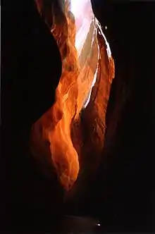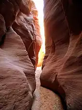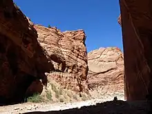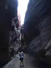


Buckskin Gulch (also known as Buckskin Creek, Buckskin Wash, and Kaibab Gulch) is a gulch and canyon located in southern Kane County, Utah, near the Arizona border.[1] With a length of over 13 mi (21 km), it is one of the main tributaries of the Paria River, a tributary of the Colorado River.
Buckskin Gulch is one of the longest and deepest slot canyons in the Southwestern United States.[2][3][4][5]
Wire Pass,[6] a short tributary to Buckskin (and the most common means by which Buckskin Gulch is accessed), have features of narrow, curving features of the slot canyons.[7]
Access
Buckskin Gulch is reached via U. S. Route 89 (US‑89) in Utah, roughly halfway between the towns of Kanab, Utah, and Page, Arizona. There are five access routes to the canyon, including Buckskin Trailhead, Wire Pass Trailhead, White House trailhead, and Lee's ferry trailhead.[8]
Regulations
Permits are required for overnight backpacking as well as day hiking in Buckskin Gulch and the Paria Canyon-Vermilion Cliffs Wilderness. Permits can be obtained from the Bureau of Land Management (BLM) official website.
Only twenty overnight permits per day are allowed, and group sizes are limited to ten people. Campfires are prohibited, and human waste cannot be buried and must be packed out in order to preserve the condition of the environment.[9][10]
See also
References
- ↑ U.S. Geological Survey Geographic Names Information System: Buckskin Gulch
- ↑ "Shimmy Through the World's Most Spectacular Slot Canyons". www. smithsonianmag.com. Smithsonian Magazine. Retrieved 10 March 2017.
- ↑ "Buckskin Gulch". utah.com. Retrieved 5 June 2020.
- ↑ "Buckskin Gulch". /www. zionnational-park.com. Retrieved 5 June 2020.
- ↑ "Buckskin Gulch". americansouthwest.net. The American Southwest. Retrieved 18 January 2007.
- ↑ U.S. Geological Survey Geographic Names Information System: Wire Pass
- ↑ "Buckskin Gulch". americansouthwest.net. The American Southwest. Retrieved 18 January 2007.
- ↑ "Buckskin Gulch Trail Guide: Backpacking the Paria River and Buckskin Gulch". wildbackpacker.com. Wild Backpacker. Retrieved June 5, 2020.
- ↑ "Paria Canyon Permit Area: Vermilion Cliffs National Monument / Paria Canyon / Vermilion Cliffs Wilderness". blm.gov. Bureau of Land Management. Retrieved June 5, 2020.
- ↑ "Paria Canyon-Vermilion Cliffs Wilderness permit information". blm.gov. July 10, 2006. Archived from the original on March 9, 2007. Retrieved June 5, 2020 – via Wayback Machine.
External links
- Paria Canyon-Vermillion Cliffs Wilderness
- Buckskin Gulch at climb-Utah.com, a detailed description of the hike from Wire Pass, with GPS waypoints
- Buckskin Gulch GPS map Buckskin Gulch at Wikiloc.com. See the trail on Google Maps and Google Earth.
- Grand Gulch at Bureau of Land Management