Bukit Beruang | |
|---|---|
| Kampong Bukit Beruang | |
 Bukit Beruang National Housing Scheme | |
 Location in Brunei | |
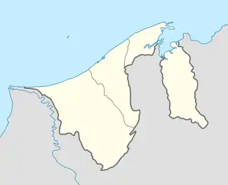
| Coordinates: 4°43′42″N 114°36′40″E / 4.7284°N 114.6111°E | |
| Country | Brunei |
| District | Tutong |
| Mukim | Telisai |
| Government | |
| • Village head | Azman Ismail[1] |
| Population (2016)[2] | |
| • Total | 6,157 |
| Time zone | UTC+8 (BNT) |
| Postcode | TC3145, TC3345 |
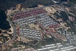
Kampong Bukit Beruang (Malay: Kampung Bukit Beruang), also simply known as Bukit Beruang, is a village in Tutong District, Brunei, about 13 kilometres (8.1 mi) from the district town Pekan Tutong. The population was 6,157 in 2016.[2] It is one of the villages within Mukim Telisai, a mukim subdivision in the district.[3] It comprises the original village settlement as well as the public housing estate Bukit Beruang National Housing Scheme.
Name
The name Bukit Beruang, which meaning Hill of Bears, is one of the more well-known place names. According to one myth, bears used to inhabit the area, which is how the place got its name. Sungai Beruang (Bears' Stream) is the name of a creek in Tutong, which may be related to the same bears.[4]
The village was originally named Tepangan Beruang, which means 'A tree where a bear nests'. Bears are believed to nest on trees and that tree is called tepangan. At that time, the village had many bears to the point where its commonly seen in the forest, especially by some people from Kampong Penyatang and Kampong Danau who use boats through Penyatang River and Uropyang River. These rivers are used as a route for them to go back and forth doing farming activities and visiting (buying and selling).[5]
History
Kampong Bukit Beruang was the meeting between the people on the land side, namely Kampong Bukit Udal and its surroundings and from the villages on the north side such as Kampong Penyatang, Kampong Danau and Kampong Telisai. By using the river journey while trading and visiting a place called Tamuan Lawai, the people on the sea side bring goods such as dried fish, belacan and so on while the people on the land side bring their crops such as rice, cassava, sugarcane and so on . The history began to be recorded around the 1940s and 1950s.[5]
Public housing
The public housing estate has an area of 49 hectares (120 acres) and as of 2018 consist of 530 detached houses, 1,368 units of terraces, and 368 'cluster' houses of 4-units each.[6] It is one of the only two public housing estates in the district; the other one is STKRJ Kampong Telisai.[7]
The housing estate began construction in 2010 and was contracted to Tee international from Singapore. It was planned to complete 1,500 houses by 2013.[8]
Infrastructure

Facilities located in the village include:
- Dewan Kemasyarakatan Bukit Beruang, the village community hall
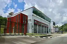
- Bukit Beruang Fire Station, opened in 2014 and one of the only three fire stations in the district.[9]
Education
The local primary schools include:
- Pengiran Kesuma Negara Bukit Beruang Primary School — It was formerly known as Sekolah Melayu Bukit Beruang ("Bukit Beruang Malay School").[10] The current building began to be used in 1999.[10] As of 2004, it had 33 teachers for the morning session and 11 in the afternoon, as well as 364 pupils from preschool to Primary 6.[10] The school facilities include classrooms, library, dental clinic, playground and canteen.[10]
- Perpindahan Kampong Bukit Beruang II Primary School
- Tutong Sixth Form Centre, the only sixth form college in the district
- Sayyidina 'Othman Secondary School, the government secondary school for the residents of Mukim Telisai
Each school also shares grounds with a sekolah ugama i.e. school for the country's Islamic religious primary education.
Religion
Rancangan Perumahan Negara Bukit Beruang Mosque is the village mosque.
References
- ↑ "Undi, Pilih Calon Penghulu, Ketua Kampung | Brunei's No.1 News Website". brudirect.com. Retrieved 25 April 2023.
- 1 2 "Population and Housing Census Update Final Report 2016" (PDF). www.deps.gov.bn. Department of Statistics. December 2018. Retrieved 12 July 2021.
- ↑ "Tutong District" (PDF). www.information.gov.bn. p. 9. Retrieved 18 April 2018.
- ↑ Mohd Yunos, Rozan (2013). SEMINAR UNITED NATIONS GROUP OF EXPERTS ON GEOGRAPHICAL NAMES ASIA, SOUTHEAST DIVISION (PDF). p. 18.
- 1 2 KOMPILASI RENCANA KNK 2015 (PDF) (in Malay). Kenali Negera Kitani. 2015. pp. 111–114.
- ↑ "HM presents keys to 601 new homeowners, tours Tutong - The Scoop". The Scoop. 21 February 2018. Retrieved 18 April 2018.
- ↑ "Tutong District" (PDF). www.information.gov.bn. p. 22. Retrieved 18 April 2018.
- ↑ Business Opportunities in Brunei Darussalam - Infrastructure Implementation. Ministry of Foreign Affairs. p. 28.
- ↑ "Laman Utama - Carta Organisasi". fire-rescue.gov.bn. Retrieved 29 September 2017.
- 1 2 3 4 Abd. Karim HAB (30 August 2004). "64 orang menerima geran dan lot tanah" (PDF). Pelita Brunei (in Malay). No. 49 #35 (published 1 September 2004). Jabatan Penerangan. pp. 1, 16. Retrieved 21 November 2021.