| Carwoola Parish New South Wales | |||||||||||||||
|---|---|---|---|---|---|---|---|---|---|---|---|---|---|---|---|
| LGA(s) | Queanbeyan-Palerang Regional Council | ||||||||||||||
| County | Murray | ||||||||||||||
| |||||||||||||||

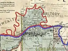
Highlighted on the map:
Part of the current parish boundary
Area between the Molonglo River and the Goulburn-Queanbeyan railway transferred to the Commonwealth for the ACT in 1909
Carwoola Parish is a parish of Murray County, a cadastral unit for use on land titles. It is located to the south of the Australian Capital Territory and to the south-east of Queanbeyan. The original northern and eastern boundary was the Molonglo River; this is still the boundary for most of the parish, except in the north, where the relatively small area north of the Queanbeyan-Goulburn railway line (at 35°19′42″S 149°17′45″E / 35.32833°S 149.29583°E ) was transferred to the ACT in 1909. The south-western boundary is the Queanbeyan River. Captain's Flat Road is the major road running through the parish. The area also roughly aligns with the locality of Carwoola.
References
- Map showing proposed Federal Capital Territory and tenures of land within same, Charles Robt. Scrivener, 22 May 1909
- "Carwoola Parish". Geographical Names Register (GNR) of NSW. Geographical Names Board of New South Wales.
35°23′00″S 149°19′00″E / 35.38333°S 149.31667°E
This article is issued from Wikipedia. The text is licensed under Creative Commons - Attribution - Sharealike. Additional terms may apply for the media files.