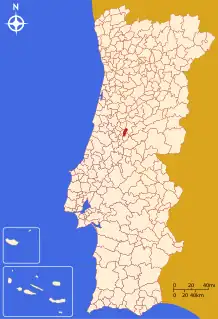
Castanheira de Pera | |
|---|---|
_(cropped).jpg.webp) | |
 Flag  Coat of arms | |
 | |
| Coordinates: 40°00′N 8°13′W / 40.000°N 8.217°W | |
| Country | |
| Region | Centro |
| Intermunic. comm. | Região de Leiria |
| District | Leiria |
| Parishes | 1 |
| Government | |
| • President | Fernando José Pires Lopes (PS) |
| Area | |
| • Total | 66.77 km2 (25.78 sq mi) |
| Population (2011) | |
| • Total | 3,191 |
| • Density | 48/km2 (120/sq mi) |
| Time zone | UTC±00:00 (WET) |
| • Summer (DST) | UTC+01:00 (WEST) |
| Local holiday | July 4 |
| Website | http://www.cm-castanheiradepera.pt |
Castanheira de Pera (Portuguese pronunciation: [kɐʃtɐˈɲɐjɾɐ ðɨ ˈpeɾɐ] ⓘ), often erroneously written Castanheira de Pêra, is a municipality in the district of Leiria in Portugal. The population in 2011 was 3,191,[1] in an area of 66.77 km².[2]
The present Mayor is Fernando José Pires Lopes, elected by the Socialist Party. The municipal holiday is on July 4.
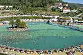 Roca's Beach
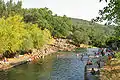 Corga
Corga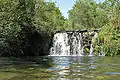 Véras
Véras St. António da Neve
Parishes
Administratively, the municipality consists of 1 civil parish (freguesia):[3]
- Castanheira de Pera e Coentral
Climate
| Climate data for Castanheira de Pera, 1934-1960 normals, 1981-2021 precipitation | |||||||||||||
|---|---|---|---|---|---|---|---|---|---|---|---|---|---|
| Month | Jan | Feb | Mar | Apr | May | Jun | Jul | Aug | Sep | Oct | Nov | Dec | Year |
| Mean daily maximum °C (°F) | 13.7 (56.7) |
15.3 (59.5) |
17.7 (63.9) |
20.7 (69.3) |
22.4 (72.3) |
26.9 (80.4) |
30.2 (86.4) |
30.7 (87.3) |
28.2 (82.8) |
23.2 (73.8) |
17.9 (64.2) |
14.4 (57.9) |
21.8 (71.2) |
| Daily mean °C (°F) | 8.9 (48.0) |
9.9 (49.8) |
12.2 (54.0) |
14.6 (58.3) |
16.2 (61.2) |
19.9 (67.8) |
22.4 (72.3) |
22.7 (72.9) |
20.8 (69.4) |
17.0 (62.6) |
12.6 (54.7) |
9.4 (48.9) |
15.6 (60.0) |
| Mean daily minimum °C (°F) | 4.1 (39.4) |
4.5 (40.1) |
6.8 (44.2) |
8.4 (47.1) |
10.0 (50.0) |
12.9 (55.2) |
14.5 (58.1) |
14.7 (58.5) |
13.4 (56.1) |
10.7 (51.3) |
7.4 (45.3) |
4.4 (39.9) |
9.3 (48.8) |
| Average precipitation mm (inches) | 207.2 (8.16) |
174.8 (6.88) |
103.1 (4.06) |
155.8 (6.13) |
144.5 (5.69) |
52.1 (2.05) |
11.5 (0.45) |
16.3 (0.64) |
60.1 (2.37) |
175.9 (6.93) |
195.9 (7.71) |
231.6 (9.12) |
1,528.8 (60.19) |
| Average relative humidity (%) | 80 | 76 | 72 | 68 | 69 | 60 | 60 | 60 | 65 | 72 | 78 | 80 | 70 |
| Source: Portuguese Environment Agency[4][5] | |||||||||||||
Notable people
- Kalidás Barreto (1932–2020) a Portuguese accountant and trade unionist; active in Castanheira de Pera where he died
- João Carvalho (born 1997) a Portuguese footballer with nearly 200 club caps, he plays for Nottingham Forest F.C.
References
- ↑ Instituto Nacional de Estatística Archived November 15, 2016, at the Wayback Machine
- ↑ "Áreas das freguesias, concelhos, distritos e país". Archived from the original on 2018-11-05. Retrieved 2018-11-05.
- ↑ Diário da República. "Law nr. 11-A/2013, page 552 34" (pdf) (in Portuguese). Retrieved 20 July 2014.
- ↑ "Plano Municipal de Defesa da Floresta Contra Incêndios" (PDF). Castanheira de Pera Municipality. Retrieved 25 June 2021.
- ↑ "SNIRH > Dados de Base". snirh.apambiente.pt. Retrieved 25 June 2021.
External links
This article is issued from Wikipedia. The text is licensed under Creative Commons - Attribution - Sharealike. Additional terms may apply for the media files.