| Chandrabhaga | |
|---|---|
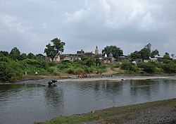 Chandrabhaga river at Chamak Khurd in Amravati district. | |
| Location | |
| Country | India |
| State | Maharashtra |
| Region | Vidarbha |
| District | Amravati |
| City | Daryapur |
| Physical characteristics | |
| Source | |
| • location | Chikhaldara hills, Maharashtra, India |
| • coordinates | 21°23′0″N 77°16′1″E / 21.38333°N 77.26694°E |
| Mouth | |
• location | Purna river |
• coordinates | 20°51′20.75″N 77°15′3.3″E / 20.8557639°N 77.250917°E |
| Basin features | |
| Tributaries | |
| • left | Bhuleshwari |
Chandrabhaga is one of the major rivers in Amravati district of Maharashtra. As a tributary of the Purna, it forms a part of the Tapti-Purna river system.
The main stream of the river rises down the Vairat Plateau in the Chikhaldara hills[1] and takes an eastward course draining the south slopes of Chikhaldara and Gawilgarh plateaus.[2] dam is built on the river as it comes out of the valley. The river takes a more southward turn from the dam and passes through the town of Daryapur before it meets with river Purna on the border of Amravati and Akola district. Bhuleshwari is a chief tributary of Chandrabhaga that meets it before Daryapur. Sapan and Bichan rivers flowing through Achalpur and Paratwada are other affluent streams.[2]
Notes and references
- ↑ Khadri, S. F. R. (2011). "Hydro geological investigations of the Chandrabhaga River basin, Chikaldhara Region, Amravati District, MS, India" (PDF). International Journal of Earth Sciences and Engineering. 4 (6): 262–269. Archived from the original (PDF) on 18 December 2011.
- 1 2 "Rivers - The Gazetteers Department - Amravati". Retrieved 15 December 2012.
This article is issued from Wikipedia. The text is licensed under Creative Commons - Attribution - Sharealike. Additional terms may apply for the media files.