Arrondissement of Charleroi
Arrondissement de Charleroi | |
|---|---|
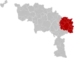 Location of the arrondissement in Hainaut | |
| Coordinates: 50°27′N 4°27′E / 50.45°N 4.45°E | |
| Country | |
| Region | |
| Province | |
| Municipalities | 12 |
| Area | |
| • Total | 472.19 km2 (182.31 sq mi) |
| Population (1 January 2017) | |
| • Total | 430,128 |
| • Density | 910/km2 (2,400/sq mi) |
| Time zone | UTC+1 (CET) |
| • Summer (DST) | UTC+2 (CEST) |
The Arrondissement of Charleroi (French: Arrondissement de Charleroi; Dutch: Arrondissement Charleroi) is one of the seven administrative arrondissements in the Walloon province of Hainaut, Belgium.[1] It is both an administrative and a judicial arrondissement. However, the Judicial Arrondissement of Charleroi also comprises the municipalities of the Arrondissement of Thuin.
Municipalities
The Administrative Arrondissement of Charleroi consists of the following municipalities:
Since 2019
Before 2019
|
|
The municipalities of Manage and Seneffe are transferred on January 1, 2019 to the Arrondissement of Soignies.
References
- ↑ Lesthaeghe, Ron (January 2010). "Long-term Spatial Continuities in Demographic Innovations: Insights from the Belgian Example, 1846-2000" (PDF). Population Studies Center Research Report.
| Judicial area of Antwerp | |
|---|---|
| Judicial area of Brussels | |
| Judicial area of Ghent | |
| Judicial area of Liège | |
| Judicial area of Mons | |
This article is issued from Wikipedia. The text is licensed under Creative Commons - Attribution - Sharealike. Additional terms may apply for the media files.