| Kunar Mastuj, Chitral, Kama | |
|---|---|
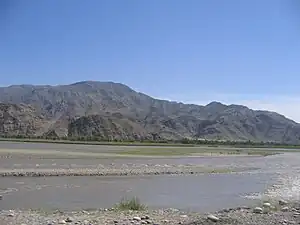 | |
.png.webp) Course of the Kunar | |
| Location | |
| Countries | Afghanistan and Pakistan |
| Provinces | Khyber Pakhtunkhwa (Pakistan) (Afghanistan) |
| Physical characteristics | |
| Source | Hindu Kush Mountains |
| Mouth | Kabul River |
• location | Jalalabad |
| Length | 480 km (300 mi) |
| Basin size | 26,000 km2 (10,000 sq mi) |
| Basin features | |
| Tributaries | |
| • left | Shishi River |
| • right | Lotkoh River, Landai Sin River, Pech River |
The Kūnaṛ River (Urdu: دریائے کونڑ; Pashto: د کونړ سيند; Khowar: کونڑ سيند), also known as the Chitral River (Urdu: دریائے چترال), Mastuj River (Pashto: مستوج سيند) and Kama River (Khowar: کامې سيند), is a 480 kilometres (300 mi) long river located in northern Pakistan and eastern Afghanistan. It originates just south of the Hindu Kush Mountains, in the north of Afghanistan's Badakhshan province. It later merges with Kabul river in the Nangahar Province of Afghanistan. The river system is fed by melting glaciers and snow of the Hindu Kush mountains. The Kunar is a tributary of the Kabul river, which is in turn a tributary of the Indus River.[1]
Origin and course of flow
The river originates from the northern mountain ranges of Hindukush, in the district of Chitral, Pakistan. It is named here as Chitral/Mastuj river.[2] Around 60% to 70% of annual discharge of Kunar river originates from Hindu Kush Region.[3] Downstream as far as the town of Mastuj, it is called as the Mastuj river, till its confluence with the Lotkoh river.[4] Kunar then turns southwards into the upper Kunar Valley of Afghanistan. At the confluence in Asadabad, it meets with Pech River and finally empties into the Kabul River just to the east of the city of Jalalabad in Afghanistan.[2] The combined rivers then flow eastwards into Pakistan again, and joins the Indus River at the city of Attock.[2]

See also
References
- ↑ The Afghan War, 1838-1842: From the Journal and Correspondence of the Late Major-General Augustus Abbott, editor Charles Rathbone Low, publisher R. Bentley & Son, 1879, Google Books
- 1 2 3 Ahmad, Mahmood (2023-09-26). Water Policy in Pakistan: Issues and Options. Springer Nature. p. 327. ISBN 978-3-031-36131-9.
- ↑ Watto, Muhammad Arif; Mitchell, Michael; Bashir, Safdar (2021-03-25). Water Resources of Pakistan: Issues and Impacts. Springer Nature. p. 45. ISBN 978-3-030-65679-9.
- ↑ Pakistan & the Karakoram. Lonely Planet. 2008. p. 233. ISBN 9781741045420.
Further reading
- Allan, Nigel J. R.; Buddruss, Georg (1991). "CHITRAL". Encyclopaedia Iranica, Vol. V, Fasc. 5. pp. 487–494.