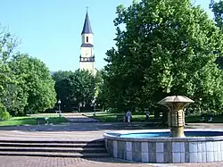
Chlumec | |
|---|---|
 Town square | |
 Flag  Coat of arms | |
 Chlumec Location in the Czech Republic | |
| Coordinates: 50°41′50″N 13°56′20″E / 50.69722°N 13.93889°E | |
| Country | |
| Region | Ústí nad Labem |
| District | Ústí nad Labem |
| First mentioned | 993 |
| Government | |
| • Mayor | Veronika Srnková |
| Area | |
| • Total | 12.87 km2 (4.97 sq mi) |
| Elevation | 235 m (771 ft) |
| Population (2023-01-01)[1] | |
| • Total | 4,253 |
| • Density | 330/km2 (860/sq mi) |
| Time zone | UTC+1 (CET) |
| • Summer (DST) | UTC+2 (CEST) |
| Postal codes | 400 10, 403 39 |
| Website | www |
Chlumec (German: Kulm) is a town in Ústí nad Labem District in the Ústí nad Labem Region of the Czech Republic. It has about 4,300 inhabitants.
Administrative parts
Villages of Český Újezd, Hrbovice, Stradov, Střížovice and Žandov are administrative parts of Trmice. Český Újezd, Hrbovice and Střížovice form an exclave of the municipal territory.
Geography
Chlumec is located about 5 kilometres (3 mi) northwest of Ústí nad Labem. There are two significant ponds in the territory, Nový and Zámecký.
The towns extends into three geomorphological regions. Most of the municipal territory lies in the eastern tip of the Most Basin lowlands, the northern part lies in the Ore Mountains, and the villages of Český Újezd and Střížovice lie on the slopes of the Central Bohemian Uplands.
History
The first written mention of Chlumec is in a deed of Duke Boleslaus II from 993, where the obligation of Chlumec to pay tithe to the newly established Břevnov Monastery is mentioned. In 1521, Chlumec became a town.[2]
The Battle of Chlumec was fought on 18 February 1126 in the vicinity of the village, the culmination of a 12th-century war of succession in the Duchy of Bohemia.[2]
After the great Battle of Dresden (26–27 August 1813), the Battle of Kulm took place here on 29–30 August, between the French Empire under Dominique Vandamme and an allied army of Austrians, Prussians, and Russians. The French were defeated and Vandamme surrendered with his army of 10,000 men. The heights above Chlumec were the site of the Second Battle of Kulm, 17 September 1813.[2]
Demographics
|
|
| ||||||||||||||||||||||||||||||||||||||||||||||||||||||
| Source: Censuses[3][4] | ||||||||||||||||||||||||||||||||||||||||||||||||||||||||
Transport
The D8 motorway (part of the European route E55) from Ústí nad Labem to the Czech-German border runs next to the town.
Sights
_-_kaple_Nejsv%C4%9Bt%C4%9Bj%C5%A1%C3%AD_Trojice_na_vrchu_Horka_(4).jpg.webp)
The most valuable monument is the Chapel of the Holy Trinity, located on the Horka hill. It was built in the Baroque style in 1690–1691. In 1838, the family tomb of the Westhalen-Fürstenberg noble family was built under the chapel. The Way of the Cross leads to the chapel. It was founded in 1751–1752 by Countess Marie Alžběta Krakovská of Kolowrat.[5]
The main landmark of the centre of the town is the Church of Saint Gall. It was built in 1847–1852.[6]
Notable people
- Johann Georg Urbansky (1675–1738), Bohemian-German sculptor
References
- ↑ "Population of Municipalities – 1 January 2023". Czech Statistical Office. 2023-05-23.
- 1 2 3 "Historie, kroniky" (in Czech). Město Chlumec. Retrieved 2021-07-10.
- ↑ "Historický lexikon obcí České republiky 1869–2011 – Okres Ústí nad Labem" (in Czech). Czech Statistical Office. 2015-12-21. pp. 1–2.
- ↑ "Population Census 2021: Population by sex". Public Database. Czech Statistical Office. 2021-03-27.
- ↑ "Kaple Nejsvětější Trojice" (in Czech). National Heritage Institute. Retrieved 2023-06-12.
- ↑ "Vyhodnocení vlivů územního plánu na životní prostředí: Návrh územního plánu Chlumce" (PDF) (in Czech). Czech Environmental Information Agency. 2013. p. 54. Retrieved 2023-06-12.