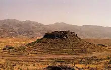
Tighremt, Agadir, Region Souss-Massa-Draa
Chtouka Aït Baha is a province in the Moroccan economic region of Souss-Massa. Its population in 2004 was 297,245.
Subdivisions
The province is divided administratively into the following:[1]
| Name | Geographic code | Type | Households | Population (2004) | Foreign population | Moroccan population | Notes |
|---|---|---|---|---|---|---|---|
| Ait Baha | 163.01.03. | Municipality | 1062 | 4767 | 1 | 4766 | |
| Biougra | 163.01.11. | Municipality | 6061 | 25928 | 15 | 25913 | |
| Ait Mzal | 163.03.05. | Rural commune | 917 | 4555 | 0 | 4555 | |
| Ait Wadrim | 163.03.07. | Rural commune | 1438 | 7366 | 0 | 7366 | |
| Aouguenz | 163.03.09. | Rural commune | 1304 | 5886 | 0 | 5886 | |
| Hilala | 163.03.13. | Rural commune | 734 | 3831 | 0 | 3831 | |
| Ida Ougnidif | 163.03.15. | Rural commune | 864 | 3151 | 0 | 3151 | |
| Sidi Abdallah El Boushwari | 163.03.25. | Rural commune | 1713 | 9068 | 1 | 9067 | |
| Tanalt | 163.03.33. | Rural commune | 920 | 3536 | 0 | 3536 | |
| Targua Ntoushkka | 163.03.35. | Rural commune | 1244 | 6552 | 0 | 6552 | |
| Tassegdelt | 163.03.37. | Rural commune | 1168 | 6526 | 0 | 6526 | |
| Tizi Ntakousht | 163.03.39. | Rural commune | 484 | 1951 | 0 | 1951 | |
| Ait Milk | 163.05.03. | Rural commune | 2112 | 11414 | 0 | 11414 | |
| Belfaa | 163.05.11. | Rural commune | 4370 | 22406 | 2 | 22404 | |
| Inshaden | 163.05.19. | Rural commune | 4484 | 21542 | 4 | 21538 | |
| Massa | 163.05.21. | Rural commune | 3339 | 16526 | 5 | 16521 | 8999 residents live in the center, called Massa; 7527 residents live in rural areas. |
| Sidi wassay | 163.05.31. | Rural commune | 1682 | 8571 | 25 | 8546 | |
| Ait Amira | 163.07.01. | Rural commune | 10674 | 47458 | 7 | 47451 | |
| Imi Mqourn | 163.07.17. | Rural commune | 2063 | 11748 | 0 | 11748 | |
| wad Essafa | 163.07.23. | Rural commune | 7796 | 39386 | 7 | 39379 | |
| Sidi Bibi | 163.07.27. | Rural commune | 5108 | 24639 | 8 | 24631 | |
| Sidi Boushab | 163.07.29. | Rural commune | 1882 | 10438 | 0 | 10438 | |
References
- ↑ "Recensement général de la population et de l'habitat de 2004" (PDF). Haut-commissariat au Plan, Lavieeco.com. Archived from the original (PDF) on 24 July 2012. Retrieved 27 April 2012.
30°02′N 9°04′W / 30.033°N 9.067°W
This article is issued from Wikipedia. The text is licensed under Creative Commons - Attribution - Sharealike. Additional terms may apply for the media files.