Cittanova | |
|---|---|
| Comune di Cittanova | |
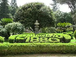 Villa "Carlo Ruggiero" (entrance). | |
 Coat of arms | |
.svg.png.webp) Cittanova within the Province of Reggio Calabria | |
Location of Cittanova | |
 Cittanova Location of Cittanova in Italy 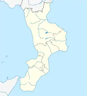 Cittanova Cittanova (Calabria) | |
| Coordinates: 38°21′N 16°5′E / 38.350°N 16.083°E | |
| Country | Italy |
| Region | Calabria |
| Metropolitan city | Reggio Calabria (RC) |
| Government | |
| • Mayor | Francesco Cosentino |
| Area | |
| • Total | 61.8 km2 (23.9 sq mi) |
| Elevation | 400 m (1,300 ft) |
| Population (November 2020)[2] | |
| • Total | 9,977 |
| • Density | 160/km2 (420/sq mi) |
| Demonym | Cittanovesi |
| Time zone | UTC+1 (CET) |
| • Summer (DST) | UTC+2 (CEST) |
| Postal code | 89022 |
| Dialing code | 0966 |
| Patron saint | St. Jerome |
| Saint day | September 30 |
| Website | Official website |
Cittanova is a comune (municipality) in the Metropolitan City of Reggio Calabria in the Italian region Calabria, located about 80 kilometres (50 mi) southwest of Catanzaro and about 45 kilometres (28 mi) northeast of Reggio Calabria.
Located on the slopes of Aspromonte and facing the Gioia Tauro plain, it is characterized by the presence of numerous churches and a public park which extends for 2.65 hectares (6.55 ac).
Geography
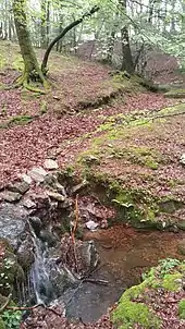
The town is located at the foot of the Aspromonte, on alluvial quaternary soils, consisting of incoherent sands and gravels that cover the large terraces sloping down towards the Gulf of Gioia. Cittanova dominates the Gioia Tauro plain from the highest terrace, the one bordering the massif of the Serre Calabresi, almost in contact between the two lithological formations: alluvial and crystalline.
This geological conformation favors the propagation of earthquakes, as the incoherence of the alluvial cover is increased during earthquakes by the contiguous and underlying crystalline formation. The territory of Cittanova is crossed by the homonymous fault which is part of the Serre-Aspromonte fault system, 30 kilometers long and still active.[3]
The altitude referring to the town hall building is 400 meters above mean sea level, in the municipal area the minimum altitude reaches 77 m above mean sea level while the maximum reaches 996 meters.[4] The surface is 61.98 km² [5] (about 65% in flat land planted with olive trees and 35% in mountainous wooded land and natural pastures).
The main water courses are the torrents Serra and Vacale.
Main peaks: Melìa plateau (m. 1,000), Zomaro (m. 920) and Mount Cuculo (m. 725).
Zomaro is located on the Melìa plateau, inside the Aspromonte National Park. The flora that characterizes it is mainly composed of beeches, holm oaks, firs and brooms. Also present is Woodwardia radicans, an ancient giant fern which survived the Cenozoic. The fauna has numerous wild boars as well as squirrels, badgers, foxes, owls and black kites. The plateau is also rich in spring waters.
Cittanova borders the following municipalities: Antonimina, Canolo, Ciminà, Gerace, Melicucco, Molochio, Polistena, Rizziconi, Rosarno, San Giorgio Morgeto and Taurianova.
Climate
The climate is Mediterranean. The plain of Gioia, open to the sea but sheltered from the winds, increases the humidity, making the land particularly fertile.
| Climate data for Cittanova | |||||||||||||
|---|---|---|---|---|---|---|---|---|---|---|---|---|---|
| Month | Jan | Feb | Mar | Apr | May | Jun | Jul | Aug | Sep | Oct | Nov | Dec | Year |
| Daily mean °C (°F) | 9 (48) |
10 (50) |
11 (52) |
13 (55) |
16 (61) |
21 (70) |
24 (75) |
23 (73) |
22 (72) |
17 (63) |
12 (54) |
9 (48) |
15.6 (60.1) |
| Average precipitation mm (inches) | 233 (9.2) |
164 (6.5) |
155 (6.1) |
100 (3.9) |
92 (3.6) |
44 (1.7) |
21 (0.8) |
27 (1.1) |
83 (3.3) |
159 (6.3) |
234 (9.2) |
221 (8.7) |
1,533 (60.4) |
| Source: Ambiente fisico e dissesto idrogeologico del versante tirrenico reggino | |||||||||||||
History
Cittanova (Italian for "New City") was born in 1618, in the wake of the disastrous earthquake of 1616, as the Nuovo Casale di Curtuladi ("New Hamlet of Curtuladi"), then Casalnuovo upgraded to city status as Cittanova.
The city was all but demolished in the great earthquake of 1783 that damaged Messina.[6]
Demographics
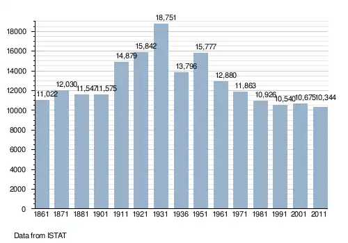
Twin towns
References
- ↑ "Superficie di Comuni Province e Regioni italiane al 9 ottobre 2011". Italian National Institute of Statistics. Retrieved 16 March 2019.
- ↑ All demographics and other statistics: Italian statistical institute Istat.
- ↑ Galli, Paolo; Peronace, Edoardo; Messina, Paolo. "I terremoti olocenici della faglia di Cittanova (Calabria meridionale): nuovi dati paleosismologici". Atti del 33º Convegno Nazionale GNGTS, Bologna 25-27 Novembre 2014: 72–79. ISBN 978-88-940442-1-8. Archived from the original on March 10, 2017. Retrieved March 10, 2017.
- ↑ "Tuttitalia.it - Comune di Cittanova (RC)". tuttitalia.it. Retrieved 2013-06-25.
- ↑ "ISTAT.IT La superficie dei comuni, delle province e delle regioni italiane". Retrieved 2014-10-16.
- ↑ On-line history of Cittanova
External links
![]() Media related to Cittanova at Wikimedia Commons
Media related to Cittanova at Wikimedia Commons
