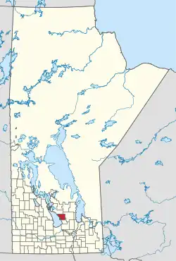
Coldwell | |
|---|---|
| Rural Municipality of Coldwell | |
 Location of Coldwell in Manitoba | |
| Coordinates: 50°38′20″N 98°02′30″W / 50.63889°N 98.04167°W | |
| Country | Canada |
| Province | Manitoba |
| Incorporated | November 19, 1912 |
| Area | |
| • Total | 891.85 km2 (344.35 sq mi) |
| Population | |
| • Total | 1,313 |
| • Density | 1.5/km2 (3.8/sq mi) |
| Time zone | UTC-6 (CST) |
| • Summer (DST) | UTC-5 (CDT) |
The Rural Municipality of Coldwell is a rural municipality in the Interlake Region of the province of Manitoba in Western Canada. The principal community within the boundaries is Lundar.
History
The rural municipality was named for George Robson Coldwell, a member of the provincial legislature from 1907 to 1915.[2][3] It was incorporated on November 19, 1912.[3]
Communities
- Clarkleigh
- Lundar
- Lundyville
- Otto
- Vestfold
Government
The Rural Municipality has a municipal style government with four councillors and one head of council, known as the mayor, as well as a deputy mayor. The four councillors represent the municipality at large.[4] Within the borders of the municipality is the Local Urban District of Lundar, which itself has three councillors.[5]
Members
The council of the Rural Municipality of Coldwell is composed of:
- Mayor: Brian Sigfusson
- Councillor/Deputy Mayor: Virgil Johnson
- Councillor: Greg Brown
- Councillor: Jim Scharf
- Councillor: Kent Kostyshyn
Climate
| Climate data for Lundar | |||||||||||||
|---|---|---|---|---|---|---|---|---|---|---|---|---|---|
| Month | Jan | Feb | Mar | Apr | May | Jun | Jul | Aug | Sep | Oct | Nov | Dec | Year |
| Record high °C (°F) | 7 (45) |
7 (45) |
14 (57) |
28 (82) |
34 (93) |
37 (99) |
34 (93) |
38.5 (101.3) |
38 (100) |
29 (84) |
15.5 (59.9) |
9 (48) |
38.5 (101.3) |
| Mean daily maximum °C (°F) | −12.7 (9.1) |
−8 (18) |
−1.3 (29.7) |
9.4 (48.9) |
17.7 (63.9) |
22.8 (73.0) |
24.7 (76.5) |
24.7 (76.5) |
17.7 (63.9) |
9.7 (49.5) |
−2.1 (28.2) |
−9.8 (14.4) |
7.7 (45.9) |
| Daily mean °C (°F) | −18.1 (−0.6) |
−13.5 (7.7) |
−6.6 (20.1) |
3.3 (37.9) |
10.9 (51.6) |
16.4 (61.5) |
18.3 (64.9) |
17.7 (63.9) |
11.3 (52.3) |
4.4 (39.9) |
−6.5 (20.3) |
−14.6 (5.7) |
1.9 (35.4) |
| Mean daily minimum °C (°F) | −23.6 (−10.5) |
−18.8 (−1.8) |
−11.9 (10.6) |
−2.9 (26.8) |
4.1 (39.4) |
9.9 (49.8) |
11.9 (53.4) |
10.6 (51.1) |
4.9 (40.8) |
−1.1 (30.0) |
−10.8 (12.6) |
−19.4 (−2.9) |
−3.9 (25.0) |
| Record low °C (°F) | −44 (−47) |
−45.5 (−49.9) |
−39.5 (−39.1) |
−28 (−18) |
−12 (10) |
−2.5 (27.5) |
0.5 (32.9) |
−2.5 (27.5) |
−7 (19) |
−22 (−8) |
−38 (−36) |
−43.5 (−46.3) |
−45.5 (−49.9) |
| Average precipitation mm (inches) | 14.7 (0.58) |
14.5 (0.57) |
19.8 (0.78) |
27.8 (1.09) |
54.2 (2.13) |
82.5 (3.25) |
66.6 (2.62) |
68.6 (2.70) |
50.6 (1.99) |
35.7 (1.41) |
19.7 (0.78) |
18.5 (0.73) |
473.1 (18.63) |
| Source: Environment Canada[6] | |||||||||||||
Demographics
In the 2021 Census of Population conducted by Statistics Canada, Coldwell had a population of 1,313 living in 552 of its 734 total private dwellings, a change of 4.7% from its 2016 population of 1,254. With a land area of 891.85 km2 (344.35 sq mi), it had a population density of 1.5/km2 (3.8/sq mi) in 2021.[1]
|
| ||||||||||||||||||||||||||||||||||||||||||||||||||||||||||||||||||
References
- 1 2 "Population and dwelling counts: Canada, provinces and territories, and census subdivisions (municipalities), Manitoba". Statistics Canada. February 9, 2022. Retrieved February 20, 2022.
- ↑ Geographical Names of Manitoba. Winnipeg: Manitoba Conservation. 2000. ISBN 0-7711-1517-2. OCLC 51764498.
- 1 2 3 Goldsborough, Gordon (February 11, 2022). "Manitoba Communities: Coldwell (Rural Municipality)". Manitoba Historical Society. Retrieved March 27, 2022.
- ↑ "Government - Council". Community of Lundar & RM of Coldwell. Retrieved March 27, 2022.
- ↑ "Government - LUD - Local Urban District". Community of Lundar & RM of Coldwell. Retrieved March 27, 2022.
- ↑ Environment Canada - Canadian Climate Normals 1971-2000—Canadian Climate Normals 1971–2000, accessed 23 April 2011
