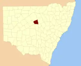
Canbelego
New South Wales
Location in New South Wales
Lands administrative divisions around Canbelego:
Yanda Cowper Clyde
Robinson Canbelego Gregory
Mouramba Flinders Oxley

Canbelego County is one of the 141 Cadastral divisions of New South Wales.

Canbelego is believed to be derived from a local Aboriginal word.[1]

Parishes within this county

A full list of parishes found within this county; their current LGA and mapping coordinates to the approximate centre of each location is as follows:

ParishLGACoordinates
AntaresBogan Shire31°05′54″S 146°54′04″E / 31.09833°S 146.90111°E / -31.09833; 146.90111 (Antares)
BannanBogan Shire31°05′54″S 146°43′59″E / 31.09833°S 146.73306°E / -31.09833; 146.73306 (Bannan)
BerryBogan Shire31°06′37″S 146°40′10″E / 31.11028°S 146.66944°E / -31.11028; 146.66944 (Berry)
BoreeBogan Shire31°27′54″S 147°04′04″E / 31.46500°S 147.06778°E / -31.46500; 147.06778 (Boree)
CarnbillyBogan Shire31°23′54″S 146°46′04″E / 31.39833°S 146.76778°E / -31.39833; 146.76778 (Carnbilly)
CaroBogan Shire31°23′54″S 146°54′04″E / 31.39833°S 146.90111°E / -31.39833; 146.90111 (Caro)
CoreenBogan Shire31°27′54″S 147°02′04″E / 31.46500°S 147.03444°E / -31.46500; 147.03444 (Coreen)
CoureboneBogan Shire31°13′54″S 147°00′04″E / 31.23167°S 147.00111°E / -31.23167; 147.00111 (Courebone)
CurrawongBogan Shire31°27′54″S 146°46′04″E / 31.46500°S 146.76778°E / -31.46500; 146.76778 (Currawong)
EtonCobar Shire31°15′26″S 146°25′13″E / 31.25722°S 146.42028°E / -31.25722; 146.42028 (Eton)
FloridaCobar Shire31°27′03″S 146°18′18″E / 31.45083°S 146.30500°E / -31.45083; 146.30500 (Florida)
GidalamboneBogan Shire31°11′54″S 146°48′04″E / 31.19833°S 146.80111°E / -31.19833; 146.80111 (Gidalambone)
GilgiesBogan Shire31°30′49″S 146°25′03″E / 31.51361°S 146.41750°E / -31.51361; 146.41750 (Gilgies)
GilgoenbonBogan Shire31°25′54″S 147°02′04″E / 31.43167°S 147.03444°E / -31.43167; 147.03444 (Gilgoenbon)
GlenariffBogan Shire31°00′05″S 146°45′45″E / 31.00139°S 146.76250°E / -31.00139; 146.76250 (Glenariff)
GoyderCobar Shire31°21′45″S 146°21′06″E / 31.36250°S 146.35167°E / -31.36250; 146.35167 (Goyder)
GrahweedBogan Shire31°17′54″S 147°02′04″E / 31.29833°S 147.03444°E / -31.29833; 147.03444 (Grahweed)
HallBogan Shire31°05′54″S 147°02′04″E / 31.09833°S 147.03444°E / -31.09833; 147.03444 (Hall)
HermitageBogan Shire31°25′54″S 146°40′04″E / 31.43167°S 146.66778°E / -31.43167; 146.66778 (Hermitage)
KelleyCobar Shire31°19′45″S 146°27′18″E / 31.32917°S 146.45500°E / -31.32917; 146.45500 (Kelley)
KidgeryBogan Shire31°25′54″S 147°02′04″E / 31.43167°S 147.03444°E / -31.43167; 147.03444 (Kidgery)
KingBogan Shire31°23′54″S 146°30′04″E / 31.39833°S 146.50111°E / -31.39833; 146.50111 (King)
LangtreeCobar Shire31°23′41″S 146°24′50″E / 31.39472°S 146.41389°E / -31.39472; 146.41389 (Langtree)
LincolnBogan Shire31°15′54″S 146°44′04″E / 31.26500°S 146.73444°E / -31.26500; 146.73444 (Lincoln)
LynchBogan Shire31°27′54″S 147°08′04″E / 31.46500°S 147.13444°E / -31.46500; 147.13444 (Lynch)
MeesonBogan Shire31°12′05″S 146°33′21″E / 31.20139°S 146.55583°E / -31.20139; 146.55583 (Meeson)
MepungaBogan Shire31°07′57″S 146°29′28″E / 31.13250°S 146.49111°E / -31.13250; 146.49111 (Mepunga)
MerriBogan Shire31°11′59″S 146°40′01″E / 31.19972°S 146.66694°E / -31.19972; 146.66694 (Merri)
MonkellanBogan Shire31°23′54″S 146°34′04″E / 31.39833°S 146.56778°E / -31.39833; 146.56778 (Monkellan)
MulgaCobar Shire31°16′36″S 146°10′30″E / 31.27667°S 146.17500°E / -31.27667; 146.17500 (Mulga)
MurielBogan Shire31°27′54″S 146°34′04″E / 31.46500°S 146.56778°E / -31.46500; 146.56778 (Muriel)
NarramaCobar Shire31°23′50″S 146°16′33″E / 31.39722°S 146.27583°E / -31.39722; 146.27583 (Narrama)
NeileyBogan Shire31°17′54″S 147°00′04″E / 31.29833°S 147.00111°E / -31.29833; 147.00111 (Neiley)
NirrandaBogan Shire31°27′54″S 146°52′04″E / 31.46500°S 146.86778°E / -31.46500; 146.86778 (Nirranda)
NullawarraCobar Shire31°18′55″S 146°16′05″E / 31.31528°S 146.26806°E / -31.31528; 146.26806 (Nullawarra)
OrionBogan Shire31°15′54″S 146°38′04″E / 31.26500°S 146.63444°E / -31.26500; 146.63444 (Orion)
QuandongCobar Shire31°14′10″S 146°16′17″E / 31.23611°S 146.27139°E / -31.23611; 146.27139 (Quandong)
SturtBogan Shire31°01′54″S 146°56′04″E / 31.03167°S 146.93444°E / -31.03167; 146.93444 (Sturt)
The BrothersBogan Shire31°09′54″S 146°44′04″E / 31.16500°S 146.73444°E / -31.16500; 146.73444 (The Brothers)
The PinesBogan Shire31°07′54″S 146°54′04″E / 31.13167°S 146.90111°E / -31.13167; 146.90111 (The Pines)
TootalallyBogan Shire31°05′54″S 146°48′04″E / 31.09833°S 146.80111°E / -31.09833; 146.80111 (Tootalally)
TooramBogan Shire31°10′26″S 146°22′12″E / 31.17389°S 146.37000°E / -31.17389; 146.37000 (Tooram)
TrittonBogan Shire31°19′54″S 146°38′04″E / 31.33167°S 146.63444°E / -31.33167; 146.63444 (Tritton)
VegaBogan Shire31°00′51″S 146°39′39″E / 31.01417°S 146.66083°E / -31.01417; 146.66083 (Vega)
WarongBogan Shire31°27′54″S 146°30′04″E / 31.46500°S 146.50111°E / -31.46500; 146.50111 (Warong)
WarranbillaBogan Shire31°09′54″S 146°58′04″E / 31.16500°S 146.96778°E / -31.16500; 146.96778 (Warranbilla)
WarregoBogan Shire31°17′54″S 146°32′04″E / 31.29833°S 146.53444°E / -31.29833; 146.53444 (Warrego)
WarungoBogan Shire30°59′54″S 146°50′04″E / 30.99833°S 146.83444°E / -30.99833; 146.83444 (Warungo)
WaveneyBogan Shire31°04′21″S 146°34′09″E / 31.07250°S 146.56917°E / -31.07250; 146.56917 (Waveney)
WilgaboneBogan Shire31°17′54″S 146°50′04″E / 31.29833°S 146.83444°E / -31.29833; 146.83444 (Wilgabone)
WilleroonBogan Shire31°01′54″S 147°02′04″E / 31.03167°S 147.03444°E / -31.03167; 147.03444 (Willeroon)
YarranBogan Shire31°06′39″S 146°19′09″E / 31.11083°S 146.31917°E / -31.11083; 146.31917 (Yarran)

References

  1. "Canbelego County". Geographical Names Register (GNR) of NSW. Geographical Names Board of New South Wales.


This article is issued from Wikipedia. The text is licensed under Creative Commons - Attribution - Sharealike. Additional terms may apply for the media files.