 | |
|---|---|
| Route information | |
| Length | 17.0 km (10.6 mi) |
| Major junctions | |
| From | |
| To | Novigrad |
| Location | |
| Country | Croatia |
| Counties | Istria |
| Highway system | |
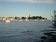
Novigrad, at the western terminus of D301
D301 is a state road connecting A9 with Novigrad and D21 state road. The road is 17.0 km long.[1][2]
The road, as well as all other state roads in Croatia, is managed and maintained by Hrvatske ceste, a state owned company.[3]
Traffic volume
Traffic is regularly counted and reported by Hrvatske ceste, operator of the road.[4] Substantial variations between annual (AADT) and summer (ASDT) traffic volumes are attributed to the fact that the road connects A9 motorway carrying substantial tourist traffic to Novigrad, a major summer resort.
| D301 traffic volume | ||||
| Road | Counting site | AADT | ASDT | Notes |
| 2720 Bužanija south | 5,316 | 9,140 | The only published traffic counting site on D301. | |
Road junctions and populated areas
| D301 junctions/populated areas | |
| Type | Slip roads/Notes |
Eastern terminus of the road. | |
| Nova Vas: L50042 to Brtonigla L50043 to Mirna Valley | |
| Nova Vas interchange: | |
| Ž5070 to Brtonigla | |
| Bužinija | |
| Novigrad: Ž5002 to Antenal and Tar-Vabriga to the south and Dajla and Umag to the north Western terminus of the road. | |
See also
Sources
- ↑ "Decision on categorization of public roads as state roads, county roads and local roads". Narodne novine (in Croatian). February 17, 2010.
- ↑ "Interchanges of the Y". BINA-Istra. May 15, 2010.
- ↑ "Public Roads Act". Narodne novine (in Croatian). December 14, 2004.
- ↑ "Traffic counting on the roadways of Croatia in 2009 - digest" (PDF). Hrvatske ceste. May 1, 2010. Archived from the original (PDF) on July 21, 2011.
This article is issued from Wikipedia. The text is licensed under Creative Commons - Attribution - Sharealike. Additional terms may apply for the media files.