 | |
|---|---|
| Route information | |
| Length | 104.2 km (64.7 mi) |
| Major junctions | |
| From | |
| To | |
| Location | |
| Country | Croatia |
| Counties | Lika-Senj, Zadar |
| Major cities | Otočac, Gospić, Gračac |
| Highway system | |
D50 state road, located mainly in Lika region of Croatia connecting cities and towns of Otočac, Gospić, Perušić and Gračac, to the state road network of Croatia, and most notably to A1 motorway at a number of interchanges - Otočac and Sveti Rok interchanges (directly) and Gospić and Gornja Ploča interchanges (via D534 and D522 state roads respectively).[1] The road is 104.2 km (64.7 mi) long.[2] The route comprises a significant number of urban intersections, in segment of the road running through Gospić.
The D50 state road runs parallel to a section of the A1 motorway between Žuta Lokva and Sveti Rok interchanges, thus serving as an alternate or backup route for the motorway.
The road, as well as all other state roads in Croatia, is managed and maintained by Hrvatske ceste, a state-owned company.[3]
Traffic volume
Traffic is regularly counted and reported by Hrvatske ceste, operator of the road.[4] Substantial variations between annual (AADT) and summer (ASDT) traffic volumes at some counting sites are attributed to the fact that the road connects to D23 and D27 which in turn provide connections to the Adriatic coast resorts and other major highways.
| D50 traffic volume | ||||
| Road | Counting site | AADT | ASDT | Notes |
| 4202 Brlog | 1,368 | 2,823 | Adjacent to Ž5127 junction. | |
| 4203 Otočac (Brlog) | 2,800 | 4,150 | Adjacent to Ž5140 junction. Estimate by HC. | |
| 4205 Ličko Lešće | 1,717 | 1,951 | Adjacent to Ž5147 junction. | |
| 4905 Sveti Rok | 1,412 | 1,481 | Near Sveti Rok. | |
| 4906 Ličko Cerje | 1,135 | 1,640 | The southernmost traffic counting site on the D50 road. | |
Road junctions and populated areas
| D50 major junctions/populated areas | |
| Type | Slip roads/Notes |
The northern terminus of the road. | |
| Ž5127 to Hrvatsko Polje. | |
| Otočac Ž5128 to Glavace and Dabar. Ž5140 to Švica and Krasno Polje. Ž5143 to Prozor. | |
| Čovići Ž5144 to Podhum. | |
| Ž5146 to Studenci and Donji Kosinj. | |
| Ličko Lešće Ž5147 to Vrelo Gacke. | |
| Ž5148 to Ramljani. | |
| Kvarte | |
| Perušić Ž5154 to Klanac. Ž5155 to Kosa Janjačka. | |
| Lički Osik | |
| Ž5171 to Mušaluk. | |
| Budak | |
| Gospić Ž5163 to Lički Novi. | |
| Novoselo Bilajsko Ž5164 to Vrebac and Podlopača. | |
| Medak | |
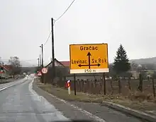
| D547 to Sveti Rok and Obrovac.[5] Ž5165 to Lovinac and Gornja Ploča. | |
| Ričice | |
| Štikada | |
| Gračac D27 may be used as a bypass of both motorway Maslenica bridge and Adriatic Highway Maslenica Bridge for traffic between Zadar and Sveti Rok. The southern terminus of the road. | |
Sources
- ↑ "Regulation on motorway markings, chainage, interchange/exit/rest area numbers and names". Narodne novine (in Croatian). May 6, 2003.
- ↑ "Decision on categorization of public roads as state roads, county roads and local roads". Narodne novine (in Croatian). February 17, 2010.
- ↑ "Public Roads Act". Narodne novine (in Croatian). December 14, 2004.
- ↑ "Traffic counting on the roadways of Croatia in 2009 - digest" (PDF). Hrvatske ceste. May 1, 2010. Archived from the original (PDF) on July 21, 2011.
- ↑ "Decision on categorization of public roads as state roads, county roads and local roads (2020)" (in Croatian). Narodne novine. February 14, 2020. Retrieved April 7, 2020.