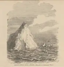
Devils Tower, Bass Strait, Tasmania – 1857 engraving
Devils Tower comprises two small and rugged granite islands, with a combined area of 4.77 hectares (11.8 acres), in south-eastern Australia. It is part of Tasmania’s Curtis Group, lying in northern Bass Strait between the Furneaux Group and Wilsons Promontory in Victoria. It is a nature reserve.
The island was sighted and named by Lieutenant James Grant on 9 December 1800 from the survey brig HMS Lady Nelson.[1]
Fauna
Recorded breeding seabird species include short-tailed shearwater, fairy prion and common diving-petrel. The metallic skink is present. The island is also used as a regular haul-out site for Australian fur seals.[2]
See also
The other islands in the Curtis Group:
References
- ↑ Grant, James (1803). The narrative of a voyage of discovery, performed in His Majesty's vessel the Lady Nelson, of sixty tons burthen: with sliding keels, in the years 1800, 1801, and 1802, to New South Wales. Printed by C. Roworth for T. Egerton. p. 77. ISBN 978-0-7243-0036-5. Retrieved 25 January 2012.
- ↑ Brothers, Nigel; Pemberton, David; Pryor, Helen; & Halley, Vanessa. (2001). Tasmania’s Offshore Islands: seabirds and other natural features. Tasmanian Museum and Art Gallery: Hobart. ISBN 0-7246-4816-X
39°22′S 146°44′E / 39.367°S 146.733°E
This article is issued from Wikipedia. The text is licensed under Creative Commons - Attribution - Sharealike. Additional terms may apply for the media files.