Dimapur | |
|---|---|
City and municipality | |
  .jpg.webp) From Top (Clockwise): City Tower Junction; Aerial view of Dimapur; Ruins of Kachari Rajbari; Dimapur Street | |
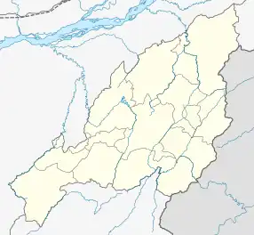 Dimapur Location of Dimapur in Nagaland  Dimapur Dimapur (India)  Dimapur Dimapur (Asia) .svg.png.webp) Dimapur Dimapur (Earth) | |
| Coordinates: 25°55′N 93°44′E / 25.92°N 93.73°E | |
| Country | |
| State | Nagaland |
| District | Dimapur |
| Government | |
| • Type | Municipality |
| • Body | Dimapur Municipal Council |
| • Administrator | Albert Ezüng |
| Area | |
| • City and municipality | 18.13 km2 (7.00 sq mi) |
| • Metro | 70 km2 (30 sq mi) |
| Elevation | 145 m (476 ft) |
| Population | 122,834 |
| • Rank | 1st in Nagaland |
| Languages | |
| • Official | English |
| • Major languages | |
| Time zone | UTC+5:30 (IST) |
| Telephone code | 91 - (0) 03862 |
| Vehicle registration | NL-07 |
| Website | dimapur |
Dimapur (/diməˈpʊər/) is the largest city and municipality in the Indian state of Nagaland. As of 2011, the municipality had a population of 122,834. The city is the main gateway and commercial centre of Nagaland. Located near the border with Assam along the banks of the Dhansiri River. Its main railway station is the second busiest station in Northeast India.The District of Dimapur is bifurcated into two other District namely Chumoukedima and Niuland .
Etymology
The name Dimapur is derived from the Dimasa words; Di means "water", ma means "large" and pur means "city", translating to Big-river-city, associated with the meaning of "Kachari" which is "people of the river valley" and after the river which flows through it (Dhansiri).
There are two accounts of the way in which Dimapur got its name: many writers are of the opinion that the name 'Dimapur' was derived from Dimasa Kachari words Di-meaning water, Ma-meaning big and Pur-meaning city or township in the Dimasa dialect; while others contend that Dimapur is a corruption of Hidimbapur, meaning the city of Hidimbi (of Mahabharata fame) - the rakshasi-turned-woman whose marriage to the Pandava prince Bhima led to the birth of Ghatotkacha, which was the Hindu lineage created for Dimasa rulers by the Brahmin pandits at Khaspur.[4] According to the second theory, the name Hidimbapur is conjectured to have been abbreviated to Dimbapur and subsequently to have lost a consonant to become Dimapur. It is to be noted that Dimasa Kachari Kingdom at point of time was known as the "Heramba Kingdom".[5] In the Ahom Buranjis, Dimapur is referred to sometimes as Che-din-chi-pen (town-earth-burn-make) meaning "Brick-town" and its rulers as khun timisa[6] (distorted word for Dimasa).[7]
History
Situated on the banks of the Dhansiri (originally known as Dong-siri meaning a ravine of peaceful habitation), Dimapur was described as the 'Brick City' by the European scholars and by the Ahoms.
Medieval period
In the 13th century, the city was the capital of the Dimasa Kingdom, which was once a powerful and predominant state in the now North East India (Brahmaputra or Dilao Valley).[8] In the heart of the city there is an old relic of the Dimasa Kachari Kingdom which speaks about the once prosperous era.[9]
The city of Dimapur is said to have been founded by a Kachari king Mahamanipha (1330-1370) and it remained as the capital of the Kacharis until it was captured by the Ahom ruler Suhungmung in 1526 A.D.[10]
The ruins of Dimasa Kingdom in Dimapur include a brick wall of the length of nearly 2 miles and 2 tanks about 300 yards square, are indicative of a city of considerable size.[11]
20th century
World War II
During World War II, Dimapur was the centre of action between British India and Imperial Japan. It was the staging post for the Allied offensive. The Japanese could reach Kohima where a siege was laid. Allied reinforcement came through Dimapur by rail and road for the push against the Japanese. An airport at Dimapur was also in use for supplies to the allied forces in Burma. The battle for Kohima about 77 km from Dimapur is considered the turning point for the Japanese retreat from Southeast Asia.
Assam lease Dimapur to Nagaland
In 1918, Dimapur was leased to then Naga Hills District (Now Nagaland) by then erstwhile Assam Province of British of India for 30 years for construction of Railways lines (unclear from which district).[12] In 1963, it was again leased to now state of Nagaland for 99 years.[13] There is controversy surrounding this claim, as both state governments have not come forward to comment on the matter.[14]
21st century
2004 Dimapur bombings
On 2 October 2004, two powerful bombs were set off—one at the Dimapur Railway Station and the other at the Hong Kong Market killing 30 and injuring over 100 others.[15][16]
Geography
Dimapur is located in the southwest of Nagaland. The vast majority of this area is flat with the Dhansiri River, a tributary of the Brahmaputra River flowing east of the city.
Climate
Dimapur is hot and humid in summers and moderately cold in winters.[17]
| Climate data for Dimapur | |||||||||||||
|---|---|---|---|---|---|---|---|---|---|---|---|---|---|
| Month | Jan | Feb | Mar | Apr | May | Jun | Jul | Aug | Sep | Oct | Nov | Dec | Year |
| Mean daily maximum °C (°F) | 21.3 (70.3) |
24.0 (75.2) |
27.5 (81.5) |
28.5 (83.3) |
29.2 (84.6) |
29.7 (85.5) |
29.5 (85.1) |
29.4 (84.9) |
28.9 (84.0) |
27.3 (81.1) |
24.8 (76.6) |
22.0 (71.6) |
26.8 (80.3) |
| Mean daily minimum °C (°F) | 10.6 (51.1) |
12.6 (54.7) |
15.6 (60.1) |
18.7 (65.7) |
21.4 (70.5) |
22.9 (73.2) |
24.3 (75.7) |
24.1 (75.4) |
23.1 (73.6) |
20.0 (68.0) |
15.5 (59.9) |
12.0 (53.6) |
18.4 (65.1) |
| Average precipitation mm (inches) | 24 (0.9) |
45 (1.8) |
96 (3.8) |
214 (8.4) |
241 (9.5) |
259 (10.2) |
247 (9.7) |
239 (9.4) |
199 (7.8) |
105 (4.1) |
26 (1.0) |
15 (0.6) |
1,710 (67.2) |
| Average rainy days | 4 | 5 | 7 | 12 | 17 | 17 | 17 | 18 | 16 | 10 | 3 | 2 | 128 |
| Average relative humidity (%) | 78 | 72 | 66 | 76 | 82 | 84 | 85 | 85 | 86 | 85 | 81 | 80 | 80 |
| Source: [18] | |||||||||||||
Demographics
According to the 2011 census, the city-population of the old Town Committee area (up to the old dhansiri bridge) at 122,834. Males constitute 52% of the population and females 48%. Dimapur has an average literacy rate of 86% male literacy is 88% and, female literacy is 84%.[3] In Dimapur, 12% of the population is under 6 years of age. Unlike other places in the state, this city has a heterogeneous mix of people from all over India, and for which it is also known as "Mini India".
Besides the dominant Naga ethnic groups, who comprise about 50% of the city's population, other prominent groups include Bengalis, Assamese, Oriyas, Nepalese, Biharis, Meiteis, Marwaris, Punjabis and also Tamils, Telugus and Keralites. In the last two decades Tibetan traders have also settled in the city.
Religion
Christianity is the most followed religion in the city making up 45.10% of the city's population, closely followed by Hinduism at 41.11%. Islam is followed by 11.21%, Jainism by 1.73%, Buddhist by 0.48% and Sikhs by 0.19% respectively.[3]
Tourism
Religious and historical sites
- Ruins of Kachari Rajbari
.jpg.webp)
Although is left in ruins after centuries of abandonment, after facing conflict with the Ahom King in 18th century and with the settlement of township occupying almost half of its former glorious fortress, is still a national heritage site. It signifies great historical importance for the region of North-East. It also gives great value to the state of Nagaland.
- Dimapur City Tower
The Dimapur City Tower is a major landmark of the city. It is located at Circular Road in the heart of Dimapur. Also known as the Clock Tower, the tower is decorated with Christmas Lights during the Christmas season.
- Dimapur Jain Temple
The Dimapur Jain Temple was built in 1947. The temple has some intricate glass work. The temple is considered very auspicious by the people of Dimapur. The temple was built by the tireless effort of Shri Jethmal Sethi, Shri Phulchand Sethi, Shri Udayram Chabra, Shri Chunnilal Kishanlal Sethi, Shri Kanhaiyal Sethi, Shri Mangilal Chabra, Motilal Patni, Subhkaran Sethi and other Jain families present in Dimapur at that time.
Parks and other highlights
Dimapur has several places where tourist can visit such as Nagaland Science Center, Stone Park, Hazi Park, Shiv Mandir and Kali Temple.[20] The Nagaland Zoological Park, Green Park, Niathu Resort, Noune Resort, The Triple Falls, Nagaland Science Centre, Aqua Mellow Park and Agri Expo site in the neighbouring Chümoukedima District can be easily accessible from Dimapur.
Transportation
Airport
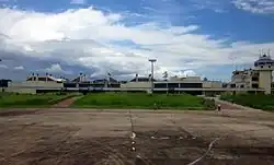
Dimapur is served by the Dimapur Airport located at 3rd Mile (AH1), Chümoukedima District. It is the only civil airport in the state and operates routes to Kolkata, Guwahati, Imphal,[21] and Dibrugarh.
There are plans for expansion of the airport to meet international norms by buying land at Aoyimti village.
Roadways
Highways passing through Dimapur
Railway
Dimapur has direct train services to cities like Guwahati, Kolkata, Patna, New Delhi, Bangalore, Chandigarh, Amritsar, Dibrugarh and Chennai from the Dimapur railway station. The station is categorised as an A category railway station which lies on the Lumding-Dibrugarh section under the Lumding railway division of Northeast Frontier Railway.
It is one of the two railway stations in Nagaland. The other railway station is Shokhüvi Railway Station.[22]
Sports
The Dimapur District Sports Council Stadium is multi-purpose sports stadium in the city while the Nagaland State Stadium is another multi-disciplinary sports stadium currently under construction.[23]
Economy

Dimapur is the commercial centre of Nagaland. It also acts as a transit hub for trading goods brought in from trains at Dimapur railway station and by road via National Highway 29 to other parts of Nagaland. Many private and central banks are also located in the city. Some major hotels are Hotel Acacia (3-star hotel), Hotel Saramati, Hotel Lake Shiloi among many others.
Commerce
A number of shopping centers and markets have sprung up in Dimapur, with the HongKong Market, Central Plaza, New Market, Bank colony (Super Market Area) and Circular and NL roads serving as the main commercial areas in the city. The Complexes and shopping centres have sprung up to Notun Bosti.
The stretch from Purana Bazaar to Chümoukedima along the AH-1 is also rapidly developing into commercial areas.
The city's Hong Kong Market is well known for imported goods from Thailand, China, and Burma and is the main Shopping Attraction for Tourists visiting Nagaland. The wholesale foodgrain items are available at KL Sethi Market Complex, Jasokie Market, etc. at GS Road, Dimapur.
The Agro & Food Processing Special Economic Zone (AFSEZ) at Ganeshnagar under Dimapur District in Nagaland is one of the few exclusive Agro Food Products SEZ in India. It is developed by state-run Nagaland Industrial Development Corporation Limited.[24][25]
Education
Colleges
- Dimapur Government College
- Public College of Commerce
- Salesian College of Higher Education
- Sakus Mission College
- Trinity Theological College
- Unity College
- Pranabananda Women's College
- Cornerstone College
- Ngullie Memorial College
- School of Engineering & Technology, Nagaland University
- Yemhi Memorial College
- St. John College
Schools
- Assembly Of God Higher Secondary School
- Don Bosco Higher Secondary School
- Greenwood School
- Holy Cross School
- Little Star Higher Secondary School
- Living Stone Foundation Higher Secondary School
- N. N. Nagi School
- Pranab Vidyapith Higher Secondary School
- St. John Higher Secondary Residential School
- King David School, Kushiabill
Notable people
- Kevichüsa Angami (1903–1990), Politician
- Zhokhoi Chüzho, Actor
- Zuboni Hümtsoe (1990–2017), Entrepreneur
- Chalie Kevichüsa (1943–1992), Journalist
- Razhukhrielie Kevichüsa (1941–2022), Bureaucrat and Musician
- Tubu Kevichüsa (1948–1996), Nationalist Leader
- Alobo Naga, Musician
- Phulchand Sethi (1911–1976), Businessperson
- Kihoto Hollohon Yepthomi (1932–2021), Politician
See also
Notes
- ↑ "Dimapur City".
- ↑ "Dimapur Info".
- 1 2 3 "Dimapur City Population Census 2011 | Nagaland". www.census2011.co.in.
- ↑ Bathari 2014, pp. 17–18.
- ↑ "The Dimasa Kacharis of Cachar District: An Overview".
- ↑ (Ramirez 2007:93)
- ↑ "SALESIAN PROVINCE OF DIMAPUR". donboscodimapur.org. Archived from the original on 24 March 2014. Retrieved 18 February 2014.
- ↑ District Dimapur, History, dimapur.nic.in, India, retrieved February 12, 2021
- ↑ (Shin 2020:63)
- ↑ "This city is probably the one mentioned in the Ahom Buranji, which records that Ahom king Suhungmung (alias Dihingia Rāja) and his son reached the city by ascending the river Timā (Dima or Dhansiri) in 1526 when the Ahoms attacked Dimapur."(Shin 2020:63)
- ↑ "However, no clear trace of temples and images in the Dimapur ruins raises doubt about the scale and intensity of Brahmanisation in the early history of the Dimasas. The ruins of Dimapur, which include a brick wall of the aggregate length of nearly 2 miles and 2 tanks about 300 yards square, are indicative of a city of considerable size." (Shin 2020:63)
- ↑ NP, Return Dimapur To Assam Demand Grows, nagalandpage.com, India, July 18, 2018
- ↑ EMN, Assam politician wants Dimapur and Merapani from Nagaland, easternmirrornagaland.com, India, September 19, 2016
- ↑ Nagaland Post, Paying the Price of Silence Archived 22 January 2021 at the Wayback Machine, nagalandpost.com, India, September 15, 2018
- ↑ Vinayak, G (2 October 2004). "At least 30 killed in Nagaland blast". Rediff.com. Retrieved 22 August 2022.
- ↑ "India reels after deadly blasts". Al Jazeera. 3 October 2004. Retrieved 22 August 2022.
- ↑ "February Climate History for Dimapur". myweather2.com. Retrieved 18 February 2014.
- ↑ Climate data
- ↑ "Dimapur City religious population". Census India 2011. Retrieved 4 September 2022.
- ↑ "Dimapur Places to Visit". holidayiq.com. Retrieved 18 February 2014.
- ↑ "Alliance Air confirms plans to commence Guwahati-Dimapur-Imphal service in Dec-2019". CAPA. Retrieved 4 December 2019.
- ↑ "Nagaland gets second Railway station after over 100 years | Nagaland Post". 27 August 2022. Retrieved 23 October 2023.
- ↑ "State Stadium Dimapur – Why is it taking so long to complete?". Nagas Connect. 10 May 2020. Retrieved 22 December 2021.
- ↑ "Nagaland Industrial Development Corporation Ltd. (NIDC), Dimapur". Department of Industries & Commerce : Nagaland.
- ↑ "Special Economic Zones". www.pib.gov.in.
References
- Ramirez, Philippe (2007), "Politico-ritual variations on the Assamese fringes: Do social systems exist?", in Sadan, Mandy; Robinne., François (eds.), Social Dynamics in the Highlands of Southeast Asia Reconsidering Political Systems of Highland Burma, Boston: Brill, pp. 91–107
- Bathari, Uttam (2014). Memory History and polity a study of dimasa identity in colonial past and post colonial present (Ph.D.). Gauhati University. hdl:10603/115353.
- Shin, Jae-Eun (2020). "Descending from demons, ascending to kshatriyas: Genealogical claims and political process in pre-modern Northeast India, The Chutiyas and the Dimasas". The Indian Economic and Social History Review. 57 (1): 49–75. doi:10.1177/0019464619894134. S2CID 213213265.