 A view of Dorset Street with the steeple of the neoclassical St.George's Church in the distance | |
 | |
| Native name | Sráid Dorset (Irish) |
|---|---|
| Former name(s) | Drumcondra Lane |
| Namesake | Lionel Sackville, 1st Duke of Dorset |
| Length | 1.1 km (0.68 mi) |
| Width | 21 metres (69 ft) |
| Location | Dublin, Ireland |
| Postal code | D01 |
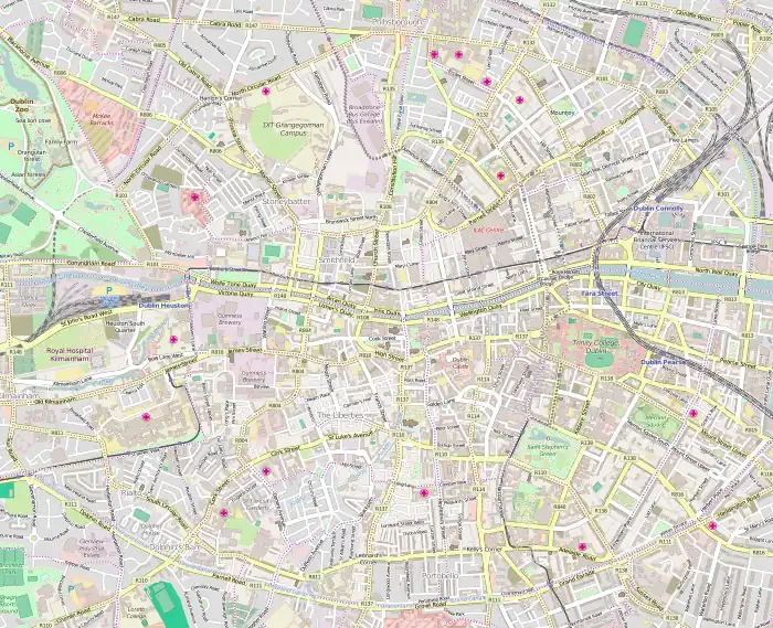
| Coordinates | 53°21′24″N 6°15′53″W / 53.35667°N 6.26472°W |
| southwest end | Dominick Street, Bolton Street |
| northeast end | Drumcondra Road |
| Other | |
| Known for | cafés and restaurants |
Dorset Street (/dɔːrˈsɛt/; Sráid Dorset in Irish) is an important thoroughfare on the northside of Dublin, Ireland, and was originally part of the Slighe Midh-Luchra, Dublin's ancient road to the north that begins where the original bridging point at Church Street is today. Subsequently, yet prior to the street being given its current name in the 18th century, the road was known as Drumcondra Lane and was shown on maps as such. It is divided into Dorset Street Lower (northeast end) and Dorset Street Upper (southwest end).
Location and layout
%252C_Drumcondra%252C_Co._Dublin_(37278984766).jpg.webp)
The street runs northeast from Abbey Street and Bolton Street at Dominick Street junction, north of Parnell Square and Mountjoy Square, and leads into Drumcondra Road at Binn's Bridge on the Royal Canal. It makes up part of the most common route from Dublin Airport to the city centre, and the R132 regional road follows Dorset Street for part of its route.[1] It meets the R135 route at the junctions with Blessington Street, location of the Blessington Street Basin, and St. Mary's Place; other major roads feeding onto this spine street include North Circular Road, Gardiner Street, Eccles Street, North Frederick Street, and Granby Row.
Physically the street rises up from the Liffey valley at its south western end to its apex at roughly where it meets with Blessington and North Frederick Streets; proceeding north-west the street slopes down again on the approach to Binn's Bridge at the Royal Canal.
Some early Georgian houses are dotted along the street, primarily identifiable by the stone Gibbsian doorcase entrances, and close to the crossroads with Blessington and North Frederick Streets. Much of the street redeveloped during the Victorian era, with a number of significant buildings built, such as the Gothic style stone-built Dominican priory, designed by J. L. Robinson in 1884–87 at the corner of Dominick Street, while across from it is the red brick Italianate former fire station, designed by C. J. McCarthy and completed in 1903. Much of the street consists of vernacular Victorian terraces, with shops opening straight onto footpaths at ground-floor level. During the latter part of the twentieth century, stretches of the street were again redeveloped by Dublin Corporation for social housing flat complexes near Dominick Street.
Naming and pronunciation
Until 1728, the street was marked on maps as Drumcondra Lane.[2] Dorset Street was named after Lionel Cranfield Sackville, 1st Duke of Dorset, the Lord Lieutenant of Ireland[3] in 1756.[4] While the English county of Dorset is pronounced with the first syllable stressed, "Dorset Street" is pronounced locally (by Northsiders) as /dɔːrˈsɛt/ Street, with emphasis on the second syllable of "Dorset".[5]
History
St. Joseph's Place Housing Scheme
St Joseph's Place housing scheme has been in planning for many years, which date back as far as 1896. The scheme contained 80 units, with a high density of 30 dwellings per acre. The area named "White's Lane" required major improvements, as the houses were simply inhabitable by means of spatial planning, cleanliness, conveniences, sanitization and many more basic human needs that were desperately needed. Hence under the Housing of the Working Class act, 1890, the improvement scheme for this area was published in October, but by June there was still only partial approval for the loan in order to commence construction. This was due to the displacement of tenants during this time who were sent to areas such as Lurgan Street, Linenhall Street, and Church Street but would not stay in these areas during the construction period for various reasons such as costs and poor sanitation in the houses, and the following year, tenants then began to request compensation for their displacement.[6]
The scheme was then outlined by the City surveyor, Mr Harty, who proposed that the land was completely cleared and constructed an entirely new scheme. This plan consisted of the construction of 80 cottages. Each of them to be one storey high, and a site to construct a boys' national school. This scheme came to life in July 1896 and has not greatly changed since.[6] St. Joseph's Place still consists of these classic one-storey cottages.
Historic residents

- Irish author Seán O'Casey and Irish dramatist and educator Thomas Sheridan were born on this street.[7][8]
- Seán O'Casey was born at number 85, since demolished and replaced by a branch of the Bank of Ireland (now disused), his family having previously occupied numbers 6 and 23½ before moving there. At the time, the street was considered to be a reasonably fashionable location in Dublin.[9]
- Playwright, Westminster Parliament member, and son of Thomas, Richard Brinsley Sheridan was born on this street at number 12 in 1751; Brinsley Sheridan's works include The Critics and A School for Scandal.[10]
- No 16 - site of - was the residence of United Irishman Napper Tandy in 1779
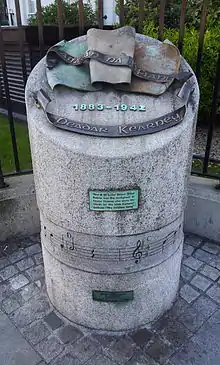
- No 68 - site of - home to Peadar Kearney (1883–1942); Songwriter and author of the national anthem, "The Soldier's Song", also known in Irish as Amhrán na bhFiann. Kearney was born at this address, and by trade became a house painter and theatre set decorator, as too did his more famous nephew, the playwright Brendan Behan, who also lived nearby at Russell Street.
Today

In recent years the street has been improved at its northern end with new trees and lighting; however, the street has been let to deteriorate at its southern city end with stretches of dereliction and vacancy having increased. An over-scaled new "Maldron" hotel built in conjunction with Senator Donie Cassidy now sits on the site of the former National Wax Museum (and before that Plaza Cinema and Bethesda Chapel), and is one of the very few new buildings. Road engineering by Dublin City Council, designed primarily to facilitate cars, continues to prove destructive – with the street now quite notorious as a hostile environment for pedestrians. Nonetheless, the street continues to host a number of pubs, including the very authentic Joxer Daly's, as referenced by Seán O'Casey in Juno and the Paycock, fast food outlets, an assortment of small retail units, and apartments and small offices.
See also
References
- ↑ "Roads Act 1993 (Classification of National Roads) Order 2006". Irish Statute Book. Oireachtas. 13 April 2006. pp. S.I. No. 187/2006. Retrieved 9 April 2011.
- ↑ M'Cready, C. T. (1987). Dublin street names dated and explained. Blackrock, Co. Dublin: Carraig. p. 32. ISBN 1-85068-005-1. OCLC 263974843.
- ↑ Craig, Maurice (2006) [1952]. Dublin 1660-1860 The Shaping of a City. p. 125. ISBN 1-905483-11-2.
- ↑ Clerkin, Paul (2001). Dublin street names. Dublin: Gill & Macmillan. pp. 59–60. ISBN 0-7171-3204-8. OCLC 48467800.
- ↑ Joyce, James; Jackson, John Wyse; McGinley, Bernard (1993). James Joyce's Dubliners: an annotated edition. Sinclair-Stevenson. p. 81. ISBN 978-1-85619-120-3.
- 1 2 Brady, Joseph. Building healthy homes: Dublin Corporation's first housing schemes 1880-1925. Dublin. pp. 65–70. ISBN 0-9500512-6-8. OCLC 1224246136.
- ↑ Reynolds, Horace (23 July 1939). "Sean O'Casey, Up to 12; "I Knock at the Door" Is His Autobiography". The New York Times.
- ↑ McCormack, W. J. (2001). The Blackwell Companion to Modern Irish Culture. Blackwell Publishing. p. 533. ISBN 0-631-22817-9.
- ↑ Christopher Murray (2006). Sean O'Casey. Gill & Macmillan Ltd. p. 19. ISBN 0-7171-2750-8.
- ↑ Brendan Lehane (2001). The Companion Guide to Ireland. Companion Guides. p. 44. ISBN 9781900639347.
Further reading
- Christine Casey (2005). "Dorset Street". Dublin. Yale University Press. pp. 189–191. ISBN 9780300109238.