| Mouramba New South Wales | |||||||||||||||
|---|---|---|---|---|---|---|---|---|---|---|---|---|---|---|---|
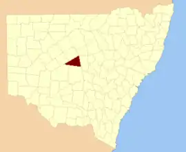 Location in New South Wales | |||||||||||||||
| |||||||||||||||
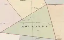
Map of Mouramba County (New South Wales) in 1886.[1]
Mouramba County is one of the 141 Cadastral divisions of New South Wales.
Mouramba is believed to be derived from a local Aboriginal word and is the name of nearby Mouramba Station.[2]
Parishes within this county
The parishes in the county, and mapping coordinates to the approximate centre of each, are:
All are in Cobar Shire.
References
- ↑ from John Sands, Atlas of Australia 1886.
- ↑ "Mouramba County". Geographical Names Register (GNR) of NSW. Geographical Names Board of New South Wales.
This article is issued from Wikipedia. The text is licensed under Creative Commons - Attribution - Sharealike. Additional terms may apply for the media files.