Calvin | |
|---|---|
| Township of Calvin | |
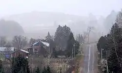
 Rural scene near Eau Claire | |
 Calvin | |
| Coordinates: 46°14′N 78°56′W / 46.233°N 78.933°W | |
| Country | Canada |
| Province | Ontario |
| District | Nipissing |
| Government | |
| • Mayor | Richard Gould |
| Area | |
| • Total | 140.98 km2 (54.43 sq mi) |
| Population (2016)[1] | |
| • Total | 516 |
| • Density | 3.7/km2 (10/sq mi) |
| Time zone | UTC-5 (Eastern (EST)) |
| Postal code | P0H 1V0 |
| Area code | 705 |
| Website | Township of Calvin |
Calvin is a township in northeastern Ontario, Canada on the Mattawa River in Nipissing District. The township took its name from Delino Dexter Calvin, an Ontario lumber merchant and MPP based in Frontenac County.
In 2007, Calvin, along with the town of Mattawa and the townships of Papineau-Cameron, Mattawan and Bonfield cooperated to create a newly branded Mattawa Voyageur Country tourist region in order to promote the area.[2]
Communities

The township comprises the communities of Eau Claire and Eau Claire Station.
Demographics
In the 2021 Census of Population conducted by Statistics Canada, Calvin had a population of 557 living in 227 of its 263 total private dwellings, a change of 7.9% from its 2016 population of 516. With a land area of 140.13 km2 (54.10 sq mi), it had a population density of 4.0/km2 (10.3/sq mi) in 2021.[3]
| 2021 | 2016 | 2011 | |
|---|---|---|---|
| Population | 557 (+7.9% from 2016) | 516 (-9.2% from 2011) | 568 (-6.6% from 2006) |
| Land area | 140.13 km2 (54.10 sq mi) | 140.98 km2 (54.43 sq mi) | 140.69 km2 (54.32 sq mi) |
| Population density | 4/km2 (10/sq mi) | 3.7/km2 (9.6/sq mi) | 4.0/km2 (10/sq mi) |
| Median age | 50.0 (M: 51.6, F: 47.2) | 47.0 (M: 48.0, F: 45.0) | |
| Private dwellings | 263 (total) 227 (occupied) | 251 (total) | 251 (total) |
| Median household income | $72,000 | $48,768 |
See also
References
- ↑ "2016 Census Profile: Calvin, Municipality". Statistics Canada. February 8, 2017. Retrieved June 24, 2019.
- ↑ Adams, K. "Mattawa sports a new look" Archived August 5, 2009, at the Wayback Machine, Baytoday.ca, July 17, 2007. Accessed March 28, 2008.
- ↑ "Population and dwelling counts: Canada, provinces and territories, census divisions and census subdivisions (municipalities), Ontario". Statistics Canada. February 9, 2022. Retrieved March 31, 2022.
- ↑ "2021 Community Profiles". 2021 Canadian Census. Statistics Canada. February 4, 2022. Retrieved October 19, 2023.
- ↑ "2016 Community Profiles". 2016 Canadian Census. Statistics Canada. August 12, 2021. Retrieved June 24, 2019.
- ↑ "2011 Community Profiles". 2011 Canadian Census. Statistics Canada. March 21, 2019.
- ↑ "2006 Community Profiles". 2006 Canadian Census. Statistics Canada. August 20, 2019.
- ↑ "2001 Community Profiles". 2001 Canadian Census. Statistics Canada. July 18, 2021.
External links
