Extreme points are portions of a region which are further north, south, east, or west than any other. This is a list of extreme points in U.S. states, territories, and the District of Columbia.[1]
Although many borders were initially defined by treaty or other agreement to be along a specific line of latitude or longitude, inaccuracies with surveying equipment/techniques caused the surveyed lines to deviate slightly from the true boundaries. Even as equipment/techniques improved, the initial surveyed line still remains the official border,[2] which is why the extreme points may be either side of the agreed-upon line.

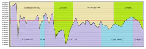
The 49th parallel was agreed to be the border between the United States and British North America (later Canada) from Lake of the Woods to the Strait of Juan de Fuca in the Treaty of 1818 and Oregon Treaty. However, the true boundary line as surveyed deviates several seconds from the true parallel, as seen in this significantly exaggerated depiction
Footnotes
- 1 2 3 4 5 6 7 8 9 10 11 12 13 14 15 16 17 18 19 20 21 22 23 24 25 26 27 28 29 30 31 32 33 34 35 36 37 38 39 40 41 42 43 44 45 This extreme point is on a body of water, but the extreme point on land is not listed as it is less than half a minute away
- ↑ Alaska uniquely straddles the 180 degree east-west meridian, which results in two different definitions of Easternmost and Westernmost points.
- 1 2 3 4 Also the extreme point in all 50 states
- 1 2 3 4 Also the extreme point of the US
- 1 2 Swains Island is disputed with Tokelau
- 1 2 3 4 Also the extreme point in the 48 contiguous states
- ↑ Navassa Island is disputed with Haiti
- ↑ In addition to Navassa Island, Bajo Nuevo Bank and Serranilla Bank, which would be the next most-eastwardly, are also disputed
- ↑ Wake Island is disputed with the Marshall Islands
See also
References
- ↑ All points otherwise unreferenced were found by manually plotting them in "Google Maps".
- ↑ Jacobs, Frank (November 28, 2011), "The Not-So-Straight Story of the U.S.-Canadian Border", New York Times, retrieved November 26, 2023
- ↑ "Point Barrow". Geographic Names Information System. United States Geological Survey, United States Department of the Interior. Retrieved May 3, 2009.
- ↑ "Geographical Positions along the International Boundary, NAD83, O. Portland Canal (Alaska/British Columbia), Turning Point 16". International Boundary Commission.
- ↑ "Pochnoi Point". Geographic Names Information System. United States Geological Survey, United States Department of the Interior. Retrieved May 3, 2009.
- ↑ "Peaked Island". Geographic Names Information System. United States Geological Survey, United States Department of the Interior. Retrieved May 3, 2009.
- ↑ "Amatignak Island". Geographic Names Information System. United States Geological Survey, United States Department of the Interior. Retrieved May 3, 2009.
- ↑ https://sanctuaries.noaa.gov/news/features/0209_rose.html
Rose Atoll Designated A Marine National Monument. Sanctuaries.noaa.gov. Retrieved 14 January 2018. - 1 2 "Why does the eastern border of Utah have a kink in it?". Utah Geological Survey. Retrieved January 31, 2014.
- ↑ "Angelo Towhead". Geographic Names Information System. United States Geological Survey, United States Department of the Interior. January 15, 1980.
- ↑ http://www.legislature.mi.gov/(S(crclotvx1nq5gp55re3x4b3o))/documents/mcl/pdf/mcl-2-201.pdf
- ↑ "North Dakota's Boundaries".
This article is issued from Wikipedia. The text is licensed under Creative Commons - Attribution - Sharealike. Additional terms may apply for the media files.