| Mikata Five Lakes | |
|---|---|
| 三方五湖 | |
IUCN category IV (habitat/species management area) | |
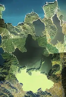
 Aerial Photo of Mikata Five Lakes Made based on National Land Image Information (Color Aerial Photographs), Ministry of Land, Infrastructure, Transport and Tourism | |
 | |
| Location | Japan |
| Nearest city | Mihama, Fukui |
| Coordinates | 35°34′19.9″N 135°53′04.0″E / 35.572194°N 135.884444°E |
| Official name | Mikata-goko |
| Designated | 8 November 2005 |
| Reference no. | 1549[1] |
.jpg.webp)
Mikata Five Lakes (Japanese: 三方五湖, Hepburn: Mikata-goko), also called the Five Lakes of Mikata, are a series of brackish and freshwater lakes located in Mihama and Wakasa, Fukui, Japan, which are close to the coast of Wakasa Bay. They consist of Lakes Mikata (三方湖), Suigetsu (水月湖), Suga (菅湖), Kugushi (久々子湖) and Hiruga (日向湖). These five lakes are all located in Wakasa Wan Quasi-National Park. In 2005 the lakes were designated as a Ramsar site. The Lake Suigetsu is famous for its varves, which were adopted as a global standard for dating geological and historical relics in 2012.[2][3][4][5][6][7][8]
Geography
Mikata Five Lakes refers to Lakes Maikata, Suigetsu, Suga, Kugushi and Hiruga. Lakes Mikata, Suigetsu and Suga, which are located in the southern part, are connected with each other via natural straits. In addition, Urami Canal built in 1664 connects Lake Kugushi with Suigetsu, and Saga Tunnel built in 1934 connects Lake Hiruga with Suigetsu.[5]
| Name | Salinity | Surface area[6] | Elevation[6] | Max depth | Shore length |
|---|---|---|---|---|---|
| Lake Mikata | Fresh water[9] | 3.56 km2 (1.37 sq mi) | 0 m | 5.8 m [10] | 9.6 km (6.0 mi)[11] |
| Lake Suigetsu | Brackish water[12] | 4.16 km2 (1.61 sq mi) | 0 m | 34 m [13] | 11 km (6.8 mi) [13] |
| Lake Suga | Brackish water[6] | 0.91 km2 (0.35 sq mi) | 0 m | 13.0 m [14] | 4.2 km (2.6 mi)[11] |
| Lake Kugushi | Brackish water[11] | 1.40 km2 (0.54 sq mi) | 0 m | 2.5 m [15] | 7.0 km (4.3 mi)[11] |
| Lake Hiruga | Saline water[16] | 0.92 km2 (0.36 sq mi) | 0 m | 38.5 m [16] | 4.0 km (2.5 mi) [16] |
See also
References
- ↑ "Mikata-goko". Ramsar Sites Information Service. Retrieved 25 April 2018.
- ↑ "Mikata Five lakes - Japan National Tourism Organization". Japan National Tourism Organization. Retrieved May 24, 2018.
- ↑ "Five Lakes of Mikata Japan Heritage: Wakasa Province: A Cultural Heritage Linking the Sea to the Ancient Capital". Japan Heritage Utilization Promotion Council of Obama City and Wakasa town. Retrieved May 24, 2018.
- ↑ "Discover Wakasa -Sightseeing-". WAKASA Visitors Association. Retrieved May 24, 2018.
- 1 2 "三方五湖(みかたごこ)とは - コトバンク" (in Japanese). kotobank. Retrieved May 24, 2018.
- 1 2 3 4 "福井県の湿地 (三方五湖 日向湖・久々子湖・菅湖・水月湖・三方湖)" (in Japanese). Fukui Nature Conservation Center. Retrieved May 24, 2018.
- ↑ "水月湖の年縞" (in Japanese). Fukui Prefectural Satoyama-Satoumi Research Institute. Retrieved May 24, 2018.
- ↑ "A Japanese lakebed gives scientists a perfect climate record". Nikkei Inc. Retrieved May 24, 2018.
- ↑ Keiji IWASAKI (2013). "Distribution of the Non-indigenous Mytilid Bivalve Xenostrobus securis along the Sea of Japan's Japanese Coastline". Japanese Journal of Benthology. 67 (2): 73–81. doi:10.5179/benthos.67.73.
- ↑ "三方湖(みかたこ)とは - コトバンク" (in Japanese). kotobank. Retrieved May 24, 2018.
- 1 2 3 4 "日本のラムサール条約登録湿地【三方五湖】" (in Japanese). ラムサール条約登録湿地関係市町村会議. Retrieved May 24, 2018.
- ↑ Hitoshi Fukusawa (1995). "Non-Glacial Varved Lake Sediment as a Natural Timekeeper and Detector on Environmental Changes". The Quaternary Research (Daiyonki-Kenkyu). 34 (3): 135–149. doi:10.4116/jaqua.34.135.
- 1 2 "水月湖(すいげつこ)とは - コトバンク" (in Japanese). kotobank. Retrieved May 24, 2018.
- ↑ "菅湖(すがこ)とは - コトバンク" (in Japanese). kotobank. Retrieved May 24, 2018.
- ↑ "久々子湖(くぐしこ)とは - コトバンク" (in Japanese). kotobank. Retrieved May 24, 2018.
- 1 2 3 "日向湖(ひるがこ)とは - コトバンク" (in Japanese). kotobank. Retrieved May 24, 2018.
External links
- Mikata Five lakes - Japan National Tourism Organization
- Lake Suigetsu - www.suigetsu.org