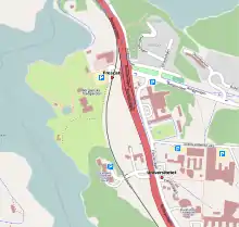
Frescati is a park-like area on the northern outskirts of Stockholm, Sweden. It is situated in an area on Norra Djurgårdsstaden. Frescati is part of the Royal National City Park (Kungliga nationalstadsparken).
History
The name originated with Villa Frescati which was designed in 1791–1792 by the architect Louis Jean Desprez (ca 1743–1804) for courtier and diplomat Gustaf Mauritz Armfelt (1757–1814). The villa is named after the Italian city of Frascati, visited by King Gustavus III during his Italian journey. During the 19th century the name began to be used for a larger area in the vicinity of the house, and the Royal Swedish Academy for Agriculture established its Experimental Field there. It was followed by a number of other scientific and academic institutions, including the Royal Swedish Academy of Sciences, the Swedish Museum of Natural History, the Bergian Garden, a botanical garden, and eventually Stockholm University. Frescati (including the campus area) is today a part of the Royal National City Park.[1][2] [3]
Public transport
In the middle of the area the Metro station Universitetet (The University) and the equally named railway station are located. The railway station is situated at the narrow gauge railway Roslagsbanan. In 2010, the present railway station replaced two earlier stations, Universitetet (situated somewhat further south) and Frescati (usually spelled Freskati; situated somewhat further north).
Gallery
 Frescati railway stop, while it was still in service
 Villa Frescati. 2010
References
- ↑ "Desprez, Jean-Louis". Svenskt biografiskt handlexikon. Retrieved August 1, 2019.
- ↑ "Gustaf Mauritz Armfelt". Biografisket Lexikon of Finland. Archived from the original on June 6, 2010. Retrieved August 1, 2019.
- ↑ "Villa Frescati". nationalstadsparken.se. Retrieved August 1, 2019.