Friendship Bridge Ponte da Amizade | |
|---|---|
.jpg.webp) The Friendship Bridge, with Paraguay on left side and Brazil on the right side. | |
| Coordinates | 25°30′34.5″S 54°36′4.0″W / 25.509583°S 54.601111°W |
| Crosses | Paraná River |
| Locale | Ciudad del Este, Paraguay and Foz do Iguaçu, Brazil |
| Preceded by | Ayrton Senna Bridge |
| Followed by | San Roque González de Santa Cruz Bridge |
| Characteristics | |
| Design | Arch bridge |
| Total length | 552.4 metres (1,812 ft) |
| Longest span | 290 metres (951 ft) |
| History | |
| Opened | 27 March 1965 |
| Location | |
The Friendship Bridge (Spanish: Puente de la Amistad, Portuguese: Ponte da Amizade) is an arch bridge connecting the Brazilian city of Foz do Iguaçu and the Paraguayan city of Ciudad del Este.
History and importance

Paraguayan President Alfredo Stroessner (right) and Brazilian President Humberto de Alencar Castelo Branco, during the opening ceremonies of the Friendship Bridge on 27 March 1965.
The bridge was opened to traffic on 27 March 1965. The space between the main arch is 290 metres (320 yd). The bridge itself is 552.4 metres (604.1 yd) long.
The bridge is very important to the economies of both Foz do Iguaçu and Ciudad del Este.
BR-277 begins immediately after the end of the bridge in the Brazilian side, and National Route N° 7 in the Paraguayan side.
Gallery


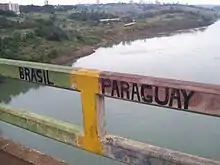 The exact border point along the bridge.
.jpg.webp)
See also
References
External links
Wikimedia Commons has media related to Ponte Internacional da Amizade.
This article is issued from Wikipedia. The text is licensed under Creative Commons - Attribution - Sharealike. Additional terms may apply for the media files.