Fufeng County
扶风县 | |
|---|---|
 | |
 Fufeng in Baoji | |
.png.webp) Baoji in Shaanxi | |
| Coordinates: 34°22′32″N 107°54′01″E / 34.3756°N 107.9002°E | |
| Country | People's Republic of China |
| Province | Shaanxi |
| Prefecture-level city | Baoji |
| Time zone | UTC+8 (China Standard) |
| Website | www |
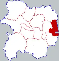
Fufeng County (simplified Chinese: 扶风县; traditional Chinese: 扶風縣; pinyin: Fúfēng Xiàn) is a county under the administration of the prefecture-level city of Baoji, in the west-central part of Shaanxi Province, China. The county lies in the fertile Guanzhong Plain on the north bank of the Wei River between Xi'an, 110 km (68 mi) to the east, and Baoji, 95 km (59 mi) to the west. It has a land area of 751 km2 (290 sq mi), and a population of 450,000 as of 2021.[1]
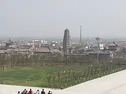
The township of Famen contains the Famen Temple and Zhouyuan Museum (in Zhaochen Village). The Zhouyuan Museum covers archeological excavations of bronzeware from the Zhou dynasty which were discovered nearby.[2][3] A Zhou dynasty capital was located here during the late 11th century.[4] Nowadays Fufeng is mostly reliant on agriculture.[5]
Administrative divisions
As 2019, Fufeng county is divided into 1 subdistrict and 7 towns.[6]
Subdistricts
Towns
Climate
| Climate data for Fufeng (1991–2020 normals, extremes 1981–2010) | |||||||||||||
|---|---|---|---|---|---|---|---|---|---|---|---|---|---|
| Month | Jan | Feb | Mar | Apr | May | Jun | Jul | Aug | Sep | Oct | Nov | Dec | Year |
| Record high °C (°F) | 18.1 (64.6) |
23.6 (74.5) |
29.0 (84.2) |
34.8 (94.6) |
37.0 (98.6) |
41.2 (106.2) |
40.2 (104.4) |
38.8 (101.8) |
38.1 (100.6) |
31.5 (88.7) |
25.3 (77.5) |
22.4 (72.3) |
41.2 (106.2) |
| Mean daily maximum °C (°F) | 5.1 (41.2) |
9.1 (48.4) |
14.8 (58.6) |
21.2 (70.2) |
26.0 (78.8) |
30.9 (87.6) |
31.9 (89.4) |
29.5 (85.1) |
24.4 (75.9) |
18.8 (65.8) |
12.5 (54.5) |
6.7 (44.1) |
19.2 (66.6) |
| Daily mean °C (°F) | −0.7 (30.7) |
3.0 (37.4) |
8.5 (47.3) |
14.5 (58.1) |
19.3 (66.7) |
24.3 (75.7) |
26.3 (79.3) |
24.3 (75.7) |
19.3 (66.7) |
13.3 (55.9) |
6.6 (43.9) |
0.8 (33.4) |
13.3 (55.9) |
| Mean daily minimum °C (°F) | −5.0 (23.0) |
−1.7 (28.9) |
3.4 (38.1) |
8.7 (47.7) |
13.4 (56.1) |
18.4 (65.1) |
21.4 (70.5) |
20.3 (68.5) |
15.4 (59.7) |
9.3 (48.7) |
2.2 (36.0) |
−3.5 (25.7) |
8.5 (47.3) |
| Record low °C (°F) | −13.9 (7.0) |
−12.7 (9.1) |
−9.0 (15.8) |
−1.8 (28.8) |
1.6 (34.9) |
8.6 (47.5) |
13.9 (57.0) |
11.5 (52.7) |
5.8 (42.4) |
−4.4 (24.1) |
−8.5 (16.7) |
−21.5 (−6.7) |
−21.5 (−6.7) |
| Average precipitation mm (inches) | 6.1 (0.24) |
9.1 (0.36) |
23.6 (0.93) |
40.1 (1.58) |
52.4 (2.06) |
66.0 (2.60) |
81.4 (3.20) |
103.2 (4.06) |
100.3 (3.95) |
54.7 (2.15) |
18.8 (0.74) |
3.4 (0.13) |
559.1 (22) |
| Average precipitation days (≥ 0.1 mm) | 3.8 | 4.3 | 6.6 | 7.1 | 9.4 | 9.0 | 9.9 | 10.4 | 12.3 | 10.4 | 5.7 | 2.9 | 91.8 |
| Average snowy days | 4.4 | 3.6 | 1.6 | 0.1 | 0 | 0 | 0 | 0 | 0 | 0 | 1.2 | 2.5 | 13.4 |
| Average relative humidity (%) | 64 | 65 | 65 | 67 | 68 | 65 | 72 | 79 | 82 | 80 | 75 | 67 | 71 |
| Mean monthly sunshine hours | 143.1 | 134.7 | 166.6 | 192.3 | 210.6 | 204.5 | 203.7 | 168.0 | 130.2 | 130.3 | 142.1 | 148.1 | 1,974.2 |
| Percent possible sunshine | 45 | 43 | 45 | 49 | 49 | 47 | 47 | 41 | 35 | 38 | 46 | 48 | 44 |
| Source: China Meteorological Administration[7][8] | |||||||||||||
Culture
Fufeng is known for its vinegar made from grains, which is produced by local rural households.[9] It is also known for a dish combining Douhua and Paomo.[10]
References
- ↑ "扶风县人民政府 区划人口 区划人口". www.fufeng.gov.cn. Retrieved 2021-03-20.
- ↑ Rawson, Jessica (1990). Western Zhou Ritual Bronzes from the Arthur M. Sackler Collections. Arthur M. Sackler Foundation. ISBN 978-0-674-95070-2.
- ↑ Museum, British (2007). The British Museum Book of Chinese Art. British Museum Press. ISBN 978-0-7141-2446-9.
- ↑ "Zhouyuan Site". en.chinaculture.org. Retrieved 2021-03-20.
- ↑ "扶风县人民政府 扶风概况 扶风概况". www.fufeng.gov.cn. Retrieved 2021-03-20.
- ↑ "2019年统计用区划代码". www.stats.gov.cn. Retrieved 2021-08-24.
- ↑ 中国气象数据网 – WeatherBk Data (in Simplified Chinese). China Meteorological Administration. Retrieved 26 August 2023.
- ↑ 中国气象数据网 (in Simplified Chinese). China Meteorological Administration. Retrieved 26 August 2023.
- ↑ "扶风县人民政府 民风民俗 扶风香醋". www.fufeng.gov.cn. Retrieved 2021-03-20.
- ↑ "寶雞:扶風豆花泡饃" (in Chinese (Taiwan)). Retrieved 2021-03-20.