Fuchien Province
福建省 | |
|---|---|
| Name transcription(s) | |
| • Chinese | 福建省 (Fújiàn Shěng) |
| • Abbreviation | FJ / 閩 (pinyin: Mǐn, POJ: Bân) |
| • Foochow | Hók-gióng |
| • Hokkien POJ | Hok-kiàn |
 Seal of Fujian Province | |
.svg.png.webp) Map showing the de facto territories under the nominal province (red) | |
| Coordinates: 24°25′N 118°19′E / 24.417°N 118.317°E | |
| Country | |
| Jiangnandong Circuit | 626 |
| Fujian Circuit | 985 |
| Taiwan as a prefecture of Fujian ruled by the Qing dynasty | 1684 |
| Taiwan as a province of Qing dynasty formally detached from Fujian | 1887 |
| Fujian People's Government | 1933—1934 |
| Division of Fujian | 17 August 1949 |
| Streamlined | 16 July 1956 |
| Demilitarised | 7 November 1992 |
| Provincial Government dissolved | 31 December 2018 |
| Named for | |
| Provincial capital | Jincheng, Kinmen (de facto)[note 1] Foochow (claimed, de jure) |
| Largest city | Jincheng, Kinmen |
| Divisions | 67 counties, 2 cities |
| Government | |
| • Type | Province (nominal) |
| • Body | Kinmen-Matsu Joint Services Center[note 2] |
| Area | |
| • 1948 | 119,340 km2 (46,080 sq mi) |
| • 2018 | 180.4560 km2 (69.6745 sq mi) |
| Population (2020) | |
| • Free area | 153,876 |
| • Constitutional claims | 41,563,668 |
| Demonym(s) | Fujianese, Fukienese, Kinmenese, Matsunese |
| Demographics | |
| • Languages and dialects | Min, Mandarin |
| Time zone | UTC+08:00 (Asia/Taipei) |
| Postal code | 209–212, 890–896 |
| Area code(s) | (0)82, (0)826, (0)836 |
| ISO 3166 code | TW |
| Website | FKPG.gov.tw |
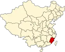
Fuchien Province[upper-roman 1][1] (Mandarin pronunciation: [fǔ.tɕjɛ̂n] ⓘ), also romanized as Fujian and rendered as Fukien, is a nominal province of the Republic of China (ROC, Taiwan) without formal administrative function. It includes three small archipelagos off the coast of the Fujian Province of the People's Republic of China, namely the Matsu Islands, which make up Lienchiang County, and the Wuqiu Islands and Kinmen Islands, which make up Kinmen County. The seat of the administrative centre is Jincheng Township of Kinmen County which serves as its de facto capital. The province is also known as the Golden Horse (simplified Chinese: 金马; traditional Chinese: 金馬; pinyin: jīnmǎ; Pe̍h-ōe-jī: Kim-bé), after the literal reading of the Chinese character abbreviation for "Kinmen-Matsu".
The islands are the only part of a larger province that remain ROC-controlled. The People's Republic of China gained control of the mainland portion in 1949 during the Chinese Civil War. The islands were under military administration during the Cold War; travel restrictions were not lifted until 1992.
Provincial administration was transferred to the national and county governments in 1998 following government reforms. The provincial government was practically abolished in 2018.
History
The Xinhai Revolution deposed the Qing dynasty brought the province into the rule of the Republic of China. Fujian briefly gained independence from China again under the Fujian People's Government until it was recontrolled by the ROC during the Warlord Era.
Parts of the province in the northwestern area of Fujian were controlled by the Jiangxi–Fujian Soviet, a component territory controlled by the Chinese Soviet Republic until its collapse in 1934 at the start of the Long March.
It came under Japanese sea blockade during Second Sino-Japanese War.
During the Chinese Civil War, the ROC lost control of mainland China, including most of Fujian province, and was forced to relocate to Taiwan, while the victorious Chinese Communist forces established the PRC in 1949, subsequently the capital of Fujian was also moved from Foochow to Jincheng. In the Battle of Guningtou, however, ROC forces were able to defend the island of Quemoy (Kinmen) just off the coast of Fujian from communist attack. As a result, the ROC has been able to hold on to a number of offshore islands of Fujian, and has continued to maintain a separate Fujian Provincial Government to govern these islands, parallel to the province of Fujian in mainland China.
In 1956, due to heightened potential for military conflict with the PRC, the ROC central government moved the Fujian provincial government out of Fujian to within Taiwan Province in Xindian (now part of New Taipei), and the islands were placed under an extraordinarily tight military administration due to their extreme proximity to mainland China. This was an unusual situation where the government of a province was located and operating in a different province. With the easing of cross-strait relations between the PRC and ROC and the democratization of the ROC in the 1990s, the islands were returned to civilian government in 1992. On 15 January 1996, the provincial government moved back to Kinmen, on Fujian soil.[2]
Beginning in 2010, the ROC significantly diluted the powers of the two provinces it governs, namely Taiwan and Fujian. Most of the authority at the Fujian province level has been delegated to the two county governments of Kinmen and Lienchiang.
Government
The Governor of Fujian Province was the head of the Fujian Provincial Government, the governor was also titled the "Chairperson of the Fujian Provincial Government". According to the Additional Articles of the Constitution, the governor was appointed by the central government.
The Fujian Provincial Government was located in Jincheng, Kinmen between January 1996 and 2018.
Provincial administration was transferred to counties and the national-level National Development Council in 1998, with the transition occurring in 1999 and 2000.[3] This followed 1997 constitutional reforms to downsize provincial governments. The provincial government was reduced to a local interface for the national government[4] with appointed rather than elected officers;[3] it became dormant[4] when the remaining staff and responsibilities were transferred in 2018.[5]
The Kinmen-Matsu Joint Services Center was founded in 2017[6] as the local government office handling administration of the islands.[7] It took over the remaining responsibilities of the provincial government.[4]
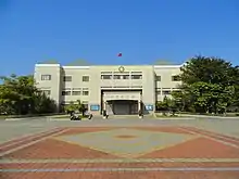
Subdivisions
Fujian province nominally comprises two counties: Kinmen County and Lienchiang County. These islands have a total area of 182.66 km2 (70.53 sq mi) and a total population of 71,000 (2001).
The following are the islands of Fujian under the administration of the ROC, given by county:
| Name | Kinmen County | Lienchiang County |
|---|---|---|
| Chinese | 金門縣 | 連江縣 |
| Hokkien | Kim-mn̂g-koān | Liân-kang-koān |
| Hakka | Kîm-mùn-yen | Lièn-kông-yen |
| Matsunese | Gĭng-muòng-gâing | Lièng-gŏng-gâing |
| Wuqiunese | Ging-meóng-gā̤ⁿ | Léng-gang-gā̤ⁿ |
| Map | 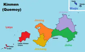 |
.svg.png.webp) |
| Islands | numerous islands & islets[8][9][10] | 36 islands |
|
| |
| Administrative divisions | 6 townships | 4 townships |
The PRC claims Kinmen as a county of Quanzhou, Fujian and the Matsu Islands as a township of Lianjiang County, Fuzhou, Fujian (with some islands claimed as parts of other areas).
Culture and Demography
Culturally, its population is predominantly of Chinese ethnicity, though Fujian remains one of the most culturally and linguistically diverse provinces of the country. Each dialects of the language group Min Chinese were most commonly spoken within the province, including the Fuzhou dialect of northeastern Fujian and various Hokkien dialects of southeastern Fujian. Hakka Chinese is also spoken, by the Hakka people in Fujian. Min dialects, Hakka and Mandarin Chinese are mutually unintelligible. Due to emigration, a sizable amount of the ethnic Chinese populations in Southeast Asia speak Southern Min (or Hokkien).
Education
See also
Notes
- ↑ Note: The Provincial government was dissolved in July 2018. The Kinmen-Matsu Joint Services Center substitutes its administrative functions as local agency of the Executive Yuan located in Jincheng, Kinmen.
- ↑ Fujian Provincial Government before July 2018
Words in native languages
References
- ↑ "Fuchien Provincial Government – 福建省政府 – 國家教育研究院雙語詞彙" (in Chinese (Taiwan)). National Academy for Educational Research.
- ↑ Fujian Provincial Government website Archived 14 April 2009 at the Wayback Machine
- 1 2 Shair-Rosenfield, Sarah (November 2020). "Taiwan" (PDF). Regional Authority Index. Arjan H. Schakel. Retrieved 29 May 2021.
- 1 2 3 Cheung, Han (19 July 2020). "Taiwan in Time: A provincial government that ruled no land". Taipei Times. Retrieved 18 April 2023.
- ↑ Hsiao, Sherry (29 June 2018). "Provincial-level agencies to be defunded next year". Taipei Times. Retrieved 29 May 2021.
- ↑ Huang, Amy; Kao, Evelyn (24 January 2017). "Premier demands efforts to better serve Kinmen, Matsu residents". Focus Taiwan. Archived from the original on 26 January 2017.
- ↑ "中心任務". Kinmen-Matsu Joint Services Center, Executive Yuan. December 2011. Retrieved 18 April 2023.
- ↑ 金門縣行政區域圖 (in Chinese (Taiwan)). Retrieved 9 August 2019.
北碇島 母嶼 白巖 草嶼 東割 烽遂角 后嶼 官澳礁 西園嶼 建功嶼 黑巖 大巖嶼 烏礁 桂子礁 獅嶼 牛心礁 小擔 檳榔嶼 烈嶼 復興嶼 猛虎嶼 兔嶼 石山 大膽島 二擔島 三擔島 四擔島 五擔 大坵島 小坵島
- ↑ "金門地區限制(禁止)水域圖" (PDF) (in Chinese (Taiwan)). Mainland Affairs Council. Retrieved 9 August 2019.
二.限制水域範圍:大金門地區低潮線向外延伸東方海面四千至六千公尺,南方海面八千至一萬公尺,北碇以東海面四千公 尺,大、二膽南海面二千公尺一線以內海域 三、禁止水域範圍:大金門地區低潮線向外延伸東方海面四千公尺,南方海面八千公尺,馬山北方一千五百公尺,北碇以東 海面四千公尺,大、二膽北、西、南海面二千公尺,小金門西海面、檳榔嶼、三腳礁、牛心礁、赤角礁一線以內海域
- ↑ 辞海第六版. Cihai (Sixth Edition) (in Chinese). 上海. Shanghai: 上海辞书出版社. Shanghai Lexicographical Publishing House. September 2009. p. 1124. ISBN 9787532628599.
金门 县名。在福建省东南海上、泉州市西南部。现由台湾省管辖。由以金门岛为主的大、小59个岛屿组成。面积149平方千米,人口约6.45万(2004年)。明置金门千户所,清设金门县丞,属同安县。1913年改隶思明县,1914年析置金门县。1928年直属福建省。农产有甘薯、花生等。矿产有玻璃砂、高岭土、铝土、煤。工业有机械、食品等。特产贡糖、高粱酒、金门马等。通公路。名胜古迹有成功洞、鲁王墓、水尾塔等。{...}金门岛 亦称"大金门岛"、"吾洲屿"。在福建省东南部、厦门港口外台湾海峡中。属金门县,现由台湾省管辖。岛形如哑铃,东西宽,南北狭,中多丘陵,沿海多港湾、口岸。东西长约20千米,面积131.7平方千米。其西有小金门岛。名胜古迹有牧马侯(陈渊)祠、鲁王墓、海印寺、古岗湖、中山纪念林等。
External links
- ROC Fujian Provincial Government (in Chinese)
 Geographic data related to Fuchien Province, Republic of China at OpenStreetMap


.svg.png.webp)