| Monte San Salvatore funicular | |
|---|---|
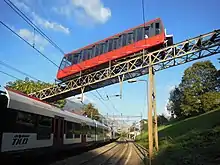
 Lower section car (2010) | |
| Overview | |
| Status | in operation |
| Owner | Funicolare Lugano-Paradiso-Monte San Salvatore SA |
| Locale | Ticino, Switzerland |
| Termini |
|
| Stations | 3 (including "Pazzallo") |
| Service | |
| Type | funicular with 2 sections |
| Operator(s) | Funicolare Lugano-Paradiso-Monte San Salvatore SA |
| Rolling stock | 2 (1 on each section, for 60 passengers each) |
| History | |
| Opened | 27 March 1890 |
| Technical | |
| Track length | 1,630 metres (5,350 ft) |
| Rack system | - (before 1926: Abt) |
| Track gauge | Metre (3 ft 3+3⁄8 in) |
| Electrification | from opening |
| Maximum incline | 61% |
The Monte San Salvatore funicular, or Funicolare Monte San Salvatore, is a funicular railway in the city of Lugano in the Swiss canton of Ticino. The line links a lower station in the Lugano suburb of Paradiso with an upper station at the summit of the Monte San Salvatore. The top yields a 360° panorama with views of the city, Lake Lugano, Monte Generoso and the Italian enclave of Campione.[1]
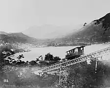
The line was built in 1890, and originally used an Abt rack rail for braking. It was rebuilt in 1926, when the two-axle cars were replaced by four-axle cars capable of carrying 70 passengers each, and the Abt rail removed. The cars were again replaced in 1957. In 2001, the line was extensively modernised, with new engine, gearbox, brakes and control system, and the 1957-built cars were given a new modern style body.[2]

The line has an unusual configuration of two separate single-track sections, with passengers transferring between cars at an intermediate station in Pazzallo. Each section has a single car, but there is only one engine and machine room which is located at Pazzallo, and the two cars counterbalance each other. The two cars are similar in design, but are not identical, being adapted to the different gradients of the two sections.[1][3]
Just after leaving its lower terminal, the funicular crosses above Lugano-Paradiso railway station on a bridge. This station is some 350 metres (1,150 ft) walk to the south of the lower terminal. Urban bus routes 1 and 2 of the Trasporti Pubblici Luganesi (TPL) serve a stop some 150 metres (490 ft) to the north of the terminal at Paradiso Gerreta.[4]


The funicular is owned and operated by Funicolare Lugano-Paradiso-Monte San Salvatore SA.
The Monte San Salvatore funicular is one of three operational funiculars within the Lugano area. The other two are the Monte Brè funicular, which ascends Monte Brè on the opposite side of the city, and the Lugano Città–Stazione funicular, which links the city centre with the railway station.[5]
Operation
The line runs every 30 minutes, with a total journey time of approximately 12 minutes. It has the following parameters:[1][2][3][5]
| Lower section | Upper section | |
|---|---|---|
| Number of cars | 1 | 1 |
| Number of stops | 2 | 2 |
| Configuration | Single track | Single track |
| Mode of operation | Manual | Manual |
| Track length | 815 metres (2,674 ft) | 815 metres (2,674 ft) |
| Rise | 248 metres (814 ft) | 353 metres (1,158 ft) |
| Maximum gradient | 37% | 61% |
| Track gauge | 1,000 mm (3 ft 3+3⁄8 in) metre gauge | 1,000 mm (3 ft 3+3⁄8 in) metre gauge |
| Capacity | 60 passengers per car | 60 passengers per car |
| Maximum speed | 3 metres per second (9.8 ft/s) | 3 metres per second (9.8 ft/s) |
See also
References
- 1 2 3 "MS - Lugano Monte San Salvatore". Funimag. Retrieved 2 April 2012.
- 1 2 "61.028 Lugano Paradiso - M. San Salvatore, Lugano, Funiculare", Schweizer Seilbahninventar = Inventaire suisse des installations à câbles = Inventario svizzero degli impianti a fune [Swiss Inventory of Cableways] (in Italian and German), Federal Office of Culture, retrieved 5 November 2010
- 1 2 "Technical Data". Funicolare Lugano-Paradiso - Monte San Salvatore SA. Retrieved 8 April 2012.
- ↑ "Schema di rete - Trasporti pubblici" [Network diagram - Public transport] (in Italian). Canton of Ticino. Retrieved 19 September 2012.
- 1 2 Eisenbahnatlas Schweiz. Verlag Schweers + Wall GmbH. 2012. pp. 58–59. ISBN 978-3-89494-130-7.
Gallery
 Lake Lugano and the funicular (ca. 1880)
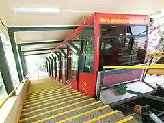
 Upper section car in upper station (2012)
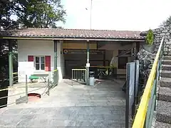
 Upper station near summit of Monte San Salvatore (2012)
External links
 Media related to Funicolare Lugano-San Salvatore at Wikimedia Commons
- Official web site of the Monte San Salvatore funicular
- Article on the funicular from the Funimag online magazine
- "61.028 Lugano Paradiso - M. San Salvatore, Lugano, Funiculare". Schweizer Seilbahninventar = Inventaire suisse des installations à câbles = Inventario svizzero degli impianti a fune [Swiss Inventory of Cableways] (in Italian and German). Federal Office of Culture. 2011.