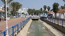
Ga'aton River (1946)

The Ga'aton Stream (Hebrew: נחל הגעתון, Nahal HaGa'aton; Arabic: وادي المفشوج, Wadi al-Mafshukh)[1] is a small river in the Northern District of Israel. It passes through the town of Nahariya before emptying into the Mediterranean Sea. The river runs through the main street of Nahariya, a city that takes its name from the river (nahar means river in Hebrew).[2]
History
In Ottoman times, the river was known as Nahr Mefshukh.[3]
The source of this river, formerly known as "the fountain-head of the waters of Ǧiyāto" (Hebrew: ראש מי גיאתו), and which issued from two natural springs: ʻain a-tinah and ʻain al-ʻanqalit, is mentioned in late 2nd century rabbinic writings (Sifrei on Deuteronomy 11:24), and in the Mosaic of Rehob.[4]
Bibliography
See also
References
- ↑ Khalidi, 1992, p. 19
- ↑ Hunter, Alastair (2005). Psalms. Routledge. p. 139.
- ↑ Survey of Western Palestine, Map 3, grid Le.
- ↑ Raphael Frankel and Israel Finkelstein, in an article published by them, entitled The Northwest Corner of Eretz-Israel in the Baraita ‘Boundaries of Eretz-Israel’, Cathedra: For the History of Eretz Israel and its Yishuv (pub. by: Yad Izhak Ben Zvi), vol. 27, Jerusalem 1983, p. 43. (see: Finkelstein, Israel (1983). "'The Northwest Corner of Eretz-Israel' in the Baraita 'Boundaries of Eratz-Israel'". Cathedra: For the History of Eretz Israel and Its Yishuv. 27: 39–46. JSTOR 23398920.).
This article is issued from Wikipedia. The text is licensed under Creative Commons - Attribution - Sharealike. Additional terms may apply for the media files.
