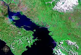
Gulf of Nicoya seen from space (false color)
The Gulf of Nicoya (Spanish: Golfo de Nicoya) is an inlet of the Pacific Ocean. It separates the Nicoya Peninsula from the mainland of Costa Rica, and encompasses a marine and coastal landscape of wetlands, rocky islands and cliffs.
The first Spanish landing in Nicaragua took place here in 1519.[1]
Islands
- Chira Island
- Venado Island
- Isla Caballo
- Isla Bejuco
- Isla San Lucas
- Isla Gitana
- Tortuga Island, Costa Rica

Sunset over the Nicoya Peninsula and Gulf of Nicoya
References
- ↑ Stanislawski, Dan (1983). The Transformation of Nicaragua 1519–1548. Ibero-Americana. Vol. 54. Berkeley; Los Angeles: University of California Press. ISBN 0-520-09680-0.
External links
9°48′N 84°48′W / 9.8°N 84.8°W
This article is issued from Wikipedia. The text is licensed under Creative Commons - Attribution - Sharealike. Additional terms may apply for the media files.