Goulburn
New South Wales
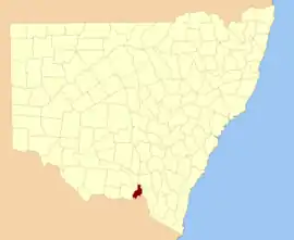
Location in New South Wales
Lands administrative divisions around Goulburn:
Mitchell Wynyard Wynyard
Hume Goulburn Selwyn
Bogong (Vic) Benambra (Vic) Selwyn
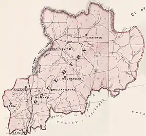
1886 map of Goulburn county

Goulburn County is one of the 141 Cadastral divisions of New South Wales. It contains the city of Albury, and the towns of Jindera, Bowna and Woomargama.

Goulburn County was named in honour of the statesman, Henry Goulburn (1784-1856).[1]

Parishes within this county

A full list of parishes found within this county; their current LGA and mapping coordinates to the approximate centre of each location is as follows:

ParishLGACoordinates
AlburyCity of Albury36°02′54″S 146°54′04″E / 36.04833°S 146.90111°E / -36.04833; 146.90111 (Albury)
Back CreekGreater Hume Shire Council35°37′54″S 147°21′04″E / 35.63167°S 147.35111°E / -35.63167; 147.35111 (Back Creek)
BillabungGreater Hume Shire Council35°37′54″S 147°30′04″E / 35.63167°S 147.50111°E / -35.63167; 147.50111 (Billabung)
BownaGreater Hume Shire Council35°59′54″S 146°03′04″E / 35.99833°S 146.05111°E / -35.99833; 146.05111 (Bowna)
CarabobalaGreater Hume Shire Council35°40′54″S 147°15′04″E / 35.68167°S 147.25111°E / -35.68167; 147.25111 (Carabobala)
CarabostGreater Hume Shire Council35°35′54″S 147°33′04″E / 35.59833°S 147.55111°E / -35.59833; 147.55111 (Carabost)
CoocookGreater Hume Shire Council35°43′54″S 147°33′04″E / 35.73167°S 147.55111°E / -35.73167; 147.55111 (Coocook)
CookardiniaGreater Hume Shire Council35°35′54″S 147°15′04″E / 35.59833°S 147.25111°E / -35.59833; 147.25111 (Cookardinia)
CoppabellaGreater Hume Shire Council35°44′54″S 147°42′04″E / 35.74833°S 147.70111°E / -35.74833; 147.70111 (Coppabella)
CumboroonaGreater Hume Shire Council35°58′54″S 147°12′04″E / 35.98167°S 147.20111°E / -35.98167; 147.20111 (Cumboroona)
CurrajongGreater Hume Shire Council35°50′54″S 147°38′04″E / 35.84833°S 147.63444°E / -35.84833; 147.63444 (Currajong)
Dora DoraGreater Hume Shire Council35°51′54″S 147°23′04″E / 35.86500°S 147.38444°E / -35.86500; 147.38444 (Dora Dora)
Forest CreekGreater Hume Shire Council35°34′54″S 147°30′04″E / 35.58167°S 147.50111°E / -35.58167; 147.50111 (Forest Creek)
GerogeryGreater Hume Shire Council35°52′24″S 147°01′04″E / 35.87333°S 147.01778°E / -35.87333; 147.01778 (Gerogery)
HolbrookGreater Hume Shire Council35°42′54″S 147°20′04″E / 35.71500°S 147.33444°E / -35.71500; 147.33444 (Holbrook)
HumeGreater Hume Shire Council35°52′54″S 147°15′04″E / 35.88167°S 147.25111°E / -35.88167; 147.25111 (Hume)
HuonGreater Hume Shire Council35°52′54″S 146°55′04″E / 35.88167°S 146.91778°E / -35.88167; 146.91778 (Huon)
JergyleGreater Hume Shire Council35°48′54″S 147°23′04″E / 35.81500°S 147.38444°E / -35.81500; 147.38444 (Jergyle)
Jerra JerraGreater Hume Shire Council35°28′54″S 147°13′04″E / 35.48167°S 147.21778°E / -35.48167; 147.21778 (Jerra Jerra)
JinderaGreater Hume Shire Council35°57′54″S 146°55′04″E / 35.96500°S 146.91778°E / -35.96500; 146.91778 (Jindera)
JingellicGreater Hume Shire Council35°54′54″S 147°39′04″E / 35.91500°S 147.65111°E / -35.91500; 147.65111 (Jingellic)
Little BillabungGreater Hume Shire Council35°29′54″S 147°31′04″E / 35.49833°S 147.51778°E / -35.49833; 147.51778 (Little Billabung)
MitchellGreater Hume Shire Council35°47′54″S 147°18′04″E / 35.79833°S 147.30111°E / -35.79833; 147.30111 (Mitchell)
Mountain CreekGreater Hume Shire Council35°46′54″S 147°15′04″E / 35.78167°S 147.25111°E / -35.78167; 147.25111 (Mountain Creek)
MullengandraGreater Hume Shire Council35°53′54″S 147°11′04″E / 35.89833°S 147.18444°E / -35.89833; 147.18444 (Mullengandra)
MungabarinaGreater Hume Shire Council35°01′54″S 146°57′04″E / 35.03167°S 146.95111°E / -35.03167; 146.95111 (Mungabarina)
MurrayGreater Hume Shire Council35°37′24″S 147°32′04″E / 35.62333°S 147.53444°E / -35.62333; 147.53444 (Murray)
Narra Narra WaGreater Hume Shire Council35°47′54″S 147°32′04″E / 35.79833°S 147.53444°E / -35.79833; 147.53444 (Narra Narra Wa)
PulletopGreater Hume Shire Council35°33′54″S 147°21′04″E / 35.56500°S 147.35111°E / -35.56500; 147.35111 (Pulletop)
TalmalmoGreater Hume Shire Council35°51′54″S 147°33′04″E / 35.86500°S 147.55111°E / -35.86500; 147.55111 (Talmalmo)
ThurgoonaCity of Albury36°03′54″S 147°00′04″E / 36.06500°S 147.00111°E / -36.06500; 147.00111 (Thurgoona)
VautierGreater Hume Shire Council35°51′54″S 147°30′04″E / 35.86500°S 147.50111°E / -35.86500; 147.50111 (Vautier)
WagraGreater Hume Shire Council35°58′54″S 147°15′04″E / 35.98167°S 147.25111°E / -35.98167; 147.25111 (Wagra)
WoomargamaGreater Hume Shire Council35°48′54″S 147°10′04″E / 35.81500°S 147.16778°E / -35.81500; 147.16778 (Woomargama)
WyndhamGreater Hume Shire Council35°56′54″S 147°07′04″E / 35.94833°S 147.11778°E / -35.94833; 147.11778 (Wyndham)
YamblaGreater Hume Shire Council35°55′54″S 147°01′04″E / 35.93167°S 147.01778°E / -35.93167; 147.01778 (Yambla)
YararaGreater Hume Shire Council35°41′54″S 147°39′04″E / 35.69833°S 147.65111°E / -35.69833; 147.65111 (Yarara)
Yarra YarraGreater Hume Shire Council35°42′54″S 147°27′04″E / 35.71500°S 147.45111°E / -35.71500; 147.45111 (Yarra Yarra)

References

  1. "Goulburn County". Geographical Names Register (GNR) of NSW. Geographical Names Board of New South Wales.
This article is issued from Wikipedia. The text is licensed under Creative Commons - Attribution - Sharealike. Additional terms may apply for the media files.