 | |
| Former names | Guangzhou Public Stadium |
|---|---|
| Location | Guangzhou, People's Republic of China |
| Public transit | Martyrs' Park 1 |
| Owner | Guangzhou Government |
| Capacity | 15,000 |
| Surface | Grass |
| Construction | |
| Opened | 1932 |
| Renovated | 1946 1950s–60s 1990 |
| Tenants | |
| Guangdong Sunray Cave (2010–2014) Guangzhou Evergrande (1998–2000) | |
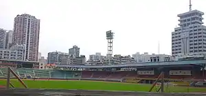
The Guangdong Provincial People's Stadium (Chinese: 广东省人民体育场) is a multi-purpose stadium in Guangzhou, China. It is currently used mostly for football matches. The stadium holds 15,000 people. The stadium is best reached by taking Guangzhou Metro Line 1 to Martyrs' Park Station.[1]
History
Formerly known as the dongjiaochang or Eastern Parade Ground, the site was first used as a sporting venue in 1906 when it hosted Guangdong's (and China's) first ever provincial level athletics competition. Sun Yat-Sen ordered the construction of a stadium on the site in 1922 but it wasn't finished until 1932.[2]
It was used as a Japanese transport and supplies depot during the occupation of Guangzhou and was bombed when Guangzhou was liberated.
Construction of Yuexiushan meant that the People's Stadium didn't hold many high-profile sporting or civic events from the mid 1950s onwards.[3] However, it did host many games in the Guangdong-Hong Kong Cup as well as games in the inaugural Women's World Cup in 1991.[2]
Recent use
For the 2017 Chinese Super League Season, Guangzhou R&F F.C. used the stadium as their temporary home for their first two matches whilst Yuexiushan was being refurbished.[4]
References
- ↑ 广东省人民体育场 at guangzhou.alltrip.cn Retrieved 2014-09-01
- 1 2 "From the Qing dynasty, to collapsing roofs and the CSL: a history of Guangzhou R&F's temporary home". Wild East Football. 2017-03-10. Retrieved 2017-04-05.
- ↑ "Yuexiushan: The cradle of Cantonese football, part one". Wild East Football. 2016-09-13. Retrieved 2017-04-05.
- ↑ "Alexandre Pato the villain as Tianjin Quanjian lose CSL opener to Guangzhou R&F". Wild East Football. 2017-03-04. Retrieved 2017-04-05.
External links
- Guangdong Provincial People's Stadium at Sports.qq.com

.JPG.webp)
