Gwangju
광주시 | |
|---|---|
| Korean transcription(s) | |
| • Hangul | 광주시 |
| • Hanja | 廣州市[1] |
| • Revised Romanization | Gwangju-si |
| • McCune-Reischauer | Kwangju-si |
 | |
 Flag  Emblem of Gwangju | |
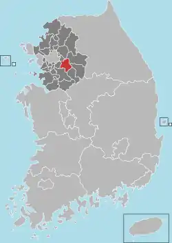
 Location in South Korea | |
| Country | |
| Region | Gyeonggi Province (Sudogwon) |
| Administrative divisions | 2 eup, 10 dong, 4 myeon |
| Government | |
| • mayor | Sehwan Bang (방세환) |
| Area | |
| • Total | 430.99 km2 (166.41 sq mi) |
| Population (October, 2022) | |
| • Total | 391,722 |
| • Density | 910/km2 (2,400/sq mi) |
| • Dialect | Seoul |
Gwangju[lower-alpha 1] (Korean pronunciation: [kwaŋ.dzu]) is a city in Gyeonggi Province, South Korea, a suburb southeast of Seoul. The city is not to be confused with the much larger Gwangju Metropolitan City, former capital of South Jeolla Province, South Korea.
History
Bunwon-ri in Gwangju took an important role of ceramic production during the Kingdom of Joseon. There had official kilns and produced superb quality of white porcelains for use at the royal court and to export to China.[3]
In 1962, 4 myeons (townships) including 5 ris (villages) were incorporated to Seoul.[4]
In 1973, 6 ris were separated and became a part of Seongnam city. In 1979, Gwangju-myeon was elevated to an eup. Gwangju county became a city in 2001.[5]
Festival
Gwangju Toechon Tomato Festival - Gwangju City, Gyeonggi Province has been holding a festival since 2003 to promote the city's pollution-free tomatoes and sell them to consumers.
Climate
Gwangju has a monsoon-influenced humid continental climate (Köppen: Dwa) with cold, dry winters and hot, rainy summers.
| Climate data for Gwangju, Gyeonggi (1993–2020 normals) | |||||||||||||
|---|---|---|---|---|---|---|---|---|---|---|---|---|---|
| Month | Jan | Feb | Mar | Apr | May | Jun | Jul | Aug | Sep | Oct | Nov | Dec | Year |
| Mean daily maximum °C (°F) | 2.2 (36.0) |
5.4 (41.7) |
11.7 (53.1) |
18.6 (65.5) |
23.9 (75.0) |
27.8 (82.0) |
29.2 (84.6) |
30.2 (86.4) |
26.0 (78.8) |
20.0 (68.0) |
11.9 (53.4) |
3.9 (39.0) |
17.6 (63.7) |
| Daily mean °C (°F) | −3.3 (26.1) |
−0.4 (31.3) |
5.3 (41.5) |
11.8 (53.2) |
17.2 (63.0) |
21.8 (71.2) |
24.7 (76.5) |
25.2 (77.4) |
20.2 (68.4) |
13.3 (55.9) |
6.1 (43.0) |
−1.4 (29.5) |
11.7 (53.1) |
| Mean daily minimum °C (°F) | −8.2 (17.2) |
−5.7 (21.7) |
−0.5 (31.1) |
5.5 (41.9) |
11.2 (52.2) |
16.8 (62.2) |
21.2 (70.2) |
21.6 (70.9) |
16.0 (60.8) |
8.2 (46.8) |
1.0 (33.8) |
−6.1 (21.0) |
6.8 (44.2) |
| Average precipitation mm (inches) | 16.6 (0.65) |
25.0 (0.98) |
35.5 (1.40) |
67.5 (2.66) |
91.4 (3.60) |
118.1 (4.65) |
374.4 (14.74) |
317.6 (12.50) |
140.5 (5.53) |
55.9 (2.20) |
45.8 (1.80) |
19.8 (0.78) |
1,308.1 (51.50) |
| Average precipitation days (≥ 0.1 mm) | 3.4 | 3.5 | 5.3 | 6.8 | 6.6 | 7.6 | 12.9 | 13.0 | 7.5 | 5.2 | 6.8 | 4.8 | 83.4 |
| Source: Korea Meteorological Administration[6] | |||||||||||||
Notable people
- Ahn Sun-ju (1987), professional golfer
- Kim Yu-bin (1988), singer and actress
- Choi Soo-young (1990), singer and actress, member of Girls' Generation.
- Lee Hong-gi (1990), singer and actor
- Lee Hye-ri (1994), singer and actress
- Julio Ko (1970), kayaker and educator
- Yoon Shi-yoon (1986), actor and variety entertainer
- Hyungwon (1994), member of boy group Monsta X
- Lee Ju-yeon (1998), member of boy group The Boyz
International relations
Sister cities
Friendship cities
 Faku County, Liaoning, China
 Dornogovi Province, Mongolia
.svg.png.webp) Bathurst, New South Wales, Australia
Bathurst, New South Wales, Australia
See also
Notes
References
Citations
- ↑ 광주역사-연혁. Archived from the original on 2014-07-18.
- ↑ EB (1878), p. 390.
- ↑ John Onians (2004). Atlas of World Art. Laurence King Publishing. p. 205p. ISBN 978-1-85669-377-6.
Government-sponsored kilns at punwon-ri, near Seoul, produced an exquisite and distinctive Joseon white porcelain for use at court and for export to China. Its undecorated cream-colored surfaces, and austere elegant shapes were thought to reflect a purity of mind and moral character appropriate for Neo-Confucian patrons.
- ↑ Law concerning Seoul metropolitan city, provinces, counties, districts and counties(1962. 11. 21.)
- ↑ Establishment of new cities including Hwasung.(2000. 12. 20.)
- ↑ "Climatological Normals of Korea (1991 ~ 2020)" (PDF) (in Korean). Korea Meteorological Administration. Archived from the original (PDF) on 29 January 2022. Retrieved 7 June 2023.
Bibliography
- , 'Encyclopædia Britannica, 9th ed., Vol. VI, New York: Charles Scribner's Sons, 1878, pp. 390–394.
External links
- City government website (in English)
- City Council website Archived 2019-04-03 at the Wayback Machine (in Korean)
37°22′N 127°17′E / 37.367°N 127.283°E
