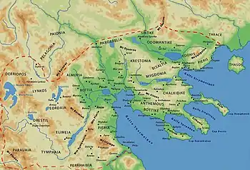
Map of Macedon
Heracleium or Herakleion (Ancient Greek: Ἡράκλειον) was a city on the south coast of ancient Pieria, Macedon, between Phila and Leibethra. During Peloponnesian war it passed into Athenian control in the years 430/29, 425/4 and 421 BCE. After Athenian alliance with Perdiccas II in 413 BCE it became again a city of Macedon.
References
- ↑ Richard Talbert, ed. (2000). Barrington Atlas of the Greek and Roman World. Princeton University Press. p. 50, and directory notes accompanying.
- ↑ Lund University. Digital Atlas of the Roman Empire.
- The Athenian Tribute Lists by Benjamin D. Meritt
- An Inventory of Archaic and Classical Poleis By Mogens Herman Hansen, Thomas Heine Nielsen
- Two Studies in Ancient Macedonian Topography - Page 46 by Miltiadēs V. Chatzopoulos, Louiza D. Loukopoulou
- CNN Transcript: Archaeologists Discover Ancient Cities Under Mediterranean
39°58′N 22°38′E / 39.97°N 22.64°E
This article is issued from Wikipedia. The text is licensed under Creative Commons - Attribution - Sharealike. Additional terms may apply for the media files.